When you click on links to various merchants on this site and make a purchase, this can result in this site earning a commission. Affiliate programs and affiliations include, but are not limited to, the eBay Partner Network.
mrjonger also recommends the Tomales to Stinson Beach part of this route
However niacin has noted (and confirmed by mrjonger as of late-September 2018) that the stretch from south of Valley Ford Road and north of Fallon is down to a single lane with a timed stoplight and is slow to get through: https://goo.gl/maps/jgr7iaxbdtH2
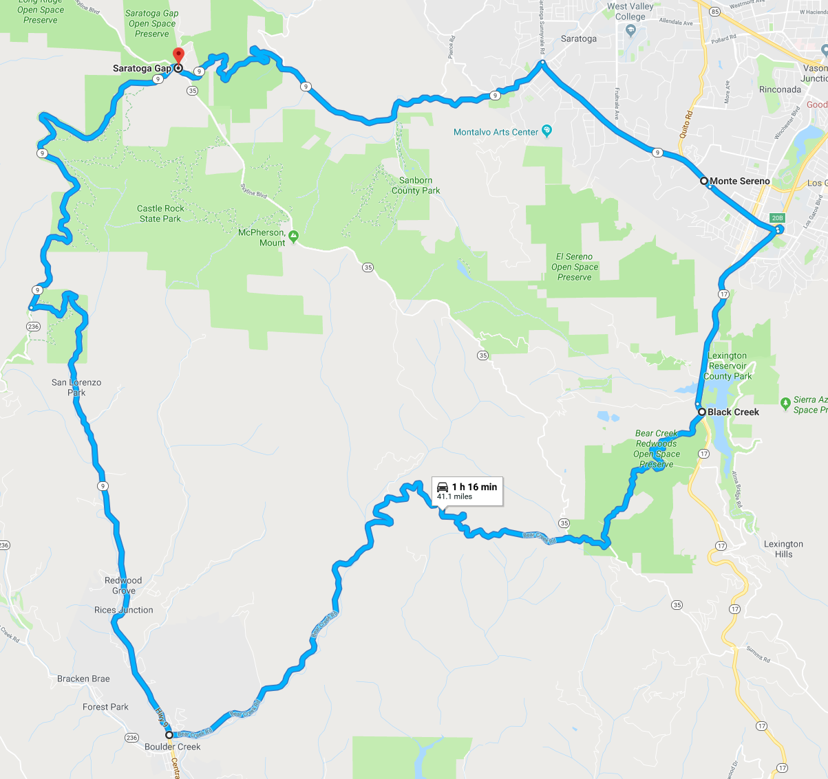
Got to take the GT3 out for a spin on Sunday, haven't done much road driving in the past few months (various life stuff and time on the track instead, yay) but, finally made it out yesterday with a mate in his Turbo and covered this route (https://goo.gl/maps/Pycmf1HK3e62). I haven't linked all these pieces of road together before and it makes for a nice loop, we chose to start on Skyline and 9 as we had headed south from Alice's. I'd suggest doing it counter clockwise before the afternoon peak hour (on the weekends) from Santa Cruz back to the Bay Area and 17 gets congested.
As usual the start heading south on ( from 35) is awesome, lots of nice twisties and good pavement. Then take a left on Bear Creek Rd just before Boulder Creek, I hadn't been on this before and reading the posts on here said it was kinda bumpy. It wasn't too bad in the GT3, there were some largish bump sections but you could easily see them and slow and then keep going. The far eastern end towards 17 gets tighter and bumpier but just cruise that bit if needed. Then take left on 17, jump back on 9 and then head uphill back to 35 at Saratoga Gap - again 9 has amazing pavement, good turns and is a lot of fun. Then repeat for another 41 miles or head on to your next adventure.
Word of warning for anyone thinking of running 58, they are resurfacing a major section of the road about 15 miles east of Santa Margarita and there�s a lot of tar and gravel. I expect they have a fair bit to go so it could be a while before it�s done. They have recently repaved a lot of the road all the way back to McKittrick, so it should be terrific come spring.
The road getting to the tree tunnel looks like it's been hit by mortar rounds. It is also flooded at the end, I was unable to get through in my GT3. I do not recommend it.
Yes, it was a bumpy drive as stated in my notes. I do recall some standing water near the end, but it was very shallow and manageable in my cab. It had also been raining all morning, I guess mistakenly assumed that it's normally dry. I'm really sorry about that, I should have thought of those with sportier set ups. I hope the tree was not the final destination. If we ever happen to meet, I'll pick up the tab.
McKittrick to Santa Margarita. Awesome the whole way. Be careful in the first section where the cliffs are big. There is no railing and it�s a long, long way down in spots. I can�t imagine it would be survivable if you went over.
Stumbled across this review shot up around Mt. Tamalpais. I know there’s been limited recommendations for roads specifically around Mt. Tam (and I don’t know the area myself), but they look decent in the video...
Stumbled across this review shot up around Mt. Tamalpais. I know there�s been limited recommendations for roads specifically around Mt. Tam (and I don�t know the area myself), but they look decent in the video...
Karl, the following link will take you to a longer version of the road that they used for this video: https://goo.gl/prSfc1
The portion that they used for the video is located between the Rock Springs Trailhead & intersection of West Ridgecrest Blvd & Fairfax-Bolinas Rd, which is gated & closed during the evening hours (unsure of the exact closure hours so best to check first before heading up there). My preference is to head uphill from Bolinas, but both directions are fun. There often are more bikes on the road than cars. I would not head down the Fairfax-Bolinas Rd to Fairfax as that road is in bad shape.
 10-04-2018, 01:56 PM