When you click on links to various merchants on this site and make a purchase, this can result in this site earning a commission. Affiliate programs and affiliations include, but are not limited to, the eBay Partner Network.
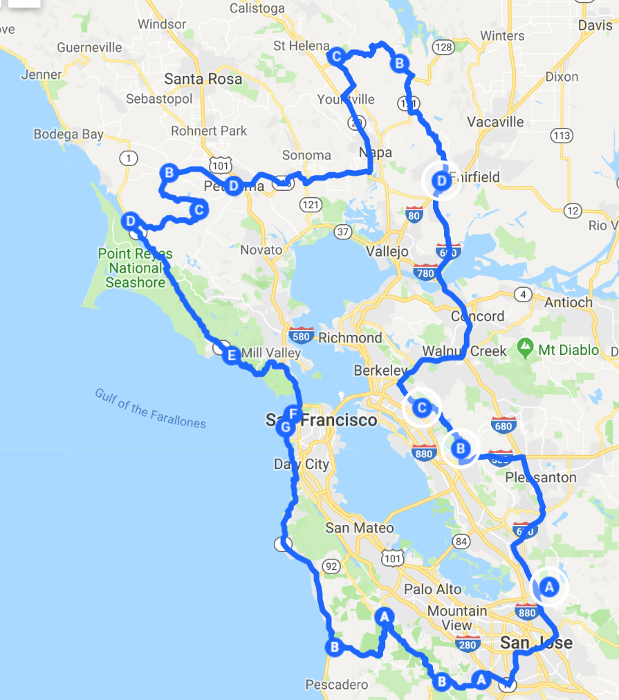
So, I've put together a start to the Bayschleife (roughly 250 miles of mostly twisty roads) - Link is here, I need help building the East Bay and North Bay sections, all suggestions welcome
This really disappoints me... I haven't driven those roads in a couple of years and was just thinking that I should revisit that route. Would you say the issues with the road surface are mostly potholes, or irregular patching, or debris...?
Thanks,
Rich
The road is just very poorly maintained in my opinion. Mines Rd has areas with loose gravel on the road surface so I hear it hitting my fenders and the windscreen from the guys in front of me and there are a few areas from Livermore to The Junction restaurant that are basically one lane roads with tight corners. Some stretches have large imperfections and there are or were some areas that were damaged from the rains the last few years. I've done the Mt. Hamilton drive several times as well and it is full of cyclists, that takes the enjoyment out of it for me. I came upon several guys leaning into my lane as they were going downhill around a few of the many blind corners on one particular day. After that I haven't been back. From The Junction to Patterson is glorious though and feels like you're in a different state almost, just the occasional cattle guard on the road.
If you're going to do it, you need to leave very early to get up Mt. Hamilton and then continue on to Patterson on Mines Rd, that is the best route.
So, I've put together a start to the Bayschleife (roughly 250 miles of mostly twisty roads) - Link is here, I need help building the East Bay and North Bay sections, all suggestions welcome
I would disagree somewhat. It's not the greatest surface, but more than adequate for spirited driving. PCA-GGR did Livermore to Lick Observatory and back to Livermore in March via Mines Rd, and it was fine. No bicyclists on that side. I won't do San Jose up to the Observatory. There you have many bicyclists, especially weekends.
But the more who stay off it, the more room for me!
So, I've put together a start to the Bayschleife (roughly 250 miles of mostly twisty roads) - Link is here, I need help building the East Bay and North Bay sections, all suggestions welcome
If you want to help edit this please PM me and I can share you edit access to the file (with your email address)
I concur with the Lt on this, section A(ish), instead of 84, go 580 to Livermore Ave, it turns into Tesla, then make a right on Mines. Takes you to Milpitas, same road as the Tour of California. It's Not too crowded and cyclists (of which I am one) have plenty of room....(well, in parts)
So, I've put together a start to the Bayschleife (roughly 250 miles of mostly twisty roads) - Link is here, I need help building the East Bay and North Bay sections, all suggestions welcome
Its missing some of the best parts of Lake Berryessa. It needs to extend up and loop around at the north end of the lake. I can share when I have a link.
Also im not sure about that route from Pt Reyes to Petaluma. I would need better resolution to see which roads those are. Some in there are great, some are goat paths.
Not a huge fan of 29 or anything through Napa. Just sitting in traffic if its a weekend. We typically cut over to Yountville from Lake Hennessey for lunch, then double back to take the back roads down to 80. Interested to try all those roads in the east bay. Never been to those before.
Field Report: Drove Redwood Road (East Bay) this morning at around 7 AM and saw just one cyclist the whole time, after doing the full length in both directions. Not as dire as foretold in the OP.
So, I've put together a start to the Bayschleife (roughly 250 miles of mostly twisty roads) - Link is here, I need help building the East Bay and North Bay sections, all suggestions welcome
If you want to help edit this please PM me and I can share you edit access to the file (with your email address)
I know the north bay a bit. Can't tell from the map: The Pt Reyes Station to Petaluma is quite nice but the Marshall to Petaluma is more suited for Cayennes and not for sport cars
Field Report: Drove Redwood Road (East Bay) this morning at around 7 AM and saw just one cyclist the whole time, after doing the full length in both directions. Not as dire as foretold in the OP.
Originally Posted by visitador
I know the north bay a bit. Can't tell from the map: The Pt Reyes Station to Petaluma is quite nice but the Marshall to Petaluma is more suited for Cayennes and not for sport cars
Thanks. I may also mention that the uphill leg of the Bolinas to Mt Tam trip is the same as the Fairfax -Bolinas Rd. That is, not suitable for sports cars. If you want to do Ridgecrest (that is, the road used by Motor Trend), I would suggest going all the way to Stinson Beach on Highway 1 and go up via Panoramic and then enter Riidgecrest. Panoramic is a great twisty road that can be enjoyed early in the morning going up hill before the tourist crowd show up (don't come downhill from Mill Valley or Sausalito because you'll most likely be stuck behind a rental car driver who ignores the pull over signs)
Google warns of "restricted usage or private roads"
Thanks.
Karl.
It is restricted in the sense that the gates are locked from sunset to sunrise (on both sides of Ridgecrest - either entering from Bolinas-Fairfax Rd or from Panoramic).
I've driven and ridden all of the roads listed in the initial post in a sports car or on a motorcycle plus a few not mentioned. Learned the routes initially by riding them, since I was riding motorcycles long b4 I drove sports cars.
Part of a route included in the 250 mile loop map but not specifically mentioned in the initial post is a run that starts (for me) at Cordelia off 680. There are 3 variations of this loop; 1 short, 1 medium and 1 long.
1) Exit Cordelia off of 80/680 and head north on Suisun Valley Road. SVR becomes Wooden Valley Road until it dead ends on 121. Turn rt on 121 until it intersects w/128. Turn left (north) on 128 towards Berryessa and loop back on 128 to Silverado Trail at the lower valley where you can choose to have breakfast/lunch in Yountville or in downtown Napa or just head home. You can do this in just an hour w/o stops. Aubuerge du Soleil is a great place to stop for brunch/lunch if you take this route.
2) For the medium route, do NOT loop back to Napa on 128 but turn rt at Lower Chiles Valley Road which dead ends on Chiles Pope Valley Road. Turn rt on CPVR and drive north to Pope Valley where you can turn west up Howell Mountain Road and down to Silverado Trail mid-Valley near St. Helena; Calistoga is just a short drive north on Silverado. Lots of places in both towns where you can eat/drink. You can do this route in just a couple hrs w/o stops.
3) For the long route, do NOT head west up Howell Mountain Road but continue up CPVR which becomes Pope Valley Road and then Butts Canyon Road all the way into Middletown. Haven't been to Middletown since the fire that destroyed it in 2015 but there use to be a couple of nice breakfast places and a brewery there. Don't know now. Use to stay overnight at Harbin Hots Springs which was also destroyed in the fire. To avoid traffic you can just head back the way you came and take Howell Mt Road into the valley if that's where you want to go or you can do a loop back to Napa from Middletown via Hwy 29/Silverado Trail. This is 3-4 hr route w/o stops but I usually make an all day 6-7 hr trip of it.
It is restricted in the sense that the gates are locked from sunset to sunrise (on both sides of Ridgecrest - either entering from Bolinas-Fairfax Rd or from Panoramic).
Understood. I've added your recommendation to the top post.
Originally Posted by sgt1372
I..There are 3 variations of this loop; 1 short, 1 medium and 1 long...
Thanks. But it'll be 1-2 weeks before I've time to come back and update the top post with your recommendations.
 06-25-2019, 04:52 PM