When you click on links to various merchants on this site and make a purchase, this can result in this site earning a commission. Affiliate programs and affiliations include, but are not limited to, the eBay Partner Network.
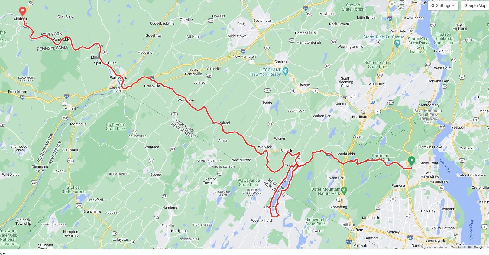
UDPATED TO SHOW WHAT I THINK IS OUR BETTER TREK, WHICH IS TO MAKE IT TO HAWK'S NEST:
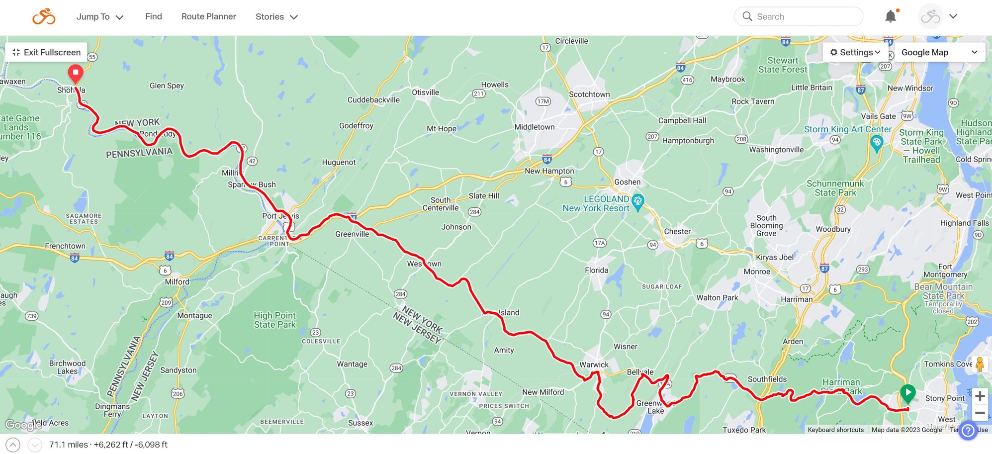
OK T-Party, I had some time this afternoon so I subscribed to RideWithGPS and planned a route. FYI, it's $9.99/month for the paid version or you can use the free version, but I think only the paid version gives you speaking turn-by-turn directions. It's $9.99/month and you can cancel any time. Tip: Our ride IS LESS THAN A MONTH AWAY, so you can sign up now and cancel after the ride.
Route B (FROM ABOVE)
Here's a suggestion, if we want to push to Hawk's nest, we can remove two loops as shown below. This removes about 30 miles of slow roads, so likely 45-60 minutes of drive time. UPDATED ROUTE ALL THE WAY TO THE END (BEGINNING) OF HAWK'S NEST, OUR TURNAROUND POINT.
I personally would not remove the Greenwood Lake loop. I would rather spend more time driving then parked. But that's just me and I am flexible and go with the flow. If we are starting early enough in the day, we can do the lake loop and then at the spot in Warwick, guys can decide to head west to Hawks Nest or venture home. Many people will be in a new area and it would be nice to show off our good roads to them!
I personally would not remove the Greenwood Lake loop. I would rather spend more time driivng then parked. But that's just me and I am flexible and go with the flow. If we are starting early enough in the day, we can do the lake loop and then at the spot in Warwick, guys can decide to head west to Hawks Nest or venture home. Many people will be in a new area and it would be nice to show off our good roads to them!
I'm good with that. Flexible. Was the loop around the lake I originally mapped the right path to take?
Originally Posted by DSC48
Oh and I suggest everyone bring a FRS radio with them for communication purposes.
Agreed! I just bought new ones, and after doing some research online, I bought these as a great balance of performance and price:
I've been doing some more map-exploring and it looks like our turnaround point, at the furthest, is Barryville, NY. From there, unless traffic dictates otherwise, we can reverse it and drive the Hawk's Nest run again. After all, I'm sure many of us won't be up that way for a long time. For me, it's over 2.5 hours home. It's 4 hours to Boston from there.
Oh, and BTW, I think we may need to officially change the name of this thread and event to: The 911T-Party Meet up & Hawk's Nest Run. All in favor? If so, we'll ask the @moderator to change it.
Stayin Alive Trying to close mega deal before T meet�.New Yawk way�.meaning working round the clock. I say don�t mess with thread name since we�ll be starting meet in the general area of Bear Mtn�.close enough. Regarding driving route, been everywhere there and I�m good with whatever group wants to do. Final version map shared here would be good however
UDPATED TO SHOW WHAT I THINK IS OUR BETTER TREK, WHICH IS TO MAKE IT TO HAWK'S NEST:
OK T-Party, I had some time this afternoon so I subscribed to RideWithGPS and planned a route. FYI, it's $9.99/month for the paid version or you can use the free version, but I think only the paid version gives you speaking turn-by-turn directions. It's $9.99/month and you can cancel any time. Tip: Our ride IS LESS THAN A MONTH AWAY, so you can sign up now and cancel after the ride.
Route B (FROM ABOVE)
Here's a suggestion, if we want to push to Hawk's nest, we can remove two loops as shown below. This removes about 30 miles of slow roads, so likely 45-60 minutes of drive time. UPDATED ROUTE ALL THE WAY TO THE END (BEGINNING) OF HAWK'S NEST, OUR TURNAROUND POINT.
so my .02 cents with this app�.. kinda wish there was a way to sync it with CarPlay �� I absolutely suggest being we can all get wifi in our cars that we do so . I lost service on a drive last month and it basically over for me
so my .02 cents with this app�.. kinda wish there was a way to sync it with CarPlay �� I absolutely suggest being we can all get wifi in our cars that we do so . I lost service on a drive last month and it basically over for me
Here's what I do:
I use google maps
Lay out the route using "destination" points along the way to ensure that google doesn't tweak the route in real time
Pre-load offline maps of the area into google maps shortly before the event; this enables the app to use satellite location to keep me on the route even if I lose cell signal
I typically lay out the route on a bigger screen -- laptop or desktop machine -- for convenience. This method will produce a link to the exact route I laid out, which I can then send to whatever device will be stuck to my dash during the drive. If I had Apple CarPlay it could then be displayed on the car's infotainment screen.


 08-13-2023, 10:17 PM


 Trying to close mega deal before T meet�.New Yawk way�.meaning working round the clock. I say don�t mess with thread name since we�ll be starting meet in the general area of Bear Mtn�.close enough. Regarding driving route, been everywhere there and I�m good with whatever group wants to do. Final version map shared here would be good however