
SHARKS IN THE MOUNTAINS 2010 - 928 Specialists 13th Annual 928 Event - June 4th-6th
 05-17-2010, 05:15 PM
#316
Addict
Lifetime Rennlist
Member
Lifetime Rennlist
Member
Not sure what time the Detroit crew is heading out, yet. I suspect it'll be in the morning with arrival in Alcoa somewhere around 6-7PM - maybe a bit earlier.
Time and weather permitting (I supposed raod closures too) we'll hit the Dragon on Thursday evening, followed by dinner and a few libations.
Time and weather permitting (I supposed raod closures too) we'll hit the Dragon on Thursday evening, followed by dinner and a few libations.
what time you heading out friday AM?
 05-17-2010, 06:28 PM
#317
Supercharged
Rennlist Member
Rennlist Member
Join Date: May 2002
Location: Back in Michigan - Full time!
Posts: 18,925
Likes: 0
Received 60 Likes
on
34 Posts
 .
.Left you a VM. Call me anytime tonight.
05-17-2010, 11:12 PM
#318
Rest in Peace
Rennlist Member
Rennlist Member
Join Date: May 2006
Location: Bird lover in Sharpsburg
Posts: 9,903
Likes: 0
Received 2 Likes
on
2 Posts
Are you folks that are meeting in Alcoa going to be taking to full BRP route to Banner Elk?
I would like to know your route as I may leave a day early to drive that with you bunch of yankees.
I would like to know your route as I may leave a day early to drive that with you bunch of yankees.
05-18-2010, 01:15 AM
#319
Supercharged
Rennlist Member
Rennlist Member
Join Date: May 2002
Location: Back in Michigan - Full time!
Posts: 18,925
Likes: 0
Received 60 Likes
on
34 Posts
 05-18-2010, 09:57 PM
#320
Rest in Peace
Rennlist Member
Rennlist Member
Join Date: May 2006
Location: Bird lover in Sharpsburg
Posts: 9,903
Likes: 0
Received 2 Likes
on
2 Posts
I have been trying for days to post a link from MapSource.
Getting closer.
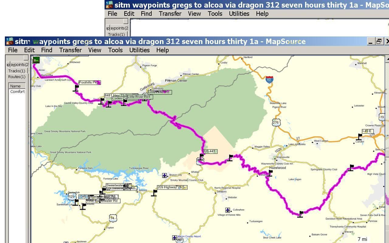
This one goes from Alcoa to Cades Cove road in the park, then to Little River road, then to the Blue Ridge Parkway.
The little River road is one of the best roads i have ever driven, better than any in the Rockies, IIRC this is the road that had the corner sign that looked like a 0.
Getting closer.
This one goes from Alcoa to Cades Cove road in the park, then to Little River road, then to the Blue Ridge Parkway.
The little River road is one of the best roads i have ever driven, better than any in the Rockies, IIRC this is the road that had the corner sign that looked like a 0.
05-18-2010, 10:04 PM
#321
Supercharged
Rennlist Member
Rennlist Member
Join Date: May 2002
Location: Back in Michigan - Full time!
Posts: 18,925
Likes: 0
Received 60 Likes
on
34 Posts
BRP is way too tame IMO. What that road on your first map just below the Smoky Mountain National Forest that ends up near Hazelwood? That looks fun. My route would take us right near that.
05-20-2010, 05:03 PM
#323
Drifting
New Garmin GPS in route via UPS courteous of my company for 15 years of my life.
Andrew, do you know if there is a way to download the way points via usb cable.
I'd like to get this preprogrammed incase I can't keep up.
Andrew, do you know if there is a way to download the way points via usb cable.
I'd like to get this preprogrammed incase I can't keep up.
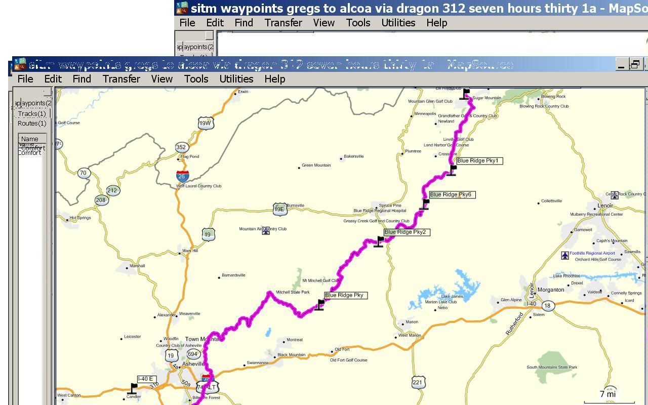
Here's the route I've got planned. A wicked fun route! I've taken time to hopefully find addresses that you pop into your GPS. Alternatively, you can pull the route up on this Google Maps - http://tinyurl.com/24nnsg8
05-20-2010, 05:20 PM
#324
Rest in Peace
Rennlist Member
Rennlist Member
Join Date: May 2006
Location: Bird lover in Sharpsburg
Posts: 9,903
Likes: 0
Received 2 Likes
on
2 Posts
If I make Alcoa I will have my laptop with routes on it so you can load to your Garmin if you do not have MapSource.
Per my conversation with Garmin yesterday there is no way to post pictures on the internet straight off of MapSource
05-20-2010, 06:05 PM
#325
Chronic Tool Dropper
Lifetime Rennlist
Member
Lifetime Rennlist
Member

Kurt--
Manually adding these places as waypoints won't take long, but you may find that the 255W doesn't hold that many as one trip sequence. You'll probably choose the first point as a single destination, and then select the next place as a destination after you arrive. With all of the point preloaded as 'Favorites' you'll be selecting them from a list rathr than typing them in again on the side of the road. If that MapSource app isn't expensive and you carry a laptop or netbook with you, it might be fun to play with. But not while you are driving...
** Looks like the software is under $25 at places like Office Depot stores.
05-20-2010, 06:14 PM
#326
Chronic Tool Dropper
Lifetime Rennlist
Member
Lifetime Rennlist
Member
The Google source that AO shared allows me to see that I'm a mere 12.5 rental car driving hrs from the event if I end up where I'm supposed to be. Guess I need to put that BW on speed dial.
05-21-2010, 09:51 AM
#327
Supercharged
Rennlist Member
Rennlist Member
Join Date: May 2002
Location: Back in Michigan - Full time!
Posts: 18,925
Likes: 0
Received 60 Likes
on
34 Posts
What I do for programming on the Garmin is I enter all the addresses into the GPS, name them SITM WPA, SITM WPB, etc, and save them. Then it's just a matter of recalling them. Shouldn't take more than a few minutes to program all those WP in.
The GPS that's integrated into my headunit has route programming and it worked pretty good last year. I plan on doing the same this year.
Dr. Bob. If you could make it, that sure would be cool.
The GPS that's integrated into my headunit has route programming and it worked pretty good last year. I plan on doing the same this year.
Dr. Bob. If you could make it, that sure would be cool.
05-21-2010, 06:05 PM
#329
Rest in Peace
Rennlist Member
Rennlist Member
Join Date: May 2006
Location: Bird lover in Sharpsburg
Posts: 9,903
Likes: 0
Received 2 Likes
on
2 Posts
Tick Tock, two weeks way.
If any one wants the *.GDB file of Andrews route to load into a Garmin GPS send me a PM with your e-mail address.
It looks like 298 miles and MapSource is saying seven hours and twenty eight minutes for it, that is a average of almost 40 MPH, gonna be tough to make that on those twisty mountain roads.
Dr Bob, I also hope you can make it.
To my friend Paul, you better get your *** to work or you are not going to make it in your 928.
