Notices

Would anyone find this useful?

Thread Tools
 
Search this Thread
 
Old 03-08-2018, 04:08 PM
  #1  
gtreddy
Instructor
Thread Starter
 
gtreddy's Avatar
 
Join Date: Jul 2016
Location: Houston, TX
Posts: 174
Received 24 Likes on 18 Posts
Default Would anyone find this useful?

Hey guys/gals,

I got back from COTA and decided to throw together a quick program that might be simple and easy to glean some info on. I created a small app (it's very raw, just to see if the use is helpful) and wanted to get your opinion. Basically you just select the export file from whatever data logger you're using and it generates a kind of interactive map. This example just shows throttle position with brake force.

If you think something simple like this that generates an automatic view like this is useful, let me know, and I might develop it further with a gui for others to use it.

Here is the image of what it kind of creates. The video below shows the interactivity component. Note, its very raw and just a concept at the moment.


Video Link:
Old 03-08-2018, 04:16 PM
  #2  
Matt Romanowski
Rennlist Hoonigan
which cost no drachmas
Lifetime Rennlist
Member


Rennlist
Site Sponsor
 
Matt Romanowski's Avatar
 
Join Date: Dec 2001
Location: Manchester, NH
Posts: 12,683
Received 1,005 Likes on 600 Posts
Default

Didn't look at the video but I think it's great!
Old 03-08-2018, 05:01 PM
  #3  
ProCoach
Rennlist
Basic Site Sponsor
 
ProCoach's Avatar
 
Join Date: Jun 2008
Location: Durham, NC and Virginia International Raceway
Posts: 19,157
Received 3,340 Likes on 1,895 Posts
Default

This visualization is the next step to allow users to assimilate the most important information in the quickest, easiest and most "sticky" way.

Great work, looking forward to seeing more.
__________________
-Peter Krause
www.peterkrause.net
www.gofasternow.com
"Combining the Art and Science of Driving Fast!"
Specializing in Professional, Private Driver Performance Evaluation and Optimization
Consultation Available Remotely and at VIRginia International Raceway


Old 03-08-2018, 05:18 PM
  #4  
gtreddy
Instructor
Thread Starter
 
gtreddy's Avatar
 
Join Date: Jul 2016
Location: Houston, TX
Posts: 174
Received 24 Likes on 18 Posts
Default

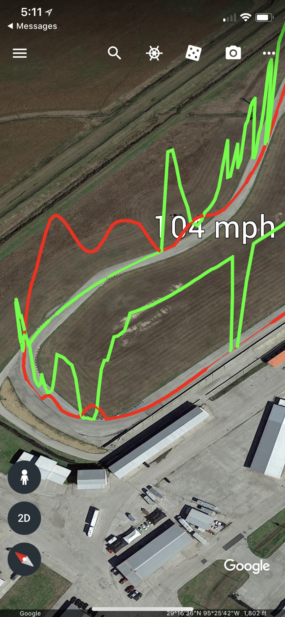
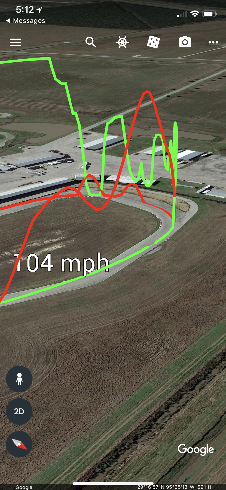
Thanks guys, was able to port it over to create a kmz file because google earth has a better dynamic interface. That might be the best future solution. Take about 10 seconds to convert the data input into a kmz that displays this.. The second one is just kinda for fun.


Old 03-08-2018, 05:35 PM
  #5  
Juan Lopez
Addict
Rennlist Member

 
Juan Lopez's Avatar
 
Join Date: Mar 2002
Location: Ft. Lauderdale, FL
Posts: 2,753
Received 59 Likes on 37 Posts
Default

i would use it
Old 03-08-2018, 05:55 PM
  #6  
TXE36
Drifting
 
TXE36's Avatar
 
Join Date: Feb 2013
Location: TX
Posts: 2,943
Received 191 Likes on 128 Posts
Default

That is cool. I'm familiar with those tracks and was able to interpret them instantly. Hella useful.

-Mike
Old 03-08-2018, 06:01 PM
  #7  
ShakeNBake
Rennlist Member
 
ShakeNBake's Avatar
 
Join Date: Mar 2009
Posts: 5,660
Received 961 Likes on 555 Posts
Default

That is very cool !
Old 03-08-2018, 06:28 PM
  #8  
mglobe
The Penguin King
Rennlist Member
 
mglobe's Avatar
 
Join Date: Apr 2006
Location: Houston
Posts: 9,834
Received 118 Likes on 84 Posts
Default

Is it going to do lap overlays?
Old 03-08-2018, 07:14 PM
  #9  
gtreddy
Instructor
Thread Starter
 
gtreddy's Avatar
 
Join Date: Jul 2016
Location: Houston, TX
Posts: 174
Received 24 Likes on 18 Posts
Default

Originally Posted by mglobe
Is it going to do lap overlays?
Currently yes/no, however it wouldn't take any time at all to implement. It's literally just calling the same function again and exporting.

However using the KMZ output to google earth, the google earth app can handle the lap comparisons as is. So, it depends on how, I want to handle the files. I just need to handle the colors to make it less confusing. Meaning I would probably limit it to a 2 lap comparison, because I feel the amount of data would then cross over to the confusing for most people and the whole aim of this was simple useful visualization.

The following can already be done, just need to change colors..


What's really nice is that i can just open the kmz file on my iphone and view it on there...


Old 03-08-2018, 07:17 PM
  #10  
gtreddy
Instructor
Thread Starter
 
gtreddy's Avatar
 
Join Date: Jul 2016
Location: Houston, TX
Posts: 174
Received 24 Likes on 18 Posts
Default

Like, I said it's all raw so it's not perfect. I haven't worked on it much at all. But I'm open to constructive feedback on things that would add value.
Old 03-08-2018, 08:11 PM
  #11  
Thundermoose
Burning Brakes
 
Thundermoose's Avatar
 
Join Date: Jan 2011
Posts: 1,105
Received 103 Likes on 72 Posts
Default

I think it looks great!
Old 03-09-2018, 01:24 AM
  #12  
Ubermensch
Rennlist Member
 
Ubermensch's Avatar
 
Join Date: May 2005
Posts: 2,136
Received 177 Likes on 118 Posts
Default

I'm with everyone else. That looks really helpful and I'd definitely use it.
Old 03-09-2018, 09:25 AM
  #13  
ProCoach
Rennlist
Basic Site Sponsor
 
ProCoach's Avatar
 
Join Date: Jun 2008
Location: Durham, NC and Virginia International Raceway
Posts: 19,157
Received 3,340 Likes on 1,895 Posts
Default

There are many great ways to visualize what you're doing where. Pretty cool stuff, gtreddy!

Old 03-09-2018, 09:35 AM
  #14  
tedean
Racer
 
tedean's Avatar
 
Join Date: Dec 2008
Location: Colorado
Posts: 322
Received 3 Likes on 2 Posts
Default

That is impressive and of course very visual. Great teaching tool.
Old 03-13-2018, 01:43 PM
  #15  
aryork
Rennlist Member
 
aryork's Avatar
 
Join Date: Sep 2016
Location: where it gets hot in summer
Posts: 973
Received 173 Likes on 96 Posts
Default

Looks super useful! Keep it coming!


Quick Reply: Would anyone find this useful?


All times are GMT -3. The time now is 10:56 PM.