When you click on links to various merchants on this site and make a purchase, this can result in this site earning a commission. Affiliate programs and affiliations include, but are not limited to, the eBay Partner Network.
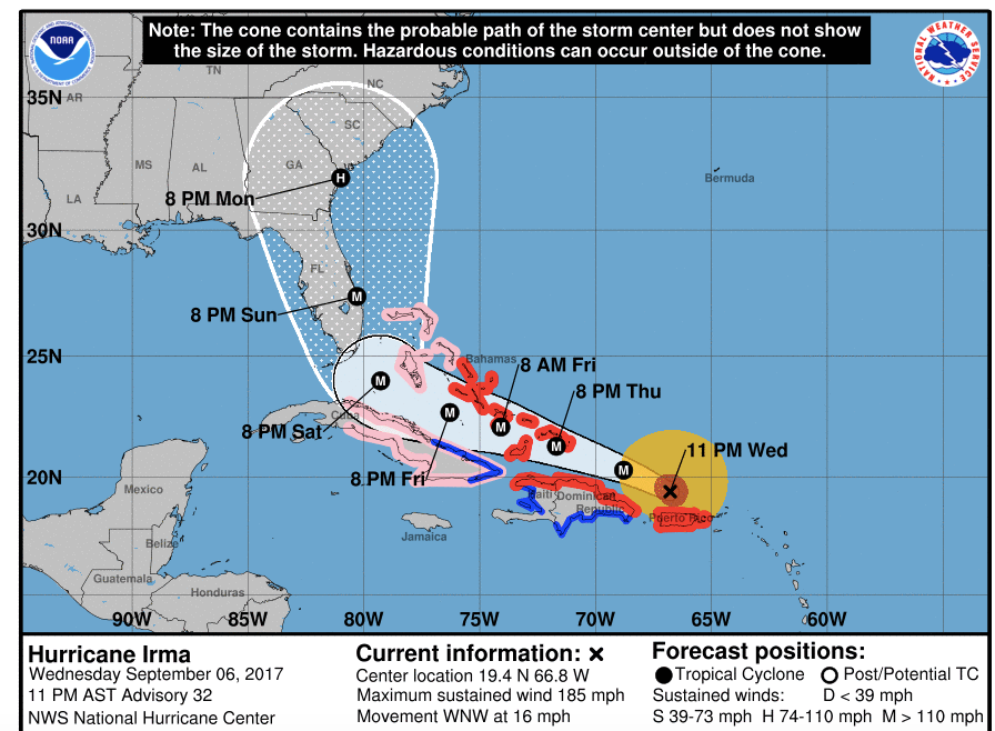
Here's the 11:00 PM 9/6/17 forecast based on the latest model runs. Not much has changed since the 5 PM runs. Increasingly, it looks like Miami is in trouble. Hope people get out.
The cable news has become Irma 24/7, and the GFS model has moved to the west and now coincides with the European model. From here on out the track should remain mostly unchanged from one model run/forecast to the next. When both models show identical tracks there's about 90% certainty of the point of landfall..+/- 15-20 miles (which is silly to consider because Irma is about twice the size of Andrew...huge areas will get up to F4 tornado-like damage). So...this will be my last update as Irma is transitioning from a prediction to reality.
That graphic is eerily similar to what was in the movie! Now we see on CNN that there are major fuel shortages in Florida and stores are being rapidly emptied of critical supplies.
If this storm picks up further energy over "hot" waters it seems we could be talking about unprecedented cataclysmic damage. Hopefully not the case but it is looking very ominous at the moment.
That there are three storm systems active concurrently, although not unprecedented, is kind of
Lower graphic is from the movie. Someone saw the resemblance. Yes..all meteorology discussions on NOAA are saying Irma has ideal conditions all the way to Florida and could intensify. Turks and Caicos just got the eye wall on the NE side. 20 ft storm surge and 175 mph winds.
Originally Posted by FredR
That graphic is eerily similar to what was in the movie! Now we see on CNN that there are major fuel shortages in Florida and stores are being rapidly emptied of critical supplies.
If this storm picks up further energy over "hot" waters it seems we could be talking about unprecedented cataclysmic damage. Hopefully not the case but it is looking very ominous at the moment.
That there are three storm systems active concurrently, although not unprecedented, is kind of
I do not know if the fact that there are three systems running concurrently has any significance but if somehow they can link up and in effect supercharge each other now such could be truly worrisome.
Makes one wonder just how much of the movie was science fiction and how much was based on speculative but well informed technical opinion.
We have had a couple of hurricanes hit Oman in the last decade - not the kind of thing anyone living here ever expected and they were quite something- just not on the scale we are seeing in your neck of the woods.
There is a small amount of good science in the movie. The part about disrupting the great oceanic conveyor belt current is real science. The part about air bubbles (fossil air from way back in the last ice age) in ice cores with lower CO2 gas content than present atmosphere is real science. Freeze drying helicopter pilots with some not-going-to-happen super cold down draft in the eye - NO. Three storms is unusual, but it's happened in the pacific not long ago. The storms won't link up. They are distinct entities that create very unique air flow around them. If you go here you can watch it.
There is indeed a phenomenon called the Fujiwara Effect (sounds like a Robert Ludlum novel lol) where two tropical cyclones can begin to orbit around a central point, and even collapse into each other, forming a single storm. These storms are too far apart however (at least, Irma and Jose are, I haven't paid any attention to whatever the third thing is).
Originally Posted by FredR
I do not know if the fact that there are three systems running concurrently has any significance but if somehow they can link up and in effect supercharge each other now such could be truly worrisome.
Makes one wonder just how much of the movie was science fiction and how much was based on speculative but well informed technical opinion.
We have had a couple of hurricanes hit Oman in the last decade - not the kind of thing anyone living here ever expected and they were quite something- just not on the scale we are seeing in your neck of the woods.
Very interesting. I knew extratropical lows converge (or one transfers energy to a deeper low). Learned something new...wonder if this effect is more common in the Pacific where storms can exist for longer and start the binary circulation and convergence until they merge.
Originally Posted by bureau13
There is indeed a phenomenon called the Fujiwara Effect (sounds like a Robert Ludlum novel lol) where two tropical cyclones can begin to orbit around a central point, and even collapse into each other, forming a single storm. These storms are too far apart however (at least, Irma and Jose are, I haven't paid any attention to whatever the third thing is).
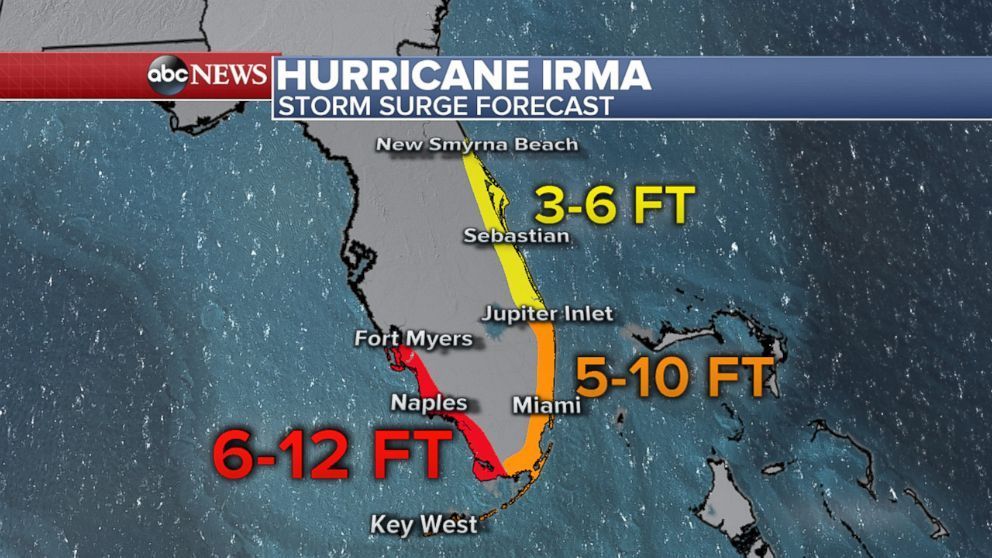
The currently predicted storm surge on the west coast is rather alarming. I have been watching CNN this afternoon and they seem to predicting about 10 feet in areas like Port Charlotte. If correct such could be devastating given the topography seems very flat and not much above sea level at all. Indeed it kind of looks as though much of the land around there may be reclaimed and storm surges are not too kind to locales like that.
Looking like Miami has dodged the worst of the winds and may see max sustained winds under 90 mph. However, Tampa looks to be in trouble. It's actually one of the cities most at risk of catastrophic damage from a hurricane storm surge. The west coast of Florida has shallow waters for miles off shore, so the storm surge is "ramped" up over this shallow shoal and has nowhere to go but up. This is more an effect of the bathymetry of the Gulf side of Florida than the storm itself.
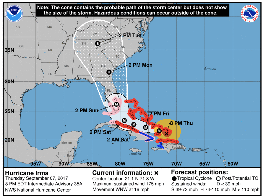
Irma has been weakened while the eye has been scraping the northern coast of Cuba. Soon it will be in the warmest open waters as it crosses the Florida Straits, and could intensify again.
Storms surge is still significant for both sides of southern Florida. It's important to note that there will be huge waves on top of the storm surge. So a 10 foot above mean sea-level storm surge plus 10 to 15 foot waves is a whole lot more scary.
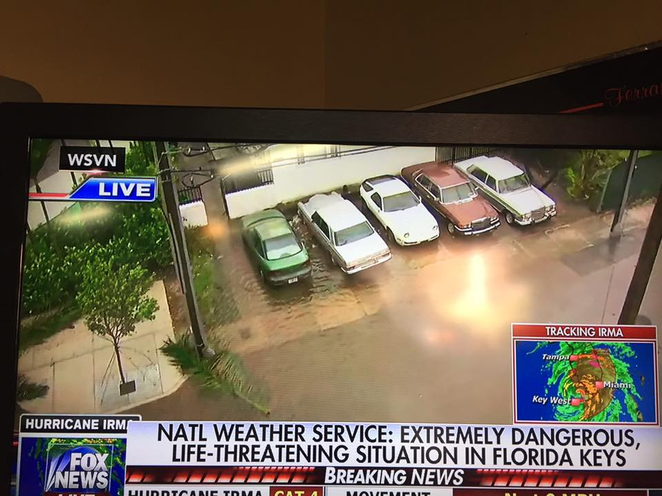
Heard an interview between Don Lemon (CNN) and a father of a family of four who decided to ride it out in the Keys. Immediately after the interview the meteorologist at the National Hurricane Center was interviewed and Don asked about this decision to ride it out. The meteorologist, in an unemotional deadpan tone said "they likely won't make it." The mayor of Key West said the storm surge will likely alter the geography of the Keys permanently, with little to return to. It was the most dire and sobering language I'd heard so far. I think this comment was based on the assumption that Irma is a Cat4/5 when striking the Keys.
Last edited by Captain_Slow; 09-09-2017 at 03:23 PM.
Just watching coverage on CNN from Naples - quite incredible scenes.
I sure hope folks heeded the Government warnings and this before the storm surge hits. I suspect an awful lot of residential property and infrastructure is going to be trashed

 09-07-2017, 12:25 AM