When you click on links to various merchants on this site and make a purchase, this can result in this site earning a commission. Affiliate programs and affiliations include, but are not limited to, the eBay Partner Network.
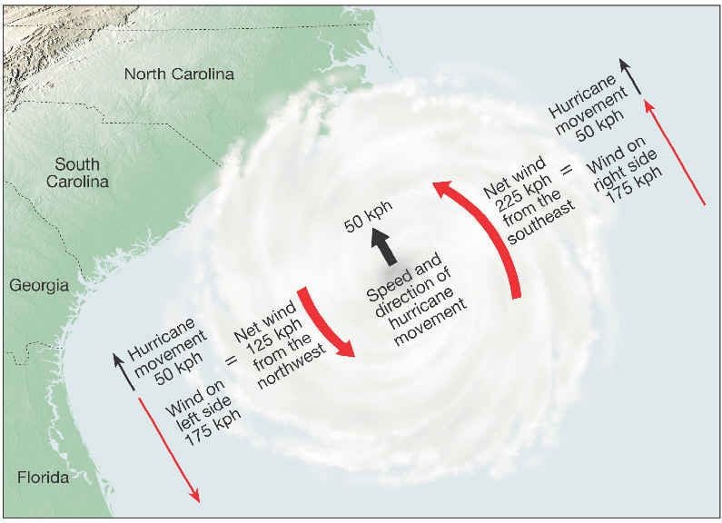
The National Hurricane Center has adopted the European model's predicted track for Irma, now a Cat 4 storm, with favorable conditions for intensification ahead. Yes, this is still more than a week away, but I'm posting this because the European model has been incredibly accurate, even 6-7 days out, since the early 2000s. It predicted Katrina, Sandy, and Harvey, and others perfectly. One thing to note is this storm is moving pretty fast and could be more powerful. So the rain totals will be lower, but the storm surge and wind damage near the coast would be greater. At landfall, wind speeds to the northeast/east of the eye will be ONSHORE and highest (speed of storm rotation PLUS the linear speed of the storm moving along its path) and highest storm surge. Southwest/west of the eye will have lower winds (rotating winds MINUS linear speed of the storm along its path) and much less storm surge due to winds blowing OFFSHORE in this quadrant. This information is most helpful when trying to decided which way to "run" for safety. Generally, heading west of the eye is better.
A few days ago the North American and European models were showing different tracks about 4 days out. Now they are showing nearly identical tracks, and show Irma taking a turn straight north on Saturday/Sunday into the tip of Florida. When the two most reliable computer models yield nearly identical tracks...it's almost a certainty, plus or minus some variations in the landfall location for the eye. But it's important to remember hurricanes are not points...the right/east side of the eye will have the worst of everything. Because Irma will not likely go into the Gulf, landfall isn't more than a week away...it's about 5-ish days away.
Go here: https://www.wunderground.com/wundermap Turn off all the weather stations. Drag the map to show Florida and western Atlantic. Check the box for models. ECMWF should be checked (European model). Click play on the time slider on the map...and watch not only the track but the intensification. Scary.
Last edited by Captain_Slow; 09-05-2017 at 08:35 PM.
The gulf is an overheated hot-tub these days, ready to feed energy into any storm that wanders in. Almost any significant depression feeds itself with the heat of the water and gets deeper. Global warming will be somewhat self-solving as all those gulf-coast refineries and drilling platforms are flooded. Anybody else wonder why we build a Keystone/Excel pipeline to carry crude to gulf coast refineries, then put the results into other pipelines back north?
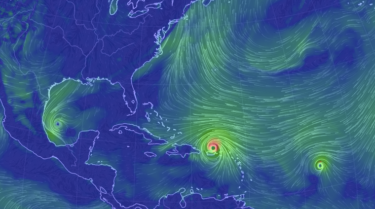
Holy moly !!! It looks like there's another one after it too ... hopefully that doesn't follow the same pattern.
Don't be surprised if it does follow a similar path. Storms follow the warm water. At times the storms almost seem intelligent, but it's just the way things work out when strengthening only happens over warm water...it self corrects like train wheels staying on rails. Tracks deviate from the location of warm water when upper level steering winds (the Jet Stream and prevailing westerlies) turn the storms toward the NE. Storms can die if there is "sheer" in the atmosphere, resulting from really fast upper level winds disrupting convective cycling within the eye wall and surrounding bands. So far conditions are perfect...for Irma.
Purple is really warm...lots of energy for the storms. Deeper than normal warm layer (shhh...we won't talk about why) means there's ample energy to form additional storms...strong ones. Instead of storms stirring up cooler waters and transferring enough energy from ocean to atmosphere to hinder future storms, these storms are mostly just stirring up deep warm water. 80 meters used to be typical warm water depth. Typhoon Haiyan (the storm that "broke the scale"...some calling it category 6) that hit Philippines a few years ago rode over water temperatures adequate to fuel a typhoon (hurricane) 200 m down! There was almost no noticeable ocean cooling after it passed. Just way more energy in the oceans than modern humans have ever had to live with.
The water temp in the green circle is 88+ degrees, considered dangerous for snorkeling or SCUBA diving...the exertion of swimming would lead to heat exhaustion/stroke, and dehydration from sweating with no cooling effect.
The Gulf stream could play a role in fueling Irma up the coast.
National Hurricane Center has clearly adopted the European model...which currently has Irma slamming Cuba then heading north into the Everglades, then right up the center of Florida. The GFS is the North American model. Not favored, but the track is right over the warm Gulf Stream and up the eastern shore of Florida.
As of about 6:00 PM ET 9/5/17 this is close to the predicted landfall...Note...everything to the EAST of the eye will be HAMMERED by extreme winds, storm surge. Interestingly, the Everglades are about to demonstrate why it's smarter to not develop coastlines. The mangroves and other native plants are the result of tens of thousands of years of hurricane/tropical storm natural selection since at least the end of the last Ice Age.
Last edited by Captain_Slow; 09-05-2017 at 11:23 PM.
Anyone trying to get a flight out will need some luck. I spent 3 hrs on the phone last night with various airlines, finally got a seat on Jet Blue for Thursday, Orlando to Albany for my Nephew.
Road trip tomorrow in the 928 to pick him up in Albany.
It looks at the moment like it's headed right for me. I'm not going anywhere (if I did, that's where the storm would end up, that's just the way it is) but I do know some folks are fleeing. South Florida is probably one of the most prepared areas in the country for this type of thing though, given history and it's impact on building codes, etc. Let's hope I don't eat my words...
I think I'm going to stash the shark in a large concrete parking garage, if I can find an open one close.
I just had dinner with a bunch of my JMU GIS colleagues. One of them (Ryan Miller) is a weekend TV meteorologist for ABC 7 - WJLA (Wash. D.C.) The cold front that passed through the mid-Atlantic yesterday helped nudge the track a bit to the east. The low pressure associated with the cold front is lifting to the north, and the cold front is fading fast. He says there are no significant upper level steering winds and riding up the coast of Florida Irma will have ample warm waters (Gulf Stream) to fuel it right up into South Carolina. High pressure building in the Northeast, will deflect Irma inland to the Ohio River valley where it will become extratropical and fizzle. So...I expect the models to be converging more tightly from now on, and expect the track to change less with each successive model run (every 6 hours...5 am, 11 am, 5 pm, etc....each just before the morning, afternoon, and evening TV weather forecasts). Right now I'm waiting to see the 11 pm (ET) model results.
Earlier today another named tropical storm formed in the Gulf...though seems weaker now. Something to keep an eye on. The link below will take you to an impressive wind field model. It pulls in data from buoys, ships, satellites, and animates it.

 09-04-2017, 09:31 PM