When you click on links to various merchants on this site and make a purchase, this can result in this site earning a commission. Affiliate programs and affiliations include, but are not limited to, the eBay Partner Network.
This is probably the best design I've seen thus far for cup holding solutions. I would love an option like that but capable to hold a Yeti 64oz. Thanks for sharing this one, I might look into it for regular sized cups. I almost never drink beverages in the 992, but I'm always carrying water.
This is probably the best design I've seen thus far for cup holding solutions. I would love an option like that but capable to hold a Yeti 64oz. Thanks for sharing this one, I might look into it for regular sized cups. I almost never drink beverages in the 992, but I'm always carrying water.
More like what I did with my 992 over the last few days! My Carrera T Cab was delivered to Napleton Porsche Westmont in the Chicagoland area about a week ago. I had it transported to Lustr detail in Palatine, IL, about 28 miles from the dealership for PPF, ceramic, a wheels off detail and ceramic coat and window tint. They got the car a week ago Tuesday and started on it on Wednesday of that week. In the mean time I planned my trip out to Chicago to pick it up and drive it back to the Atlanta area, the long way to be able to enjoy and bond with the car. I flew into Chicago last Sunday and planned to stay with a college buddy for a couple of days until it was ready to pick up. I ended up getting it Tuesday afternoon. The car looked great! Ivan did a fantastic job and I highly recommend Lustr. Here are some pics from the pick-up.
That night I was able to install a bunch parts for the trip like a Blendmount and Mirror Tap for my Uniden R8, the Rennline powered phone mount, TLG guards and a few other things.
The next morning I was ready to hit the road. The plan was to head down through Indy to Louisville via I-65, with a brief stop In West Layette to swing through the Purdue campus, and then venture on backroads down to the Knoxville area to get in some driving there before heading home. I ended up stopping in Louisville for dinner. I hit Proof on Main Street- the food was fantastic! I got back on the road and made it down to Elizabethtown, KY before calling it quits for the day.
That night I revised my plan and this is what I drew up. I should also say one of the reasons I wanted to make this post was to share a couple of these routes so others could enjoy them, so I'll also link the .GPX file so you could pull them in to your nav app. I should also say I experimented with Scenic, after knowing I wasn't happy with Google MyMaps since the routes you save don't allow turn-by-turn nav. Scenic was actually very good. And I'd recommend it. It will import and export .GPX files, which are standard for navigation, again Google does not.
Sorry, back to the route through the rest of Kentucky. Here is the link to the GPX file. This route was awesome! Some of the most beautiful areas of rural Kentucky you will see. All kinds and types of roads, elevation changes, speed/gearing. I will run this one again, maybe in the other direction!
I got down to Maryville, TN, just south of Knoxville, where I was staying, grabbed some lunch and took off on a round-robin plan down the Tail of the Dragon (US 129), through Robbinsville, NC, across NC-143 to NC-28 otherwise known as the Moonshiner 28, which puts you right back on the Dragon at Deals Gap heading northbound and back up 129 and TN-336 to Maryville where I was staying at the RT Lodge. The RT Lodge sits on a wooded, secluded part of the Maryville College campus- you feel like you are actually out in the woods there! It has a great restaurant and cool rooms. A great place for a weekend get-away.
The driving in this area is phenomenal. This route puts you on a few of them. I've done a couple of the Rennsport Dragon Rallies in that area in the past, which are three days of full out driving. Every road you hit, you could swear was better than the last. Here is the link to the .GPX file.
Photographers stake out areas along the Dragon and a couple of other roads. You can search for your car by day/time block and download the photos. Here are a couple of my run south and then north bound.
The next morning I kinda free-wheeled it home hitting GA-60 which is a fantastic road, then down US19, which is a a little faster than some of the tighter backroads in north Georgia.
I was able to take some GoPro video running in KY, TN and NC on the second day. Here is a short 5 min compilation of that leg of the trip.
Had to post this here as well, forgive my lazy summer Sunday regalia...but just because i am so proud that I did it myself and that something like this is available to us north americans cabriolet/targa owners. Albeit I had the help of my invaluable 17 year old who took a break from studying for her SATs to hold the cover back while eI access teh harness and held a flashlight for me, and would encourage with yeses and "no no no no no, not like that DAD!!!".
Took exactly 20 minutes, thanks to properly reading instructions pre-game, the advice in the forum and BobbyGFL video on youtube, (and always having right tools on hand, T25 ratchet screwdriver and a couple of trim tools)
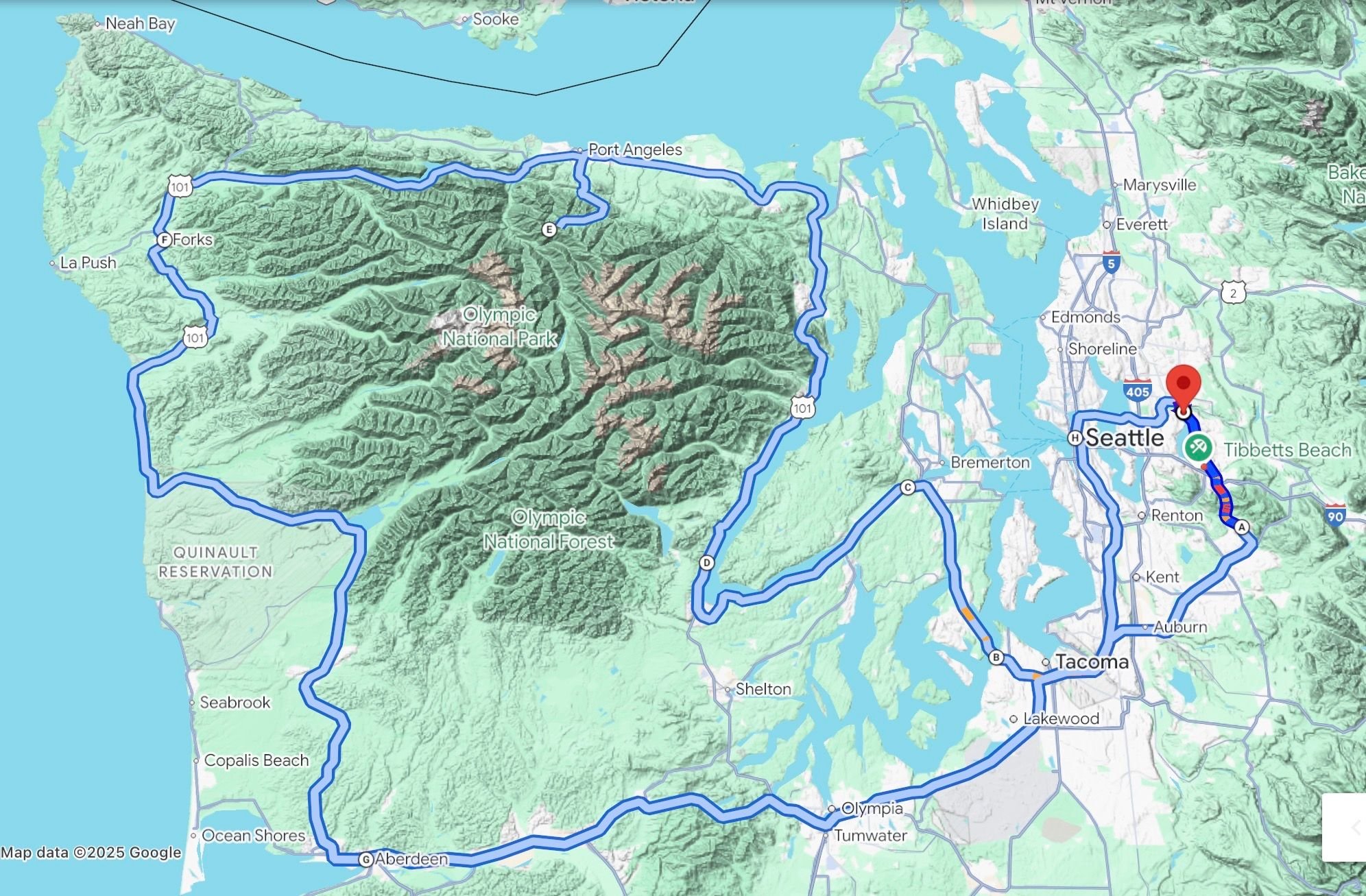
I went on a 525 miles (845 km) one-day drive on famous highway 101 (US Route 101) around Olympic National Park in Washington State. Starting early near Lake Sammamish east of Seattle, I first drove south and crossed the Puget Sound via the Tacoma Narrows Bridge, then turning north along Hood Canal, a fjord-like body of water extending southwards for about 50 miles (80 km). For miles and miles, the road clings to its coastline. While the posted speed limit is 40 Mph, traffic flowed generally 10-15 Mph above through sweeping curves and up and down smaller hills.
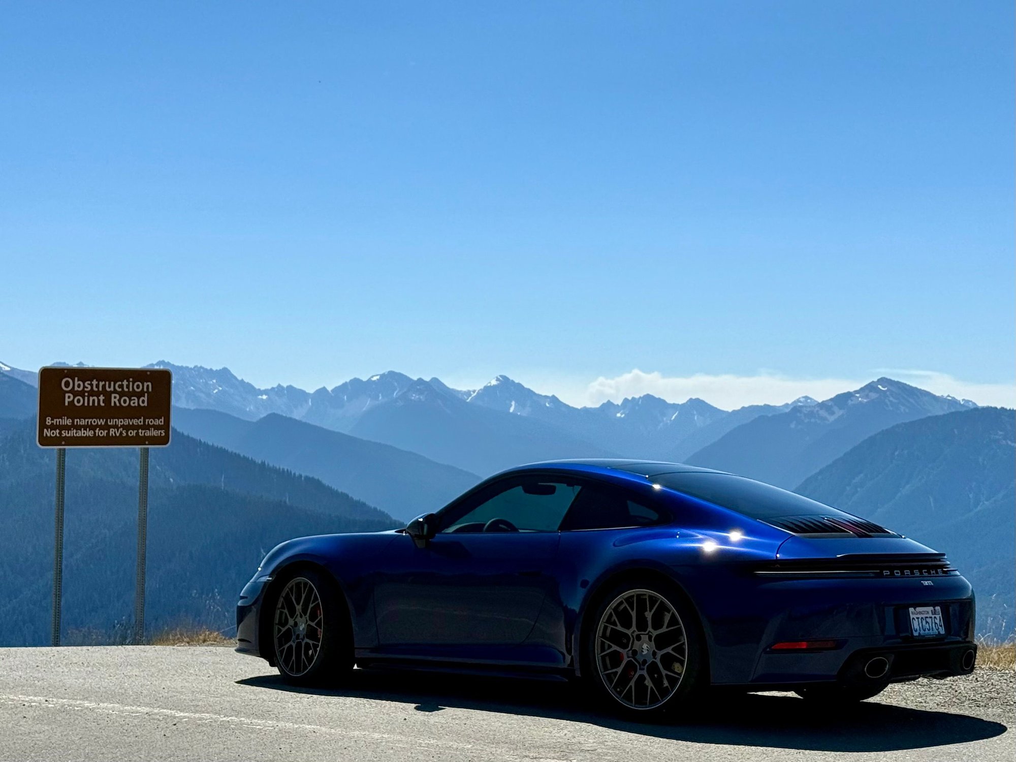
In Port Angeles, situated at the shore of the Strait of Juan de Fuca on the norther edge of the Olympic Peninsula, I left Route 101 and drove about 18 miles south into the National Park to Hurricane Ridge (elevation of 5,242 feet or 1,598 m) for an hour or so of hiking. At this time of the year, the ridge is a somewhat overrun tourist attraction. Many people don’t leave the parking lot, some not even their cars. It offers amazing views over the Olympic Mountains. Sadly, the visitor center burned down a few years ago.
Back on Route 101 I went west through Forks (apparently famous for some movie I know nothing about) and from there to Kalaloch. Interestingly, even though Forks is only about 15 miles (24 km) from the Pacific Ocean, it was pretty hot there at 97F (36 Celsius), while half an hour down the road at Kalaloch the temperature was 67F (19 Celsius). I stretched my legs walking along the rather wild beach occupied by an endless number of birds.
From there, I finished the bottom half of my loop with stops at famous Lake Quinault Lodge with its rain gauge measuring annual rainfall in feet (the area is averaging 131 inches of rainfall per year) and Kurt Cobain Memorial Park in Aberdeen.
To the car: after a long wait for delivery in mid July and another 2.5 weeks wait for its PPF appointment and completion, I have had my 911 C2S in possession for 10 days now. I did a few trips in the area I live in (averaging 25-50 miles), a 220 mile trip to Mt. Rainier and Chinook Pass. After this roundtrip the car is at 1,274 miles (2,050 km), a.k.a. two thirds of break-in complete. It performed flawlessly so far and is a joy to drive and look at.
I hope you will share into enjoying my first real trip with my new car and some of the photos I took along the way.
The route: 525 miles of driving joy
Hurricane Ridge
Loved to see this - great route too. I think you've inspired me for my group drive that I'm organizing this weekend. Might head up Hurricane Ridge too if folks are willing to take the longer drive to end the weekend.
Last edited by freesole; Aug 18, 2025 at 10:06 AM.
Stunning Porsche 356A Super GT Speedster Auction Fails to Meet Reserve
Slideshow: One of the rarest Porsche 356 Speedsters ever built has resurfaced, offering a glimpse into a little-known chapter of the model's competition history.
Theon Goes Full Carbon Fiber With Stunning New Build
Slideshow: Built around a carbon-bodied 964 and a naturally aspirated 4.0-liter flat-six, this bespoke commission highlights how far the restomod formula has evolved.
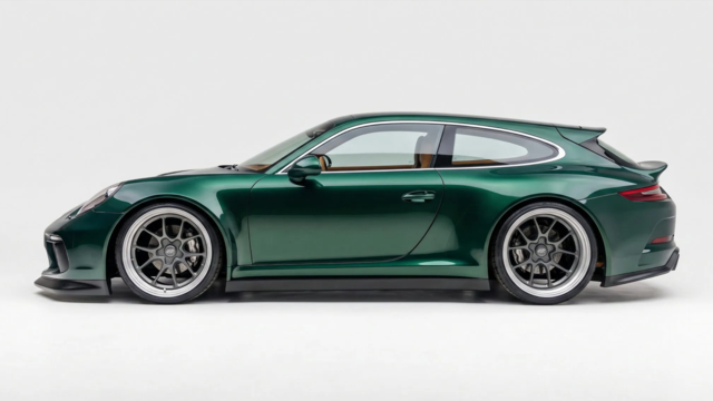
Tuner Is Converting Porsche 911s Into Shooting Brakes
Slideshow: A Polish Porsche specialist is moving ahead with one of the most unusual 911 conversions in recent memory: a shooting brake version of the 991-generation sports car.
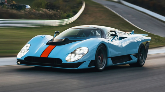
This Coachbuilt Creation Is A Modern Take on the Legendary Porsche 917
Slideshow: A Porsche Carrera GT has been transformed into a one-off coachbuilt machine that blends analog supercar engineering with styling inspired by the legendary 917 race cars.
Is This Convertible Cayenne A Steal, Or A Returnless Investment?
Slideshow: A heavily modified Porsche Cayenne convertible with faux wood trim and a long list of flaws recently sold at auction for surprisingly little money.