
OT: Just bought Suunto X9Mi GPS watch...coolness in a box
 03-31-2007, 03:39 AM
#1
Race Car
Thread Starter
Join Date: May 2005
Location: Being censored by a Moderator
Posts: 4,074
Likes: 0
Received 1 Like
on
1 Post
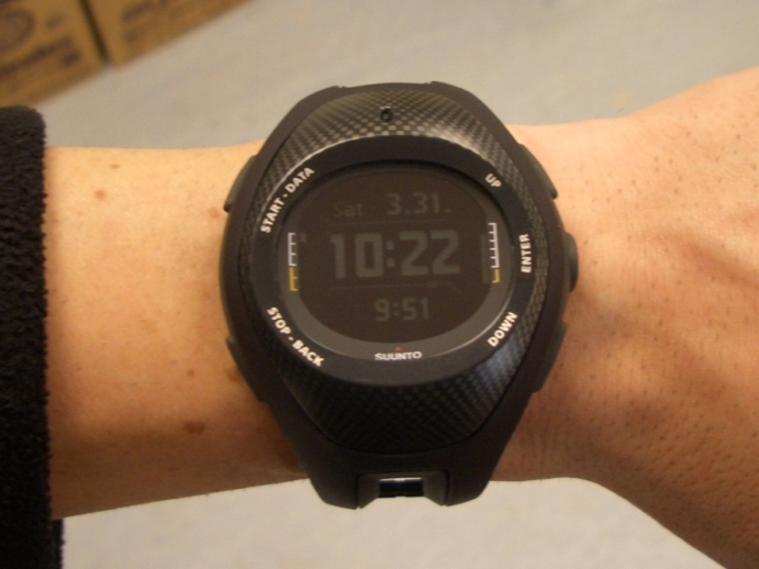
I retired the Submariner as life was too boring out here with it, plus it doesn't have an alarm  so its soley on diver duty. I just bought the new X9i mil spec watch, damn this thing is cool!!!!
BTW I just noticed the time on the bottom 9:51!!!! The main time is afghanistan the time listed below is Iraq with the daylight savings time. Its funny, Afghanistan doesn't do daylight savings.
Its a rechargeable watch, hooks up to a USB cable via 4 prongs on the back of the watch (clip like device handles the charging and it takes about 35 min for a full charge). With hardcore GPS usage (up to the second coordinate imaging etc) battery lasts for 5 hours. Normal use with frequent GPS usage is 1 month per charge.
Day Shot
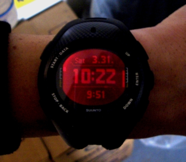
Night Shot - with light activated for use
Description:

The Suunto X9M/i ("Military") is a new version of Suunto's incredible X9iGlobal Positioning System wristop computer,designed specifically for Military professionals looking for theultimate field watch. The array of functions offered by Suunto'swatches is still there in the X9M/i, but with some added features thatmake this watch even more valuable to our friends in the Military, bothat home and abroad. The X9M/i allows you to plan routes through thefield of operations and save them into your watch, which will adviseyou as to your bearing and the right direction to take to get to yournext way point, as well as the way back. Just select the 'find home'feature and your Suunto X9M/i will guide you along the route andprovide the distance between your current position and "home".
Specifications:
Altimeter
Current altitude
Resolution 1 m / 3 ft
Vertical speed
Display range -500 m to 9000 m / -1500 ft to 29500 ft
Total ascent /descent and higest/lowest altitude, in recorded logs
Altitude alarm function
Barometer
Display range 300 to 1100 hPa / 8.90 to 32.40 inHg
Graphical display of pressure trends for last 6 hours
Stores barometric pressure data for last 7 days / 168 hours
Absolute barometric pressure at the current location
Barometric pressure at sea level
Resolution 1hPa / 0.05 inHg
Thermometer
Display range -20�C to +60�C/-5�F to +140�F
Stores temp data for last 7 days / 168 hours
Resolution 1�C / 1�F
Compass
Bearing lock mode (toward a set bearing or a GPS waypoint)
Tilt Compensated
Simultaneous bearing tracking, altitude or time display with bearing / compass rose
Bearing display in degrees and cardinal points
Resolution 1�
GPS / Navigation Mode
Resolution 1 m / 3 ft
12 channels
Integrated loop antenna
Programable alarm points
Distance from current location to final waypoint
Estimated travel time to next waypoint based on current speed
Estimated travel time to destination based on current speed
Estimated arrival time at final waypoint in route based on current speed
Altitude difference between current location and next waypoint
Total amount of ascent from the current location to the final waypoint
Current speed
Heading in degrees
Deviation from course (left/right)
Track Back function activates navigation along recordedtrack back to starting location
Memory
50 routes (each route can include up to 50 points)
500 waypoints
25 log files
25 tracks (8000 track points)
"Suunto Trek" PC Software / SuuntoSports.com
Adapter: Serial port to Suunto wristtop connection, automatic detection of connection, wristtop automatically enters transfer mode.
System Requirements: � Min CPU speed 350 Mhz � 64 MB of RAM � 30 MB available hard-disk space � Microsoft� Windows 98, Windows NT, Windows 2000, Windows XP � Minimum screen resolution: 1024 x 768
Tracks: View tracks on a map or a list of track points,edit track-related information, store
tracks in folders and upload tracks to SuuntoSports.com.
Routes: Create, edit and view routes on a map, store routes in folders and upload routes to
Suunto X9 or SuuntoSports.com.
My Points: Add, edit and view your own waypoints. You can also download these from
SuuntoSports.com.
Settings: Edit the Suunto X9 settings and clear the SuuntoX9 memory to make room for new
data.
Maps: Compatible with digital mapping services worldwide and National Geographic TOPO! in the United States.
SuuntoSports.com: upload logs, link logs with places theywererecorded, compare results, share experiences, organize virtualcompetitions.
Time
12/24 hour clock
Time/date auto-sync option via GPS
Dual time display
3 daily alarms
Stopwatch with up to 29 split times, 20 hour max
Other Features
Red Backlight for safe use at night
Water-resistant to 100m / 330ft
Size: 2.2 x 2.2 x .67 in. / 56 x 56 x 17 mm, Weight: 76g / 2.68 oz
Operating Temperature -20 �C to +60 �C/-5 �F to +140 �F
Storage Temperature -30 �C to +60 �C/-22 �F to +140 �F
Rechargeable battery (500 charges, factory replaced)
Daily sunrise / sunset times
Adjustable backlight
Adjustable display contrast
Mineral crystal glass
USB charger and PC connector
Suunto Watch Face Specs(cm)
Thickness: 1.86
Casing Diameter: 5.2
so its soley on diver duty. I just bought the new X9i mil spec watch, damn this thing is cool!!!! BTW I just noticed the time on the bottom 9:51!!!! The main time is afghanistan the time listed below is Iraq with the daylight savings time. Its funny, Afghanistan doesn't do daylight savings.
Its a rechargeable watch, hooks up to a USB cable via 4 prongs on the back of the watch (clip like device handles the charging and it takes about 35 min for a full charge). With hardcore GPS usage (up to the second coordinate imaging etc) battery lasts for 5 hours. Normal use with frequent GPS usage is 1 month per charge.
Day Shot
Night Shot - with light activated for use
Description:
The Suunto X9M/i ("Military") is a new version of Suunto's incredible X9iGlobal Positioning System wristop computer,designed specifically for Military professionals looking for theultimate field watch. The array of functions offered by Suunto'swatches is still there in the X9M/i, but with some added features thatmake this watch even more valuable to our friends in the Military, bothat home and abroad. The X9M/i allows you to plan routes through thefield of operations and save them into your watch, which will adviseyou as to your bearing and the right direction to take to get to yournext way point, as well as the way back. Just select the 'find home'feature and your Suunto X9M/i will guide you along the route andprovide the distance between your current position and "home".
Specifications:
Altimeter
Current altitude
Resolution 1 m / 3 ft
Vertical speed
Display range -500 m to 9000 m / -1500 ft to 29500 ft
Total ascent /descent and higest/lowest altitude, in recorded logs
Altitude alarm function
Barometer
Display range 300 to 1100 hPa / 8.90 to 32.40 inHg
Graphical display of pressure trends for last 6 hours
Stores barometric pressure data for last 7 days / 168 hours
Absolute barometric pressure at the current location
Barometric pressure at sea level
Resolution 1hPa / 0.05 inHg
Thermometer
Display range -20�C to +60�C/-5�F to +140�F
Stores temp data for last 7 days / 168 hours
Resolution 1�C / 1�F
Compass
Bearing lock mode (toward a set bearing or a GPS waypoint)
Tilt Compensated
Simultaneous bearing tracking, altitude or time display with bearing / compass rose
Bearing display in degrees and cardinal points
Resolution 1�
GPS / Navigation Mode
Resolution 1 m / 3 ft
12 channels
Integrated loop antenna
Programable alarm points
Distance from current location to final waypoint
Estimated travel time to next waypoint based on current speed
Estimated travel time to destination based on current speed
Estimated arrival time at final waypoint in route based on current speed
Altitude difference between current location and next waypoint
Total amount of ascent from the current location to the final waypoint
Current speed
Heading in degrees
Deviation from course (left/right)
Track Back function activates navigation along recordedtrack back to starting location
Memory
50 routes (each route can include up to 50 points)
500 waypoints
25 log files
25 tracks (8000 track points)
"Suunto Trek" PC Software / SuuntoSports.com
Adapter: Serial port to Suunto wristtop connection, automatic detection of connection, wristtop automatically enters transfer mode.
System Requirements: � Min CPU speed 350 Mhz � 64 MB of RAM � 30 MB available hard-disk space � Microsoft� Windows 98, Windows NT, Windows 2000, Windows XP � Minimum screen resolution: 1024 x 768
Tracks: View tracks on a map or a list of track points,edit track-related information, store
tracks in folders and upload tracks to SuuntoSports.com.
Routes: Create, edit and view routes on a map, store routes in folders and upload routes to
Suunto X9 or SuuntoSports.com.
My Points: Add, edit and view your own waypoints. You can also download these from
SuuntoSports.com.
Settings: Edit the Suunto X9 settings and clear the SuuntoX9 memory to make room for new
data.
Maps: Compatible with digital mapping services worldwide and National Geographic TOPO! in the United States.
SuuntoSports.com: upload logs, link logs with places theywererecorded, compare results, share experiences, organize virtualcompetitions.
Time
12/24 hour clock
Time/date auto-sync option via GPS
Dual time display
3 daily alarms
Stopwatch with up to 29 split times, 20 hour max
Other Features
Red Backlight for safe use at night
Water-resistant to 100m / 330ft
Size: 2.2 x 2.2 x .67 in. / 56 x 56 x 17 mm, Weight: 76g / 2.68 oz
Operating Temperature -20 �C to +60 �C/-5 �F to +140 �F
Storage Temperature -30 �C to +60 �C/-22 �F to +140 �F
Rechargeable battery (500 charges, factory replaced)
Daily sunrise / sunset times
Adjustable backlight
Adjustable display contrast
Mineral crystal glass
USB charger and PC connector
Suunto Watch Face Specs(cm)
Thickness: 1.86
Casing Diameter: 5.2
 03-31-2007, 04:24 AM
#2
Race Car
Thread Starter
Join Date: May 2005
Location: Being censored by a Moderator
Posts: 4,074
Likes: 0
Received 1 Like
on
1 Post
When I plug I plug it into my laptop or desktop, it shows me maps of where I've been etc. and I can map out where I want to go and then just request the waypoint and sync with a satilite and go! I can either download up to date maps of cities etc, or if all I have is an internet connection, I can download Google Earth maps of specific geographic locations and use those (even though they're older).
Best part about this watch is, if someone recovers my body in the middle of no where, they can see where I was going or where I went/came from. This works in cities as well, and the coolest thing is, if I ever get dropped off in the middle of no where, I can always set my bearings and plod along to where I am supposed to go, or find home. I CAN NEVER BE LOST....EVER!
Barometer/Altimiter
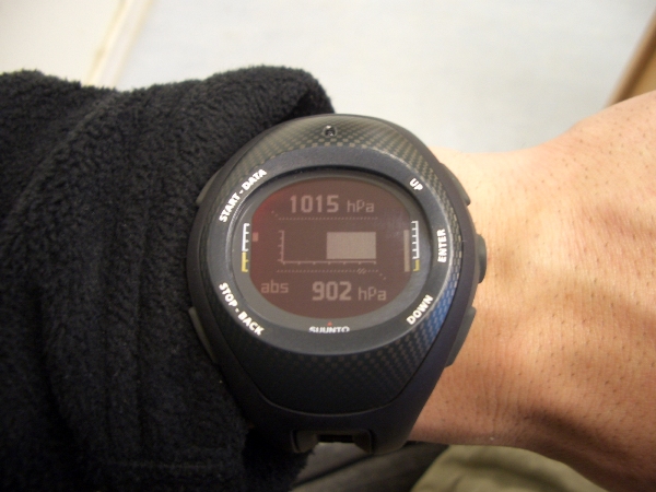
Coordinates

Screen Shot from training sample

Best part about this watch is, if someone recovers my body in the middle of no where, they can see where I was going or where I went/came from. This works in cities as well, and the coolest thing is, if I ever get dropped off in the middle of no where, I can always set my bearings and plod along to where I am supposed to go, or find home. I CAN NEVER BE LOST....EVER!
Barometer/Altimiter
Coordinates
Screen Shot from training sample

 03-31-2007, 04:54 PM
#5
Race Car
Join Date: Jun 2004
Location: State of Confusion
Posts: 3,696
Likes: 0
Received 0 Likes
on
0 Posts
Here is the feature he is going to use...
You can also head out into the field without a preset route, and use your X9M/i to keep track of your position, speed, and distance traveled
http://www.suuntowatches.com/Suunto-X9Mi.pro?sNav=3
You can also head out into the field without a preset route, and use your X9M/i to keep track of your position, speed, and distance traveled
http://www.suuntowatches.com/Suunto-X9Mi.pro?sNav=3
03-31-2007, 11:06 PM
#6
Race Car
Thread Starter
Join Date: May 2005
Location: Being censored by a Moderator
Posts: 4,074
Likes: 0
Received 1 Like
on
1 Post
^^Testa, a man after my own heart - yes this is also true  not only lateral speed but also vertical speed in the event of climbing up hill, the degree of the slope you're going up, and rate of decent. Switches between km/mph easily.
not only lateral speed but also vertical speed in the event of climbing up hill, the degree of the slope you're going up, and rate of decent. Switches between km/mph easily.
03-31-2007, 11:25 PM
#7
Addict
Lifetime Rennlist
Member
Lifetime Rennlist
Member

Sorry dude, I love the new watch. It is awesome as hell, and I know it is much more functional for where you are. But you're killing me that you gave up the Rolex. And by the way Guns, how are the shaved arms doing?
My pal!

My pal!
Trending Topics
04-01-2007, 04:19 AM
#9
Rennlist Member
Originally Posted by guns951
When I plug I plug it into my laptop or desktop, it shows me maps of where I've been etc. and I can map out where I want to go and then just request the waypoint and sync with a satilite and go! I can either download up to date maps of cities etc, or if all I have is an internet connection, I can download Google Earth maps of specific geographic locations and use those (even though they're older).
Best part about this watch is, if someone recovers my body in the middle of no where, they can see where I was going or where I went/came from. This works in cities as well, and the coolest thing is, if I ever get dropped off in the middle of no where, I can always set my bearings and plod along to where I am supposed to go, or find home. I CAN NEVER BE LOST....EVER!
Barometer/Altimiter
Coordinates
Screen Shot from training sample
 04-01-2007, 12:17 PM
#12
Addict
Lifetime Rennlist
Member
Lifetime Rennlist
Member
Originally Posted by MPD47
Not gonna lie, that's one of the coolest watches I've seen.
 04-01-2007, 02:10 PM
#13
With Nokia Suunto is another high tech manufacturer here in Finland. Suunto is quite old company ; they have made for example compasses from the '20's. I have my grand fathers old Suunto compass he purhased in 1928. He also had it in winter war back in 1939 when we fought against Russians. This compass still performs great.