When you click on links to various merchants on this site and make a purchase, this can result in this site earning a commission. Affiliate programs and affiliations include, but are not limited to, the eBay Partner Network.
After we grabbed that third point as an out and back it was time to head for the ocean. We found a bunch of the adventure tour vehicles there where the pavement reached the ocean.
The route went along the coast and some way points looked like they were on the beach so we didn't stop to check out the little fishing village and just headed south on the little tracks down the rocky shoreline.
The cliffside moved back from the ocean and we could see that the waypoint was on the beach a few Km ahead. The beach didn't look drivable so we continued on the track hoping for a better place to access it.
As we got closer to the waypoint we saw the Jeep and the Raptor again and they were stopped between the track and the rocky dune right near the waypoint, then we realized why they were stopped and approached very carefully.
They already had the Jeep hooked up to the Raptor to try to pull it our and were working on digging placements for traction ladders. They agreed that there wasn't much more we could do to help them with the extraction so we walked over to scout the waypoint,
Not the driveable beach we had hoped for and no good access in sight.
When we walked back to the Cayenne and the extrication efforts they were still stuck they had given up on using the Jeep and were hooked up to another Raptor for an more even weight match. That hadn't worked either and they were discussing the next thing to try. We mentioned that we had seen the big green Unimog at the road head earlier and as we were offering to drive back in the hope they were still there we saw a dust cloud approaching in the distance.
The cavalry arrived shod with massive tractor tires. Then one of the Blazers came at the waypoint from behind the dune. He came in pretty fast so once he started to sink into the mud he did the only logical thing which is stay on the throttle and try to drive out. It didn't work.
You can see him in the distance behind the standing water. That blazer would end up being our match for points and pace later in the race, we'll see a lot more of him.
Here is a video posted by the couple in the jeep of the extraction. This video and the following two pictures were posted by other participants to the public facebook group from the event. If it's your photo or video and you would like linked credit or if you don't want it cross posted here please let me know.
We had found a likely viable route out the the rocks so we gave it a try. We made it over to the rocks while the extrication was still in process.
I backed it up the loose rock dune for two reasons. We had decided early on that we wouldn't drive into anything we weren't fairly confident we could drive out of and to get the GPS receiver from the data logger which was on the roof behind the rack closer to the actual waypoint.
That X on the beach is the point we needed to get within 25 meters of. my our GPS's we were at 17 meters.
The Jeep also made it over to the rocks with us and got the waypoint as well and then drove down the rocks further and winched the Blazer out. We would later learn we were the only two teams to get those points.'
As we were crossing back to the track we found the other Raptor stuck near where we crossed. It made us a bit nervous. If you look closely you'll notice this isn't the Raptor with the bed mounted spares and it's buried just at the rear axle. You'll also notice we had already crossed when this photo was taken. The Mog was already lining up for the extraction and the crown vics had arrived so we quickly got on our way before we saw anyone else get stuck.
We had a lot of distance to make down the coast to the next waypoint
It was already after 10 am and we were barely into a HUGE day mileage wise and the dunes were still ahead of us.
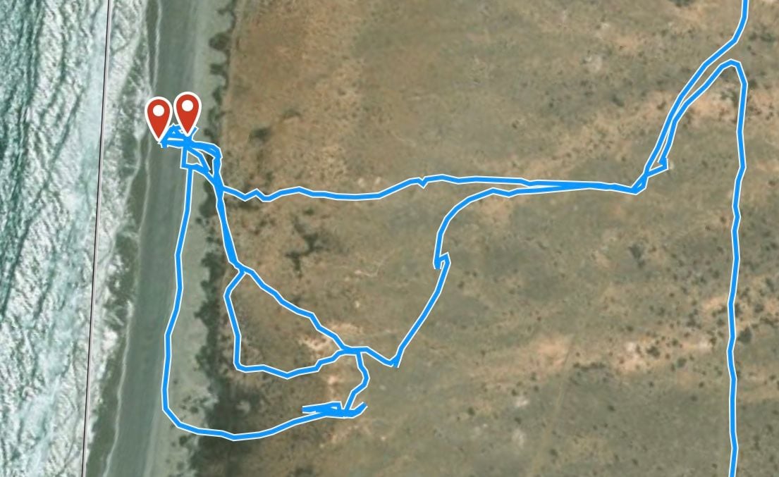
For the most part, our nav track showed the path of the car and it was easy to see that we had come close enough to the waypoint. Mostly the WPs were in a roadway and it was pretty much impossible to not come within 25m of something that's in the middle of a 4m road. Even when the WP was in open space, like on a wide beach, we could easily see that we got the WP. But in cases where maneuvering was really difficult, like on this stone dune or on a sand dune, we didn't have the luxury of driving straight to and over it. What you see on all of these images is actually the track of the iPad: we would get out of the truck and find the exact WP, then figure out how to get the right rear window of the Cayenne within 25m of it because that's where the GPS logger was and ITS track (which we couldn't see) is all the race organizers cared about.
This is the track for the first one. The other trucks were stuck pretty much right in the middle of the pic and the WP (the outer mark) was right where the small waves were breaking. I took the iPad down to the beach and marked the spot, which was about 16m from the top of the dune. I'm not sure if it was even in the car during much of this other than arriving and leaving. The path the car took was amongst the lower tracks, south of the soft spot that the trucks were in. The second WP in the pic is one we dropped to mark where the GPS logger was on our final attempt, so we could verify the distance. Later we found easier ways to do that.
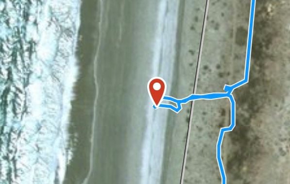
Similar approach on the following beach WP, but this time we knew what we were doing. Walk to the WP, get the Cayenne there, get back in and drive away.
I don't think Cam's post really shows how hard it was to drive on that dune. It's all round, smooth, uniformly sized stones which would just spread and push around when a tire goes over. Add the incline, and there was not much traction. Cameron took a number of fast running starts (we should have video of it somewhere) to get the back window as high as he could, but "plowing a short furrow" is a much more accurate description than "driving." Even the Jeep, much lighter and with fatter tires, had a pretty hard time.
After the last beach way-point on the pacific coast we had about 40 minutes of rough rocky seldom traveled track back to the 1 where we would head south to the dunes just north of Guerro Negro and the border to Baja Sur. If you scroll back up to the days race sheet you'll see there were 7 "cross in order" waypoints out in the dunes looking at them on the map we worried about possibly catching one out of order as some of them seemed fairly close together. We got there and saw the couple who got skunked out of a jeep rental and were in a Honda CRV. They had gone into the edge of the dunes to check it out and come back out. While we were talking to them, airing ourselves down and airing them up from our on-board air hookup we saw the lone 4 wheeler participant coming back out. His were the tire track you could see on the ocean side of the rock dunes in the photos above. We should have known something was up at that point. If you caught all the waypoints you wouldn't come back out the same way. Having left the bog ahead of most of the field we felt good about trying our luck in the dunes as there would be people coming behind us if we needed a tow. We ran a go-pro on the roof in the dunes so tomorrows goal is to chop that into something vaguely watchable. In the mean time here are a few photos.
I also found one of backing up the rock dune. The quality got trashed when I rotated the video. I'll keep playing with it and re-upload it if I can get it to work better. I have lots to learn on how to edit and convert video for optimal youtube posting and rennlist doesn't seem to support embedding videos posted on smugmug.
As we came into the dunes things went fairly smoothly. There was enough plant life that the tracks were pretty set and as long as you chose where to stop with some care it was easy to not get stuck. As we got further out into the main dune field the plant life thinned and it open into the rolling lines of dunes you can see on google maps satellite view: https://www.google.com/maps/@28.0563.../data=!3m1!1e3
We came in from north east corner of the dune field and the track had us heading roughly south west. We hit the first way-point easily as it was in one of the firm dark areas between the dunes that you can see in the imagery above. The next point had us crossing one "line" of dune and after a brief scout on foot to find the exact spot so we were able to approach it in a fairly strait line and wouldn't have to circle in soft. The next point was about a Km away and while we needed to head mostly in a line down the troughs to get to it we would have to crisscross some ridges too. This proved very difficult as the sand was very hot, dry and soft on the ridges in the midday sun. This picture posted by another participant to the facebook group shows the drastic difference between the darker troughs and the ridges. It got very soft very quickly.
After about an hour of trying to find a way and making very slow progress we decided that it would take us all day to finish the dunes section and there were still hundreds more kilometers to go. The temp gauge was also starting to climb for the first time on the trip. Once we decided to head back out the way we came we realized we had broken one of our rules: don't drive into something you can't drive back out of. That little dune decent posted in a video above would be a very difficult or impossible to try to climb back up as the run up to it was soft and not strait. We found an alternate way around that little drop and headed back out the way we came in. As we reached the tarmac at about 2pm there was a group of other participants airing down.
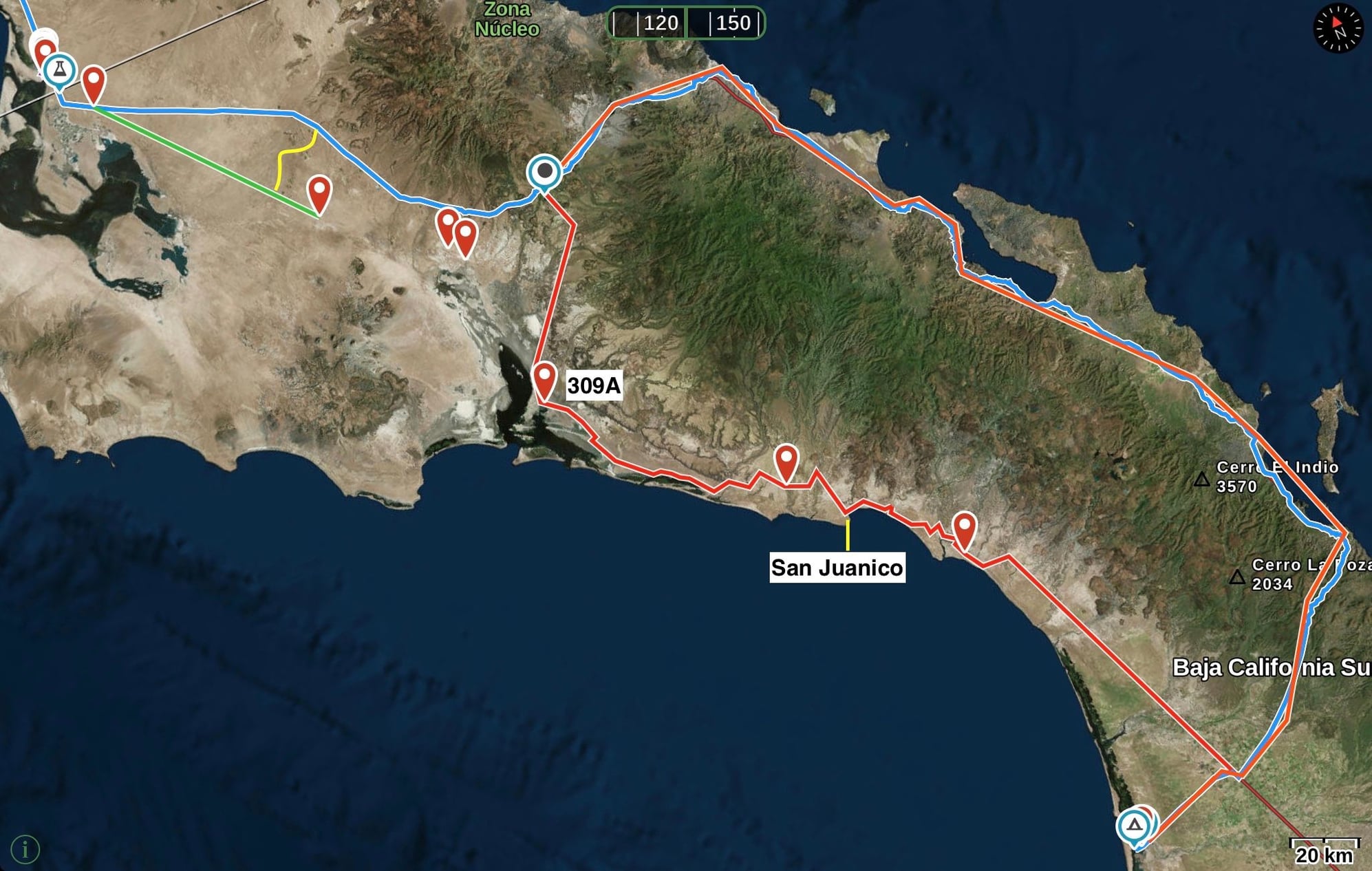
From that point we had about 80 km of tarmac to a decision point. We could head down the pacific coast predominantly off tarmac or stay on the 1 for a much longer route but tarmac the whole way. We ran projections on travel time and the remaining points. There would be no way we would make the finish within the day's 14 hour time control if we took the off road route. 306 was a shortest route challenge 10 points if you have the shortest route but going down from there with everyone but the top 5 shortest getting 5 points. So taking the conservative assumption of only scoring 5 points for 306 that meant there were 17 points to be had taking the off-road route and a very long night. Finishing in under 14 hours was worth 15 points. We had also been told at the morning race briefing that teams arriving after 9 or 10 pm would likely be locked out of the camp ground area and would need to find other arrangements. Timing to finish the day in under 14 hours was tight on the road but if we make quick work of the necessary fuel stop and didn't have unforeseen delays we projected getting in with about 15 min to spare. If you want to check it out on a map we were near Guerro Negro and the bivouac was in Adolfo Lopez Mateos almost 600 km a to travel.
Several hours of it would be in the dark and we would have to cross the mountains twice as we traveled from the Pacific across the peninsula to the gulf of California and back to the Pacific again. There would also be a number of towns to pass through that would drop our average speed as well. The final factor considered was that we were all already tired from the day and there was little possibility for passengers to rest if we are off-road and chasing way-points.
We opted for the tarmac route and gunned it South. The mountains were much greener down here:
We were pretty close to our projected pace as we came into Santa Rosalia, a little industrial port town which would be our fuel stop
We caught up to the spirit class Martinelli Volvo
And then ripped through a beautiful little oasis town at sunset
We hadn't been able to add any time to our projected 15 min buffer on finishing in under 14 hours and with night coming the pace would be hard to maintain.
As the night settled in we were still in the mountains and the truck and slow traffic hadn't let up yet as it was still early. On a the previous trip Jake and I were on (the Curva Pelligrosa = Don't Lift trip) we had learned that with effective spotting from the co-drivers passes could be made in the mountains in seemingly reckless and aggressive places with a reasonable margin of safety.
By watching the gps for topography and turns in concert with watching the road one or more turns ahead for headlights you can dive into a pass in otherwise blind location knowing what is coming when. We made countless passes like this trying to keep on pace for the 14 hour day. We managing to maintain our 15 minute buffer. One of the passes just as dusk was past a group of three cars, we didn't realize until we were well committed that the front car was an entrant, we hoped we hadn't just surprised or annoyed them enough to garner a complaint for fast or aggressive driving that would draw scrutiny to our speed logs as we had been in excess of 120 km/hr a fair bit on the tarmac in an effort to maintain our timeline.
Then as we were coming out of a little town on the coast just before crossing back west towards the pacific we came upon a motorcycle entrant stopped on the shoulder. He was in a pretty poor spot to be stopped from a safety stand point so it was clear he hadn't stopped for a planned rest. We turned around as soon as we could and went back to check on him. He had a flat tire. He had a spare tube and some but not all of the tools he needed. He also had no idea how to change the tube. Anton owns a BMW motorcycle repair shop and I worked for him for a number of years as a side job for enjoyment on my days off as an RN. Needless to say we can fix a flat on a motorcycle.
Normally both of us would have liked to take the time to teach the rider how to do it himself the next time but we were on a very tight timeline.
He was super grateful for the help, he had been thinking he would have to spend the night there on the side of the road and then try to figure out a repair in the daylight. We were there 34 min. Considering our tools were under all our luggage and supplies in the spare wheel well and we were working on a totally unfamiliar motorcycle in the dark we made very quick work of the repair. But would it be quick enough. Our 15 minute buffer was gone and now we not only had to maintain our projected pace we needed to find 19 minutes to recover in the dark. To make matters slightly worse the entrant we had passed in the three car blind inside corner pass came past us as we were repairing the flat. We would have to pass them again.
Once we cleared the mountains our ever evolving math showed that we need to average 115 km/hr to make it in exactly 14 hours. We were done with the mountains so speeds would be higher but there were two big towns which would have at least stop signs and speed bumps if not a traffic light as well as numerous small villages to pass through. In the coming hour and a half we would spend a fair bit of time at 140 km/hr we decided to take the gamble on further exceeding the 120 km/hr limit from the tracking sheet in the hopes it would't get checked and we could still get the 15 points for finishing time.
As we started to get closer our fuel range started to come into question, we had burned a full tank in a bit over 300 km. With a 26 gal tank the cayenne typically has a range of over 300 miles to a tank even fully loaded and driven aggressively and over 500 miles when driven gently. We had 5 more gallons in the can on the rear of the truck but we didn't have the time to put it in. We managed to get into camp on fumes without stopping. Here is the race sheet we turned in.
We missed it by 13 minutes. Stopping was the right thing to do and none of us regretted or questioned that choice. It would have been a miserable, cold, loud and dangerous night on the shoulder of the 1 for that rider. The rules for assisting other participants are as follows, not stopping to check on and assist others to the best of your ability is grounds for disqualification from the event. If you are helping with an extrication or a mechanical issue you get "karma points" for your efforts. If there is an injury and you are providing medical care you will be awarded full points for the day.
Looking at it with clarity of hindsight, taking the 1 was a strategic mistake that we might not have made had this happened later in the rally when we were better at this. We estimated it was 400 km from the split to bivouac on the 1 (paved all the way) and 350 via the race route (a bit over half paved and the rest something else; the satellite maps weren't clear). But the 1 was actually about 420km and slower than we'd anticipated due to the mountains, and on the race route the paved part was the second half, which we would have driven at night, and where the roads were very straight across the coastal plain. It really is a perfectly straight road for the last 100km, as the line shows. The Unimog and the earth cruisers, which were behind us when we left the dunes, pulled into camp not long after we did having surely traveled the race route. We would have gotten in later, but we could have gotten 17~20 points rather than nothing. And that is a lot of points when we only finished 90 points off the podium and 100 points out of 1st.
However, that's the decision we made based on what we knew and how we were feeling at that time. And although it would have been harder to pull off than we anticipated, the 1 (and 15 finishing points) was achievable without the repair stop. And the repair stop, of course, made all the difference in the world to rider 131 and earned us valuable Karma Points which we would redeem immediately at bivouac.
Here's what the second part of the day looked like. The dunes are in the upper left, the burette is the hilarious decontamination station at the BCN/BCS border, and Puerto Lopez Mateos is the lower right. 306 (the SHORT) is the green line, and the yellow is a paved road that we could have used to get 306B. That yellow line was really the ultimate decision point because going down it meant giving up the finishing bonus 6~7 hours later and committing ourselves to whatever the offroad sections brought us. The race route was paved most of the way from the split to 309A and again from San Juanico to the end.
The repair was roughly at the bottom of the bay that is halfway through the upper route that we took instead.
This was a very long day. From the time we left the dunes in the afternoon, we were on the 1 for 575km, 350+ miles.

 02-18-2019, 11:27 AM