When you click on links to various merchants on this site and make a purchase, this can result in this site earning a commission. Affiliate programs and affiliations include, but are not limited to, the eBay Partner Network.
I left day two with us climbing up and over the central mountains from Mike's sky ranch. As we came down the other side we dropped into a lush little valley and the backside of a ranch.
That sign for twist turns was one of the first we would see of a very entertaining phenomenon; in Baja you can drive for hours out into the middle of nothing and then suddenly come upon a street sign that looks as if you were in a city.
The sign was right, it got steep, twisty and rough.
When we reached the ranch the gates were all open and the road passed about 5 meters from the main house. This is as good a place as any to explain standard Baja road and property etiquette. If it looks like the road goes through someone's yard it probably does, simply drive politely and head on through. If you come to a closed gate on a road near a house or not simply stop, open it, drive through, close it behind you and carry on with a bit of an extra wary eye out for cows. If you come to a locked gate or a sign that says "Propiedad Privada" then you are no longer on a "road"
This particular ranch was in fact bisected by the public road, we say no signs of people around when we passed through but the ranch was well kept. We would hear days later that some of the cars that left later in the morning found the property owner had decided he'd seen enough traffic for the day and had closed and locked his gate. They had to back track all the way back to Mikes and drive around adding hours to their day.
As I mentioned previously this was a day that was briefed too long to get all the points within the time allotment. We spent a lot of time weighing the various route permutations for the day and decieded to exclude 205 which was worth 26 points but at our rate of travel from the morning would have taken us 8 or more additional hours to complete. We were also concerned about balancing the abuse on the truck to ensure we could make it to the finish 8 days later. We wanted to be sure to get the 20 points for finishing the day in under 14 hours but we still had a bit of time to play with so we headed up the first part of the 205 segment to get 206 and importantly 207 which was a "Save"
206:
207:
The route we found to get up to those two was pretty rough so we decided to take an alternate route down which turned out to be awesome.
It was also a chance to open it up a bit in the dirt.
Here are a few views of how the nav could go during the day. As time went on we learned a lot more about what we needed to do as soon as we got the day's waypoints, but even on day 2 we were learning about the strategy.
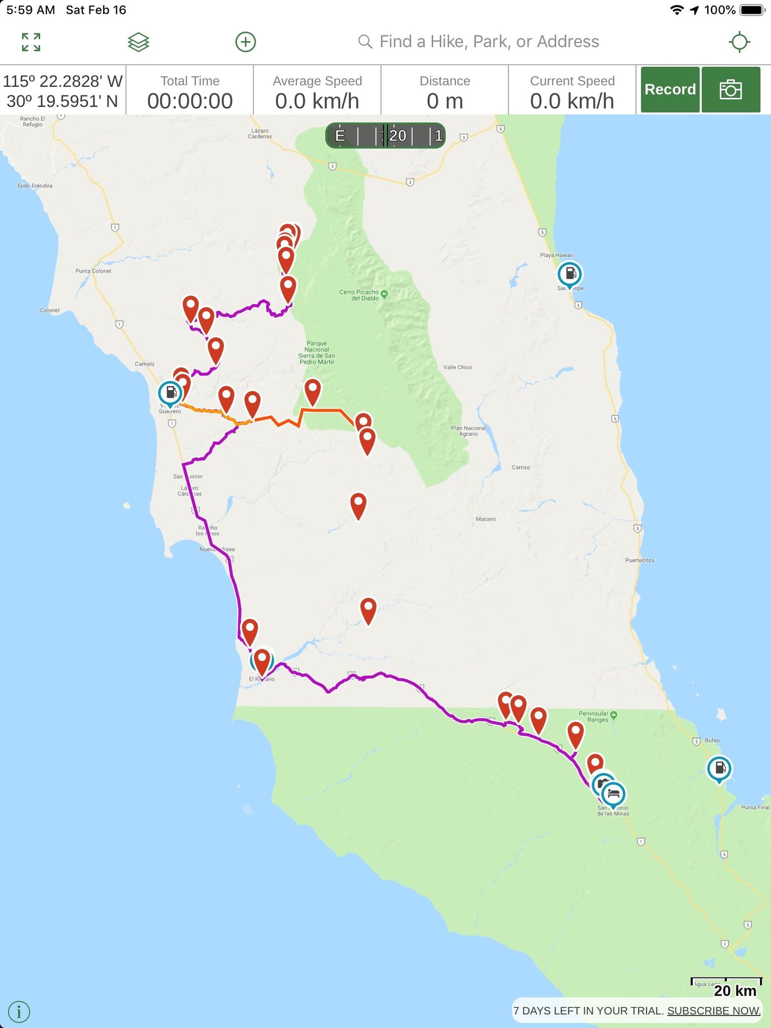
The first is an overview of Day 2, using the Google Maps imagery in Gaia (the app that we used for most of the nav). There are two macro-choices: backtrack to the north and hit the paved roads (3 east, 5 south, 1 north) to the Catavi�a bivouac, or follow the unpaved roads to the south where the points lie. Based on where the escape points on the race route are, the northern section of the unpaved roads forms three sections containing waypoints: the first (with the first five or so WPs) is not optional because it's the only road out of Mike's, but the second two could be skipped if needed. People who wanted an easier day could backtrack to the paved road, and people who wanted more adventure could go south and then have the option of going straight west to the coastal road if they found it was more than they wanted to continue doing. Even if someone skipped the 2nd and 3rd sections, they would still be able to get the last five waypoints (the 208 series) which were just off the pavement before camp at the bottom of the map.
Day's route, overview
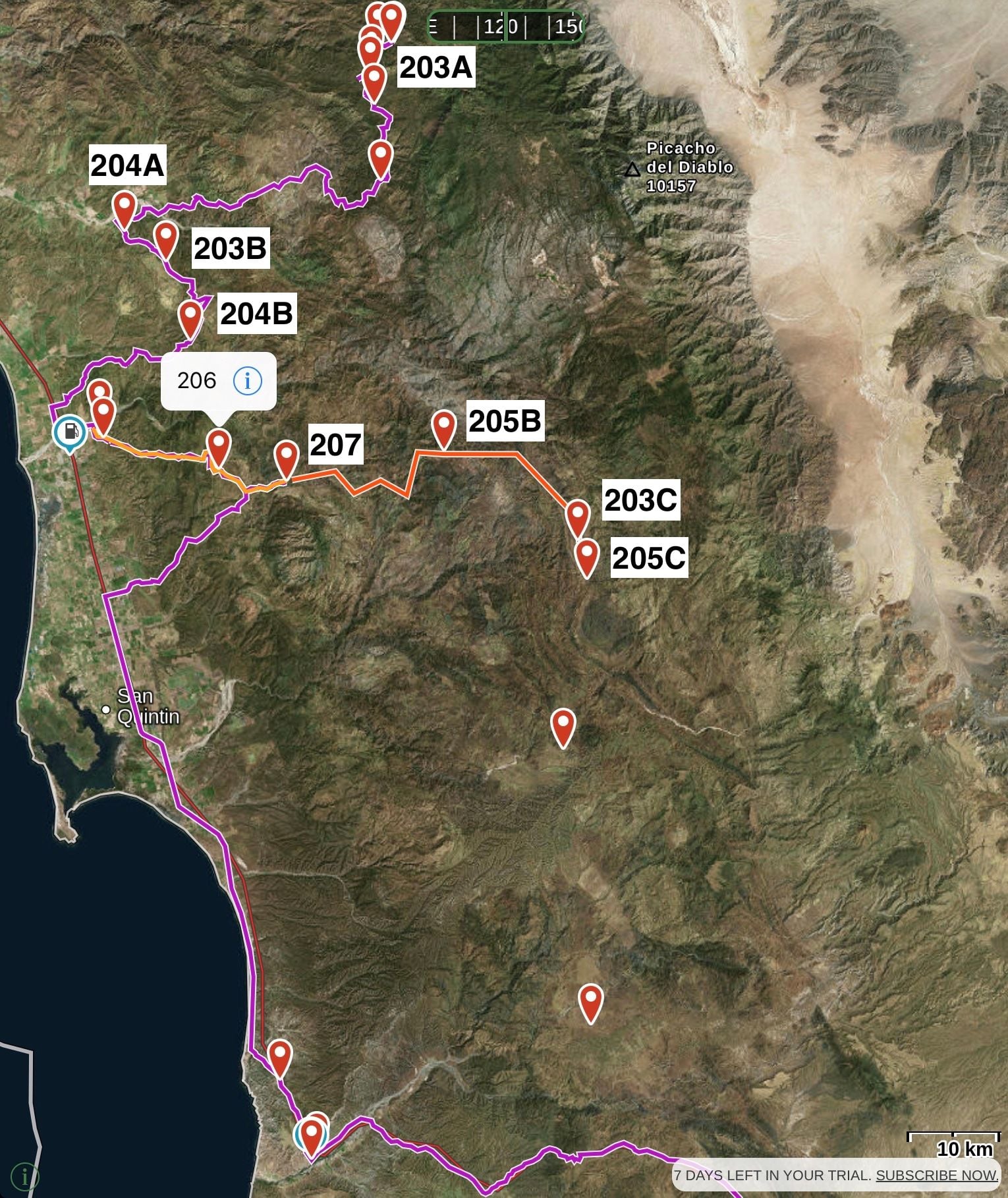
We were generally in satellite view rather than street view since we needed to know what was actually there (not what was theoretically there). The imagery we had in Gaia was a few years old, though, and we cross-checked it at times against a different image set on a laptop and against the street map that was on the Garmin map we bought from the organizers. Zooming in a bit on the choices, you can see that in order to get the points for the 203 series you have to complete the entire course (2nd and 3rd sections) since 203B is in the 2nd and 203C is in the 3rd. But, you can skip the 3rd and still get 204. And you could skip the 2nd and still get 205 by completing the 3rd (the unlabeled WPs on it are 205D and 205E). The purple line shows our actual track; we did the first section to 204A, the 2nd which took us back to the paved road at Vincente Guerrero, and then took the 3rd as far as 207 (the XL painted on the canyon wall) and backtracked out to the pavement again. The shortcut back to the pavement was the beautiful mesa view and fast driving that Cam shows in the previous post. By not completing that part we obviously gave up 203 and 205. Decision-making
The decision-making (what we attempted, what we skipped, where we would turn around) was an all-hands affair based on how much progress we had made at certain critical points compared to what we had projected at the beginning of the day, and how the terrain looked going forward. For instance, if we didn't think we would complete loop 3, there was no sense going any farther than 207 because there were no points to be gained short of completion. Part of the process was creating scenarios (like the orange line above) that could give us an idea about the distances and (combined with the imagery and past performance) the speed we'd be able to maintain. We wanted to finish before the time cut-off on this day, so we skipped the rest of loop 3. That caused us to lose 42 points (16 for 203 and 26 for 205) but we got 20 for finishing on time and saved a lot of wear and tear. It was only the second competition day out of nine; we needed to save ourselves for the unknowns ahead.
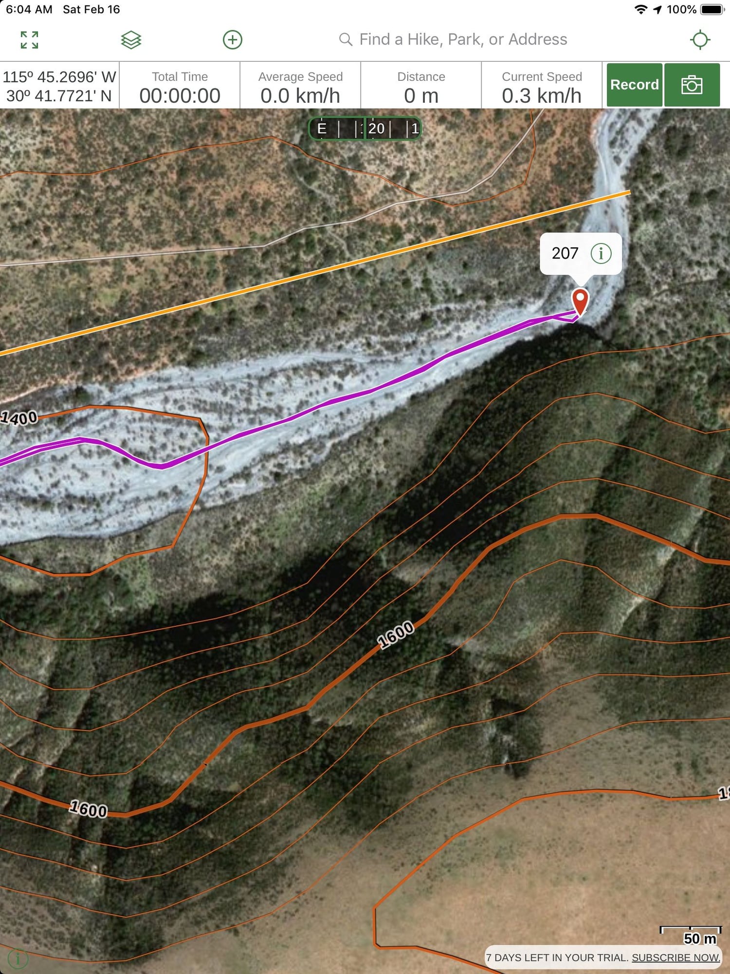
Below is a more typical view that we'd look at when we were just driving rather than planning. We could alert the driver to upcoming terrain changes, suggest one track over another, and as we approached the waypoint we could establish that we were within the required distance of it (usually 25m). To get to 207 we took some tracks like the gray line, then turned and dropped into the wash (dry riverbed) for the last few hundred meters to get to the WP. Tapping the (i) on the WP label would bring up a box which tells us the distance to it, and we typically got within two or three meters just to be safe. Some teams lost points when they went to the right place but the tracker didn't show they were close enough.
<nav_geek>The organizers listed the lat/long on the race sheet in DD MM.mmm format, and also made available a daily GPX file which could be imported into our devices in which the format was natively DD.dddddd. The GPX file displays in the device's chosen format, which for us rounded to DD MM.mmmm (four places) and we observed a few rounding irregularities compared to the sheet. At the briefing on Day 2 one driver claimed there was a discrepancy between the printed sheet and the GPX file, but I reviewed them and only found a 3rd-decimal rounding error. 0.001' is about two meters, so it was pretty unlikely to cause a problem in most cases. On Day 3, though, there were cases where we were looking for every meter...</nav_geek>
Zoomed in
*
Last edited by AntonLargiader; 02-16-2019 at 09:40 AM.
Day two wrapped up with a bunch of tarmac miles. If you look at the maps Anton posted you'll see that 207 which was where we crossed those big open mesas was still in the first third of the day and we were driving into the late afternoon sun. Once we hit tarmac we grabbed some gas.
On a couple trips to Baja I have found that both the Military and the Police who are doing vehicle stops and inspections are super into offroad racing almost to a man. Way more often then not the second question, after where are you going, is are you racing? Then either "Go, win, Go!" or a few more question's about is it fast etc. With the exception of the US - Mexico border we never had to pull out our passports or drivers licenses despite passing at least one check point a day.
We had a long tarmac run to the last few waypoints of the day. At the drivers briefing the night before the start they asked that everyone drive safely, slowly though towns and said that they would not enforce the days max speed unless there were complaints from other participants about reckless driving. So when we were passed by a local in a minivan doing over 90 mph we decided it was worth the risk to make up some time. In the open desert with the passenger focusing on watching the road 4 or 5 seconds ahead for cows you can make time pretty quickly and smoothly although a cayenne with 4 guys, a bunch of weight in gear, tools and parts, a massive roof rack and 32 inch BFG KO2 all terrains will positively guzzle fuel around triple digit speeds. The engineers had apparently anticipated our use:
We drove through another beautiful desert sunset and found the last few points in the dark.
a bit further down the road we pulled into the camp for the night to hand in our race sheet and complete the data logger upload.
We were all pretty tired after the second very full day of racing so we decided to head a couple miles down the road to town for a big restaurant meal and a cold beer. The only restaurant open was at the only hotel in town and our will gave out further at that point and we opted for a hot shower and a fresh bed even through it would mean a 4:30 wake up to get back up the road and into the desert to the briefing all packed up and ready to race day three.
Day three started before dawn, we woke to find quite a few participant cars in the hotel parking lot.
We headed back up the road to a morning briefing around a campfire and everyone busy downloading the waypoint files to tablets, laptops or phones. No scoring was posted yet.
At the briefing they said scoring for the first two days would be posted that night. We were anxious to see what was happening. We felt like there was already a lot of attrition when we looked around the briefing at, what felt like, a much smaller group. We also wanted to see how other teams had scored on day two with the various options for which points to go after and which to cut out.
Day three was also planned to be a very long day with some lighter days planned in the middle of the race for rest and repairs for those that got there. They also included some tips on driving in the dunes and on the beach as both were a part of the day's route. Just after we got on the road we passed a sign I had been waiting for since we crossed into Baja.
I had been waiting for that because the last time one of the other guys and I came down we were pit crew for a trophy truck and had made the run from Ensenada to La Paz strait through in 17 hours catching pits along the way. On that trip we decided on an alternate translation for "Curva Pelligrosa" and had it written on race tap on the dash of our rental car. Out came the race tape and the other two guys were brought up to speed on the proper translation of that particular sign.
So if you go to Baja just remember: Curva Pelligrosa = Don't Lift
Cameron - great to meet you and thank you for stopping by Cars and Coffee Folsom yesterday - loved hearing your story and seeing the pics. Please come by again as everyone thought your trip and Porsche was awesome.
Exceptionally cool. You have to submit this to Panorama.
Our chapter used to run a combined event with the local Jeep club (until PCA got super bitchy about insurance) and it was nothing short of amazing what a stock Cayenne on all season radial could do.
Exceptionally cool. You have to submit this to Panorama.
Our chapter used to run a combined event with the local Jeep club (until PCA got super bitchy about insurance) and it was nothing short of amazing what a stock Cayenne on all season radial could do.
That is definitely something I've been thinking about. I was going to shoot them an email once I have completed this thread so they would be able to see the whole story.
We tried to do as much of the navigation as possible while underway so that we could maximize efficiency . The time control for the day didn't start until you crossed the starting coordinates but this was a trick we wouldn't utilize until later in the race.
This was the second time they had a task placed out of order on the race sheet and the first of many photo upload points, it's where the middle school mantra of "Read ALL of the instructions first" comes into play. On day one we had noticed the out of order challenge that had to be completed in the timed A to B segment and almost missed it because we were so focused on making the speed we needed to complete the segment in the allotted time. We learned that lesson well on day one and didn't have any more near misses.
The first task of the day was the first average speed challenge. Points were decreased per 0.5 of a km/hr you were off the target. It was on the 1 which is the main highway down the peninsula and mostly tarmac but roads in Baja are unpredictable enough, the 1 included, that we decided it was a significant risk to just peg the cruise control at 94 km/hr. If we hit an unpaved diversion close to the end of the segment we wouldn't have time to rebuild our average speed. Looking at the satellite imagery we didn't see any diversions but the images were a couple years old and we did see the route passing through the foot hills and there are some corners down that would be pretty reckless to take at 94 km/hr. The moment we crossed the starting point we reset the trip data in the GPS which gave us average speed to the 1/10th of a km/hr and we cranked it to 115 to bank some "momentum" into our average speed. We blew past another competitor in a jeep early in the section who had clearly set cruise at 94. As we got a few km from the end we came into the foot hills and sure enough we couldn't comfortably maintain 94. It was a pretty long segment so we barely saw our average drop and we exited the hills with the finish point about 1.5 km ahead on a strait and fully paved stretch of road. We pulled over and stopped. It took about 90 seconds for our average speed to trickle back down to 94 with all the "momentum" we had banked. Once it got close we pulled away calmly and crossed the finish point at 94.1 km/hr. We never saw the jeep again that day. The crossed the start before us so should passed us while we were stopped if they were going to finish on the mark for 94. This tactic would come into play again several times and really pay off in some off-road average speed segments.
The next set of cross in this order points was out in a huge cow grazing area that was a maze of disused tracks and washes. It was also a test of the "gate rules" in Baja.
This was another point where having he satellite imagery was a huge help. The pull off point that showed a logical road to the first point was fully fenced with no gate. We found a Jeep and a Raptor parked there trying to figure out what to do. The guys on nav duty for us at the time (we all rotated tasks regularly) had already suspected this from the imagery and we didn't even come to a full stop as we turned around to head back to the gate pictured above. As suspected the route out of the valley off road to the third way-point about 15 km away as the crow flies was very hard to find. That third point was only 3 km from a paved road that was the access to the continuation of the day so we bailed back to the tarmac and circled around to come at the third point from the "wrong" direction. We found the "road" to it easily and saw the Raptor and Jeep headed out as we were about a km from the point. This validated our route choice as we were not nearly as fast offroad as the Raptor as our typical 6/10th's pace.


 02-15-2019, 10:35 AM