
OT: Drove the 3200 mi AL, MS, FL adventure & saw TONS of Porsches this time :o)
 12-06-2010, 11:25 PM
#1
Rennlist Member
Thread Starter
http://picasaweb.google.com/stever50...HighPointTrip#
Some pics are in this above link:
The last 3 trips I've taken as part of my current quest to do all the state high points left me traveling for days on end, sometimes 10-13 hours a day, and I didn't see one Porsche. Granted, they weren't in the most populated areas but still, not one in a week? I took the BMW instead of the Porsche and was glad I did. I got to take my 2 little (11 and 13) nieces to school one day and they LOVED the leather and the back seat space. I've never had my own car when visiting so it was fun to be able to do this in my own car.
They asked my why I didn't drive my Porsche down. I thought it was obvious, as the BMW was more luxurious, has XM radio and I could take them around town for the 4 days I was there. It made me think, though. Maybe next year I'll drive the 911 down if I still have it as it WOULD make for quite the adventure and handles so great, even on the straightaway of I-95.
This time, my trip had me leaving DC at 4pm on the Friday before Thanksgiving, driving about 8 hours to Knoxville, TN. and got a hotel late that night. I traveled about 6 hours the next day till I made it to Misssissippi's high point near Iuka MS. at it's whopping 806 ft above sea level. Still, it was a beautiful "hike", 1 mile each way and the trip was very memorable. Didn't see 1 Porsche on the way down all the way to Mississippi.
I left that high point and traveled the 5 hours or so to Oxford, AL, about 20 miles from AL's high point and got a hotel that night. The next morning I woke up very early and met a friend from my bimmerforum at the high point which we did together. He drove in from Atlanta to meet me there, about 1 hr 45 minutes away. No one from this forum responded about meeting to do any of these high points together when I posted here last month so I was glad to at least meet one motorhead at the high spot. We ate breakfast at the base of the the mountain at the restaurant in Mt Cheaha Park and walked the 5 minute walk to the top together. It was about 2400 ft high with a very impressive view. Still, hadn't seen 1 Porsche on the trip yet...
I left him there and drove straight to Florida's high point from there. 345 ft high - the lowest state high point with Delaware being the 2nd lowest at 435 ft, 2 miles south of the Alabama border. It was spectacularly beautiful in it's own, flat way. Once I drove to first St. Augustine Fl for the day to check that out for a day (the Lightner Museum blew me away) and then on to Miami, I saw dozens and dozens of Porsches, as was to be expected.
South Beach was loaded with them. Bentley's, Porsches, Lambo's everywhere. It was fun to be on a high point trip and finally see lots of Porsches for the eye candy that it is. I'm sorry I didn't get to hook up with the gent from this board that said to call him if I make it to the Miami area but once I met my family down there, every minute of my time was taken by my 2 little nieces and the rest of the family that was down there.
My next 2400 mi trip will be next summer, probably next August 8th week for a 9 day period to bang out 6 more state high points. I plan to fly to Denver, drive the 9.5 hours to North Dakota's high point, then do S.Dakota, Nebraska, Kansas, Oklahoma, ending with New Mexico's Wheeler Peak, which is in a different category than all the others. 13k ft compared to SD's 7k ft peak.
I'll then have to drive back to Denver to drop the car off and fly back home.
Maybe I'll post more about this when I get closer to next summer to see if anyone in one of those states wants to meet to do the high point and catch a bite to eat and talk 993's for an hour or so. I'm now at 35 state high points and counting. I hope to be at 41 by the middle of next August after the above trip is complete.
Have a great holiday,
Steve R
PS - The complete list:
Rank State Peak Elev-Ft Range
1. Alaska Mount McKinley 20,320 Alaska Range
2. California Mount Whitney 14,495 Sierra Nevada
3. Colorado Mount Elbert 14,433 Southern Rocky Mountains
4. Washington Mount Rainier 14,411 Cascade Range
5. Wyoming Gannett Peak 13,804 Greater Yellowstone Rockies
6. Hawaii Mauna Kea 13,796 Hawaii
7. Utah Kings Peak 13,528 Western Rocky Mountains
8. New Mexico Wheeler Peak 13,161 Southern Rocky Mountains
9. Nevada Boundary Peak 13,140 Great Basin Ranges
10. Montana Granite Peak 12,799 Greater Yellowstone Rockies
11. Idaho Borah Peak 12,662 Idaho-Bitterroot Rocky Mountains
12. Arizona Humphreys Peak 12,633 Colorado Plateau
13. Oregon Mount Hood 11,239 Cascade Range
14. Texas Guadalupe Peak 8749 Southwest Basins and Ranges
15. South Dakota Harney Peak 7242 Great Plains
16. North Carolina Mount Mitchell 6684 Blue Ridge Mountains
17. Tennessee Clingmans Dome 6643 Blue Ridge Mountains
18. New Hampshire Mount Washington 6288 Northern U.S. Appalachians
19. Virginia Mount Rogers 5729 Blue Ridge Mountains
20. Nebraska Panorama Point 5426 Great Plains
21. New York Mount Marcy 5344 Canadian Shield
22. Maine Katahdin 5268 Northern U.S. Appalachians
23. Oklahoma Black Mesa 4973 Great Plains
24. West Virginia Spruce **** 4861 Appalachian Plateaus
25. Georgia Brasstown Bald 4783 Blue Ridge Mountains
26. Vermont Mount Mansfield 4393 Northern U.S. Appalachians
27. Kentucky Black Mountain 4139 Appalachian Plateaus
28. Kansas Mount Sunflower 4039 Great Plains
29. South Carolina Sassafras Mountain 3554 Blue Ridge Mountains
30. North Dakota White Butte 3506 Great Plains
31. Massachusetts Mount Greylock 3488 Northern U.S. Appalachians
32. Maryland Backbone Mountain 3360 Appalachian Plateaus
33. Pennsylvania Mount Davis 3213 Appalachian Plateaus
34. Arkansas Magazine Mountain 2753 Ozark Highlands
35. Alabama Cheaha Mountain 2405 Appalachian Ridges
36. Connecticut Mount Frissell-South Slope 2372 Northern U.S. Appalachians
37. Minnesota Eagle Mountain 2301 Midwest-Great Lakes Area
38. Michigan Mount Arvon 1978 Midwest-Great Lakes Area
39. Wisconsin Timms Hill 1951 Midwest-Great Lakes Area
40. New Jersey High Point 1803 Appalachian Ridges
41. Missouri Taum Sauk Mountain 1772 Ozark Highlands
42. Iowa Hawkeye Point 1670 Great Plains
43. Ohio Campbell Hill 1549 Midwest-Great Lakes Area
44. Indiana Hoosier Hill 1257 Midwest-Great Lakes Area
45. Illinois Charles Mound 1235 Midwest-Great Lakes Area
46. Rhode Island Jerimoth Hill 812 Northern U.S. Appalachians
47. Mississippi Woodall Mountain 806 Appalachian Plateaus
48. Louisiana Driskill Mountain 535 Ozark Highlands
49. Delaware Ebright Azimuth 442 Northern U.S. Appalachians
50. Florida Britton Hill 345 Piedmont-Southeast Coast
 12-07-2010, 12:04 AM
#2
Rennlist Member
Hey Steve,
Drop me a line next year when you stop in Denver. Mount Evans--highest road (14,200'), is a spectacular drive just a short hop out of town. Enjoying your commentaries.....
Drop me a line next year when you stop in Denver. Mount Evans--highest road (14,200'), is a spectacular drive just a short hop out of town. Enjoying your commentaries.....
12-07-2010, 12:24 AM
#3
Rennlist Member
Thread Starter
Sounds great Jim. I'd like that. Here is my planned route by the way...
Denver, CO 80249
1. Start out going EAST on E 56TH AVE toward NEPAL ST. 1.4 mi Map
2. Turn LEFT to take the E-470 TOLLWAY N ramp toward DENVER INT'L AIRPORT. 0.4 mi Map | Avoid
3. Merge onto E-470 N (Portions toll). 21.1 mi Map | Avoid
4. Merge onto I-25 N/US-87 N via EXIT 47 toward FT COLLINS (Crossing into WYOMING). 197.8 mi Map | Avoid
5. Take the US-18 E/US-20 E exit, EXIT 126, toward LUSK/REST AREA. 0.2 mi Map | Avoid
6. Turn RIGHT onto US-18/US-20. 41.7 mi Map | Avoid
7. Turn LEFT onto S MAIN ST/US-85/US-18/US-20. Continue to follow US-85. 97.5 mi Map | Avoid
8. Turn LEFT onto WY-585. 27.3 mi Map | Avoid
9. Merge onto I-90 E toward SPEARFISH (Crossing into SOUTH DAKOTA). 29.4 mi Map | Avoid
10. Take the I-90-BL/US-85 N exit, EXIT 10, toward NORTH AVE/BELLE FOURCHE. 0.3 mi Map | Avoid
11. Turn LEFT onto I-90-BL W/US-85 N. Continue to follow US-85 N (Crossing into NORTH DAKOTA). 126.1 mi Map | Avoid
12. Turn RIGHT onto US-12 W/US-12/US-85. 0.7 mi Map | Avoid
13. Turn LEFT onto 1ST AVE SW/US-85. Continue to follow US-85. 25.0 mi Map | Avoid
14. Turn RIGHT (Portions unpaved). 4.0 mi Map | Avoid
15. Stay STRAIGHT to go onto 141ST AVE SW (Portions unpaved). 1.1 mi Map | Avoid
16. 141ST AVE SW becomes unnamed road (Portions unpaved). 1.5 mi Map | Avoid
17. Welcome to WHITE BUTTE, ND. Map
There are 0.6 miles between your ending location and the end of your driving directions. Use local maps to get from the end of your route to your ending location.
A to B Travel Estimate: 9 hours 2 minutes / 575.56 miles
White Butte, ND Edit
1. Start out going NORTH toward 69TH ST SW (Portions unpaved). 1.5 mi Map
2. Turn RIGHT onto 69TH ST SW (Portions unpaved). 1.0 mi Map | Avoid
3. Turn LEFT onto 140TH AVE SW (Portions unpaved). 5.0 mi Map | Avoid
4. Turn LEFT onto 64TH ST SW/US-85. Continue to follow US-85. 26.0 mi Map | Avoid
5. Turn RIGHT onto US-12 W/US-12/US-85. 0.7 mi Map | Avoid
6. Turn LEFT onto US-85 S (Crossing into SOUTH DAKOTA). 126.1 mi Map | Avoid
7. Merge onto I-90 E/US-14 E/US-85 S via the ramp on the LEFT toward RAPID CITY. 7.4 mi Map | Avoid
8. Take the US-85 S exit, EXIT 17, toward DEADWOOD-LEAD. 0.3 mi Map | Avoid
9. Turn RIGHT onto US-85 S. 8.7 mi Map | Avoid
10. Turn LEFT onto US-85/PINE ST. 0.1 mi Map | Avoid
11. Turn RIGHT onto US-85/SHERMAN ST. Continue to follow US-85. 1.8 mi Map | Avoid
12. Turn LEFT onto US-385. 36.6 mi Map | Avoid
13. Turn SLIGHT RIGHT onto US-16/US-385. 17.6 mi Map | Avoid
14. Turn RIGHT onto MT RUSHMORE RD/US-16/US-385/CUSTER ST/SD-89. 0.5 mi Map | Avoid
15. Turn LEFT onto US-385/SD-89. 5.0 mi Map | Avoid
16. Turn RIGHT onto CR-313. 1.6 mi Map | Avoid
17. Turn RIGHT onto FOX RIDGE RD. 0.2 mi Map | Avoid
18. Stay STRAIGHT to go onto CR-685. 3.0 mi Map | Avoid
19. Welcome to SYLVAN LAKE, SD. Map
There are 0.6 miles between your ending location and the end of your driving directions. Use local maps to get from the end of your route to your ending location.
B to C Travel Estimate: 4 hours 43 minutes / 243.10 miles
Sylvan Lake, SD Edit
1. Start out going NORTHEAST on CR-685 toward FOX RIDGE RD. 3.0 mi Map
2. CR-685 becomes FOX RIDGE RD. 0.2 mi Map | Avoid
3. Turn LEFT onto CARROLL CREEK RD/CR-313. Continue to follow CR-313. 1.6 mi Map | Avoid
4. Turn RIGHT onto US-385 S/SD-89 S. Continue to follow US-385 S. 25.4 mi Map | Avoid
5. Turn LEFT onto US-385/RIVER ST/N RIVER ST/SD-87. 0.7 mi Map | Avoid
6. Turn LEFT onto US-385/JENNINGS AVE/SD-87. 0.1 mi Map | Avoid
7. Turn RIGHT onto US-385/N CHICAGO AVE/SD-87. Continue to follow US-385. 5.1 mi Map | Avoid
8. Turn RIGHT onto US-18 E/US-385 S. Continue to follow US-385 S (Crossing into NEBRASKA). 47.1 mi Map | Avoid
9. Turn LEFT onto US-20/US-385. 2.3 mi Map | Avoid
10. Turn RIGHT onto ASH ST/US-385. Continue to follow US-385. 76.8 mi Map | Avoid
11. Turn SLIGHT RIGHT. 0.1 mi Map | Avoid
12. Turn SLIGHT RIGHT onto NE-62A-LINK. 9.0 mi Map | Avoid
13. NE-62A-LINK becomes US-26 W. 16.2 mi Map | Avoid
14. Turn LEFT onto NE-92 E/NE-71 S/HEARTLAND EXPY. Continue to follow NE-71 S. 46.5 mi Map | Avoid
15. Merge onto I-80 W. 12.0 mi Map | Avoid
16. Take the NE-53C-LINK exit, EXIT 8, toward BUSHNELL. 0.3 mi Map | Avoid
17. Turn RIGHT onto NE-53C-LINK/CR-17. 0.2 mi Map | Avoid
18. Welcome to BUSHNELL, NE 69128. Map
There are 1.2 miles between your ending location and the end of your driving directions. Use local maps to get from the end of your route to your ending location.
C to D Travel Estimate: 4 hours 19 minutes / 246.61 miles
Bushnell, NE 69128 Edit
1. Start out going SOUTH on NE-53C-LINK/CR-17. 0.4 mi Map
2. Merge onto I-80 E via the ramp on the LEFT toward SIDNEY. 93.7 mi Map | Avoid
3. Merge onto I-76 S via EXIT 102 toward DENVER (Crossing into COLORADO). 6.1 mi Map | Avoid
4. Take the US-385 exit, EXIT 180, toward JULESBURG. 0.3 mi Map | Avoid
5. Turn LEFT onto US-385 S. 92.9 mi Map | Avoid
6. Turn SLIGHT LEFT to stay on US-385 S. 28.0 mi Map | Avoid
7. Turn RIGHT onto ROSE AVE/US-385 S/I-70-BL W/US-24 W. 1.0 mi Map | Avoid
8. Turn LEFT onto S LINCOLN ST/I-70-BL/US-385. Continue to follow US-385. 37.1 mi Map | Avoid
9. Turn LEFT onto S 2ND ST E/US-385. 0.4 mi Map | Avoid
10. Turn RIGHT onto E 5TH ST/US-385. 0.1 mi Map | Avoid
11. Turn LEFT onto US-385/US-40. Continue to follow US-40. 16.5 mi Map | Avoid
12. Turn LEFT onto ROAD WA S-1 (Crossing into KANSAS). 11.0 mi Map | Avoid
13. Turn RIGHT. 0.4 mi Map | Avoid
14. Welcome to MOUNT SUNFLOWER, KS. Map
There are 0.1 miles between your ending location and the end of your driving directions. Use local maps to get from the end of your route to your ending location.
D to E Travel Estimate: 4 hours 44 minutes / 288.06 miles
Mount Sunflower, KS Edit
1. Start out going WEST toward ROAD WA S-1 (Crossing into COLORADO). 0.4 mi Map
2. Turn LEFT onto ROAD WA S-1. 11.0 mi Map | Avoid
3. Turn RIGHT onto US-40. 16.0 mi Map | Avoid
4. Turn LEFT onto US-385. 26.1 mi Map | Avoid
5. Turn RIGHT onto MAIN ST/US-385/CO-96. Continue to follow US-385/CO-96. 0.8 mi Map | Avoid
6. Turn LEFT onto US-385/CR-66. Continue to follow US-385. 24.3 mi Map | Avoid
7. Turn RIGHT onto CO-196. 5.5 mi Map | Avoid
8. Turn LEFT onto CR-19. 2.0 mi Map | Avoid
9. Turn RIGHT onto US-385/US-50. 11.4 mi Map | Avoid
10. Turn LEFT onto S MAIN ST/US-287/US-385. Continue to follow US-287/US-385 (Crossing into OKLAHOMA). 96.4 mi Map | Avoid
11. Enter next roundabout and take 1st exit onto OK-325/W MAIN ST. 0.1 mi Map | Avoid
12. Stay STRAIGHT to go onto OK-325/W MAIN ST. Continue to follow OK-325 (Portions unpaved). 27.8 mi Map | Avoid
13. Turn SLIGHT LEFT onto OK-325/N0110 RD. Continue to follow OK-325 (Portions unpaved). 7.9 mi Map | Avoid
14. Welcome to KENTON, OK. Map
E to F Travel Estimate: 4 hours 50 minutes / 229.62 miles
Kenton, OK Edit
1. Start out going WEST on OK-325/E0075 RD/MAIN ST toward CENTRAL AVE. Continue to follow OK-325/E0075 RD (Portions unpaved) (Crossing into NEW MEXICO). 2.2 mi Map
2. OK-325/E0075 RD becomes NM-456. 0.9 mi Map | Avoid
3. Turn LEFT onto NM-406. 23.1 mi Map | Avoid
4. Keep LEFT at the fork to go on NM-406/NM-18. 12.2 mi Map | Avoid
5. Turn RIGHT onto US-412/US-56/US-64. 3.4 mi Map | Avoid
6. Turn RIGHT onto US-64 W/US-87 W. 81.2 mi Map | Avoid
7. Merge onto I-25 S via the ramp on the LEFT toward SPRINGER. 4.5 mi Map | Avoid
8. Take the US-64 W exit, EXIT 446, toward TAOS. 0.3 mi Map | Avoid
9. Turn SLIGHT RIGHT onto US-64. 89.6 mi Map | Avoid
10. Turn RIGHT onto PASEO DEL PUEBLO NORTE/US-64. 4.1 mi Map | Avoid
11. Turn SLIGHT RIGHT onto NM-150. 2.7 mi Map | Avoid
12. Keep RIGHT at the fork to continue on NM-150. 2.1 mi Map | Avoid
13. Turn LEFT to stay on NM-150. 9.8 mi Map | Avoid
14. Turn LEFT onto TWINING RD. 0.3 mi Map | Avoid
15. Turn LEFT to stay on TWINING RD (Portions unpaved). 0.9 mi Map | Avoid
16. Turn LEFT onto ZAPS RD (Portions unpaved). 0.4 mi Map | Avoid
17. Turn LEFT onto PORCUPINE DR (Portions unpaved). 0.1 mi Map | Avoid
18. Turn RIGHT to stay on PORCUPINE DR (Portions unpaved). 0.1 mi Map | Avoid
19. PORCUPINE DR becomes KACHINA RD (Portions unpaved). 0.6 mi Map | Avoid
20. Welcome to WHEELER PEAK, NM. Map
F to G Travel Estimate: 5 hours 30 minutes / 238.39 miles
Wheeler Peak, NM Edit
1. Start out going NORTHWEST on KACHINA RD toward DEER LN (Portions unpaved). 0.6 mi Map
2. KACHINA RD becomes PORCUPINE DR (Portions unpaved). 0.1 mi Map | Avoid
3. Turn LEFT to stay on PORCUPINE DR (Portions unpaved). 0.1 mi Map | Avoid
4. Turn RIGHT onto ZAPS RD (Portions unpaved). 0.4 mi Map | Avoid
5. Turn RIGHT onto TWINING RD (Portions unpaved). 1.2 mi Map | Avoid
6. Turn RIGHT onto NM-150. 9.8 mi Map | Avoid
7. Turn RIGHT to stay on NM-150. 4.8 mi Map | Avoid
8. Turn RIGHT onto NM-522 (Crossing into COLORADO). 41.1 mi Map | Avoid
9. NM-522 becomes CO-159. 33.8 mi Map | Avoid
10. Turn RIGHT onto US-160/4TH AVE. Continue to follow US-160. 47.1 mi Map | Avoid
11. Turn LEFT onto MAIN ST/US-160/I-25-BL/US-85/US-87. 0.1 mi Map | Avoid
12. Turn RIGHT onto E 5TH ST/US-160. Continue to follow US-160. 1.0 mi Map | Avoid
13. Merge onto I-25 N toward PUEBLO. 144.4 mi Map | Avoid
14. Take the E-470 TOLLWAY N exit, EXIT 194, toward LIMON. 0.7 mi Map | Avoid
15. Merge onto E-470 N (Portions toll). 23.7 mi Map | Avoid
16. Take the 56TH AVENUE exit, EXIT 24. 0.4 mi Map | Avoid
17. Turn LEFT onto E 56TH AVE. 1.4 mi Map | Avoid
18. Welcome to DENVER, CO 80249. Map
G to H Travel Estimate: 5 hours 29 minutes / 310.60 miles
Denver, CO 80249 Edit
e
Total Travel Estimate: 38 hours 40 minutes / 2131.94 miles Fuel Cost: $223.77 at 25 MPG edit
12-07-2010, 07:41 PM
#4
Rennlist Member
Wow that's pretty ambitious..nice route. Couple of areas thru the Black Hills that are great drive/scenery. May consider the toll road around denver--quite pricey and do a license plate billing. Rentals can charge a daily access rate but may not be worth it.
I need to lay it out on a map for better visuals. Going to attempt Elbert while you are in CO?
I need to lay it out on a map for better visuals. Going to attempt Elbert while you are in CO?
12-07-2010, 10:52 PM
#5
Rennlist Member
Thread Starter
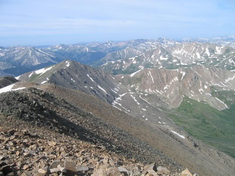
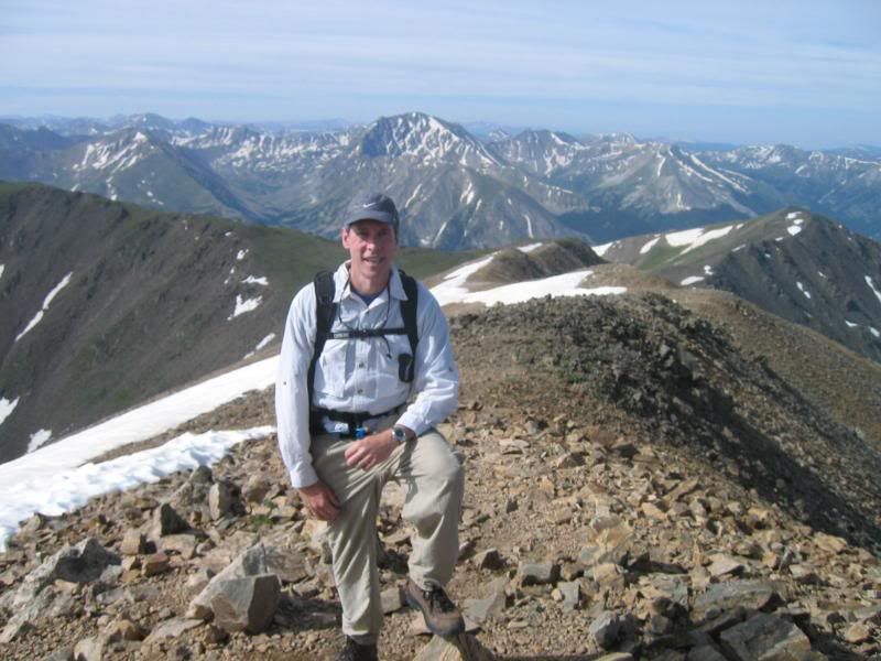
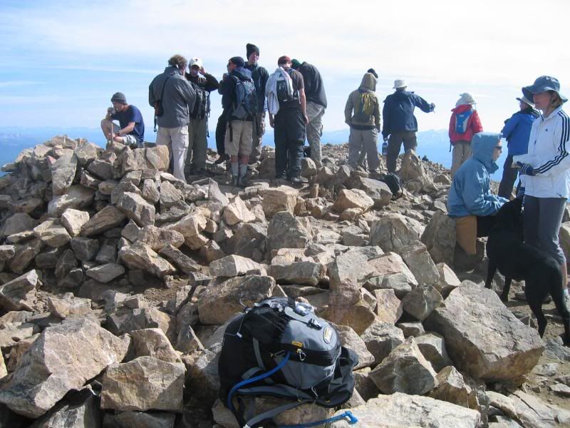
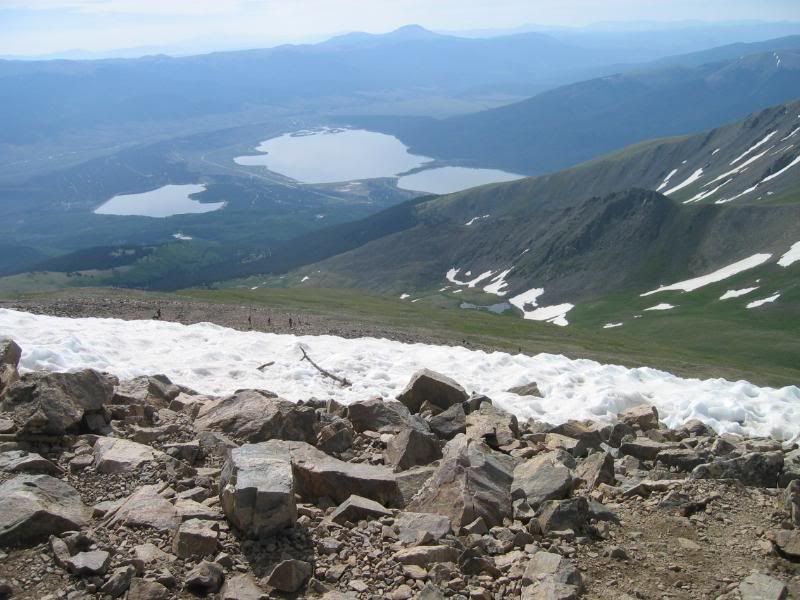
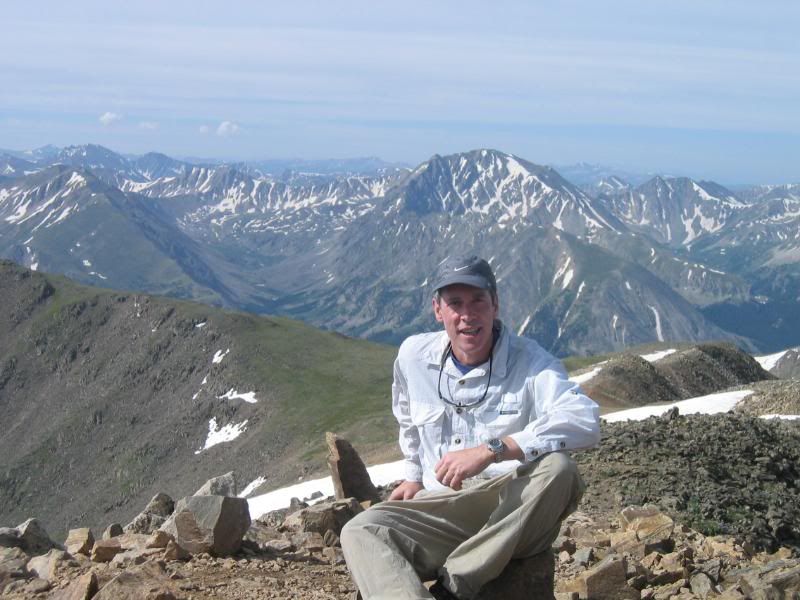
Thanks Jim. I already did Elbert 3 years ago so I don't need to do it again! It was pretty long and kind of hard for a novice like myself. We acclimated for a day at Twin Lakes, ate dinner in Leadville, and started very early in the morning the next day. Awesome scenery!
It was crowded at the top!
Snow in the summer on Mt Elbert
Time for a seat...
It was crowded at the top!
Snow in the summer on Mt Elbert
Time for a seat...