Any 993'ers want to meet at a state highpoint-I'll be at MS, AL & FL Nov 20th weekend
 11-06-2010, 04:32 PM
#1
Rennlist Member
Thread Starter
Gents, I'm doing another state high point trip leaving DC around 4pm on Nov 19th, getting to Mississippi's High Point around 2-3pm on Saturday the 20th. I should be at Alabama's highest point the next morning around breakfast time. Florida's high point is about 5 hours from here so I should be there around 2-3pm or so on Sunday  .
.
If interested, just PM me and I can get your cell phone # and call when I'm close. Maybe it'll work out! A very... mini-meet. Your 993 and my daily driver.
After this trip I'll be at 35 state high points. Only 15 to go after that. Planning to fly out to Tulsa OK in around May when the snows melt to do OK, NW, KS, SD and ND's highest points. Then I'll only have 10 to go.
I'll be driving 3000+ miles on this trip, taking the BMW this time again. After Florida's high point I'll head 10 hour straight to Miami to see my sister for Thanksgiving and her family. I'll be on some fairly nasty, pot holed dirt roads in Mississippi so I'm definitely not taking the 993. Plus, the BMW is a much better road car with the XM radio, heated seats for back pain comfort relief, and I need a 4 door when I get to Miami so I can take them around town for once in my own car! They're always driving me everywhere when I visit. It'll be fun to shuttle them around. I've never driven this far in my life, and certainly never alone. Very excited.
Here's the trip notes for the high points that help me find these spots and give me a bit of info through the "just back" reports:
MISSISSIPPI –
806 ft From the intersection of US-72 & SR-25 south of Iuka:
South Side - Exit US-72 and turn South (L) onto SR-25. - Drive 0.1 mi South and turn West (R) onto CR-187 (Fairground Rd). - Follow CR-187 as it curves 1.2 mi South and turn West (R) on CR-176. - Drive 0.7 mi on CR-176 and turn North (R) onto a good dirt road beside a residence. - Follow the steep road as it curves 1.0 mi up to the summit of Woodall Mountain.
North Side - Continue West on US-72 for 1.3 mi and crossover to the South (L) onto Mt. Gilead Rd. - Follow this paved road as it curves back West for 0.6 mi to CR-233. - Turn South (L) on CR-233 and continue 0.5 mi to a trailhead with a metal gate obstructing car access.
The South Side route is an open public easement to the summit, which is occasionally gated. If the gate is closed, simply hike the 1.0 mi and ~200 ft up to the top.
The North Ridge trail is surrounded by private land owned by the Tombigbee Hunting Club. Based on the placement of the "No Trespassing" signs, however, it appears that access is legal along the road/trail.
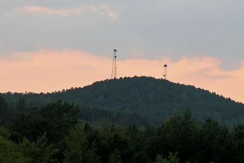
Woodall Mountain, the highest point in the state of Mississippi, is located just off Mississippi Highway 25, south of Iuka. The summit is marked with a National Geodetic Survey triangulation station disk and three radio towers. A sign cautions visitors to prepare for a steep, unpaved, and rocky inclined road approximately a mile in length to the summit.
Atop the hill there is a picnic table and a gravel circle allowing parking room for several vehicles. At the base of the hill to the east are the town of Iuka’s Little League and Youth Softball fields adjacent to the Tishomingo County Fair Grounds. Immediately to the south lies Woodall Mountain Estates, a subdivision with approximately 75 houses placed around a large lake.
Until 1998 an observation tower stood atop the hill in the middle of the gravel circle. A climb to the top gave an encompassing view of the surrounding area, and was an excellent vantage point to watch the town of Iuka’s fireworks displays. By the time of the towers' removal in 1998 some steps up the tower had rotted and the tower itself showed signs of age.
The height of Woodall Mountain is often lampooned by locals. Some nearby stores sell souvenir t-shirts with the phrase "Ski Woodall". However, the mountain does rise prominently above the surrounding terrain, is visible for several miles, and provides a good view of the surrounding countryside.
**Got up at 5 AM to get my 9th state HP and drove it in from Muscle Shoals like the "Sweet Home Alabama" songs says..........i had planned a neat way up from USGS map ( i hate drive ups) you have to earn them all..plus why not get ever opportunity to excercise?...my intended route was a southerly climb from near the Kirk Cem. 3 miles and getting 436 feet vertical at least a nice quick run up the hill but i could not find the trail head! ughhhhhhh since i had to get to Memphis for a work meeting i went up the convential way BUT i did not drive it.
Parking at the small pond near CO Rd 185 (the caly gravel road to the summit) i started downsteam at around EL 600 (other side of road) and hiked up the road. About 200 hundred yards i was greeted by a pack of large dogs running in pack that looked me over. Reading their body language as confident but not agressive i grabbed a large pine branch and carried it like Bufford Pusser right past them and conitued the 1 mile up the summit. There are many turns and some dips but i summitted quickly the 1 mile in like 13 minutes, took a proof picture or two and came down with a sprained ankle (rolled it on the way up) and was back to the car in 29 minutes for the 2 miles.
This is no mountain. It is a hill of clay. There is one nice view down the power line showing it does have some fall, but this is not a peak you do for view or challenge - but to cross it off your list. This route has a total vertical gain (up and back) of around 320 feet - not much excercise but beats a drive up!
**Walked about half way up the dirt road to the summit after driving half way up. It's not the most beautiful hike due to the logging, but it was ok.
** I stood on the unimpressive summit of Woodall Mountain, the highest point in Mississippi. There was a view off of one side of the mountain, but mostly there was just trees and radio towers. There was a benchmark showing the elevation but no register to sign.
ALABAMA

Near the high point

- Standing 2,407 ft. above sea level, it is no wonder why the local Creek Indians named this place “Chaha,” meaning high place. Driving Directions to Cheaha Mountain
From the East
Take Exit 191 from Interstate 20. Proceed South on US Route 431 for approximately 3.5 miles. Turn right onto State Route 281. Proceed South on State Route 281 for approximately 12.5 miles. Turn right into Cheaha State Park. There is a gate and an information booth right after you turn. As of 2003, the entrance fee was $1.00 per person. The highpoint is about .5 miles from the entrance on a paved road. There is a tower building on the summit.
From the West
Same as directions from the East. There is no advantage to exiting Interstate 20 until you reach Exit 191. This can be discovered this the hard way.
***From Florida to Alabama high point, weather was cold, rainy and windy at the top. No was around to snap my picture. Camp ground just below the high point.***
Hiking Directions from Trail Head to Cheaha Mountain Summit
There is parking right near the summit tower. It is a short walk from the parking to thew summit. There is a United States Geological Survey (USGS) marker in front of the tower entrance, but the actual highpoint is probably to the left of the building.
Approximate round trip hiking time: Less than five minutes
Lovely high point. Make sure you stop at the Cheaha Mountain Restaurant. I was on a time crunch (had to get back to Atlanta) so I didn't eat there, but the views were awesome. High point has a tower built by the Civilian Conservation Corps. Great views from up top. Benchmark is in the middle of the stone walkway going into the tower. Nice bouldering on a few boulders to the west of the tower.
Cheaha Mountain is a drive up highpoint. The best time to visit Cheaha Mountain is during daylight hours. it may be inaccessible at nighttime hours due to a locked gate.
It is located a few miles north-west of Delta in scenic Cheaha State Park, which contains a lodge, restaurant, and other amenities.
The highest point is marked with a USGS marker (photo below) in front of Bunker Tower, a stone Civilian Conservation Corps building with an observation deck on top. The CCC also constructed a road to Cheaha, but the road has been closed for years. The old road is locally referred to as the "CC Road" and contains interesting, inaccessible ruins. Near the peak is Bald Rock, which was recently improved with a wheelchair-accessible wooden walkway that provides an impressive overlook of the surrounding region. The entire area gives an impression of being at a much higher elevation than it actually is, in part because of the relatively low elevation of the adjacent area to the west.
The mountain also has the unique distinction of being the highest geographical point in the eastern portion of the Sun Belt (south of Interstate 20, and north of the Gulf of Mexico).
The mountain is now more famous for being a romantic getaway with individual chalets with huge windows near the summit as well as a swimming pool less than a mile from the summit. The big draw in the immediate area is the Talladega Motor Speedway.
The exit for the park was clearly marked on the interstate and the Skyway Motorway (Highway 49) was much more beautiful than I expected with commanding views.
We had gained an hour thanks to crossing into the Central Time Zone at the Alabama-Georgia border and I was concernd about arriving before the park official 8 a.m. opening time.
However, these fears proved pointless as we neared the summit with its chalet/restaurant complex and directions to numerous camping facilities (which were suprisingly full on this winter day). A sign asked for a voluntary $1 contribution.
Still a brochure says the gates are locked from 9 p.m. to 8 a.m. and that you need to contact the Park to get combinations.
Although the day before temperature was unseasonably in the 80's prompting the daffodils to bloom on the summit, it was bitterly cold with strong winds on the actual summit and temperatures enough to ice up our windows on this day.
We passed a couple soft drink machines while climbing the Civilian Conservation Corps tower with to its observation deck.
While we feasted over cheese grits and biscuits and gravy we marveled at the winter package for the closed enclosed cottages up here -- $40/night.
We happily chose not to return the way we came. Instead, we traveled on to the town of Talladega. The road was not as well maintained and we literally did not encounter a single car for 10 miles. For this we were rewarded with spying a bobcat and a myiad of the gigantic pileated woodpeckers.
FLORIDA


- Britton Hill is the highest 'natural' point in the state of Florida, USA, with a summit elevation of 345 feet (106 meters) above mean sea level. Britton Hill is one of the few flatland highpoints, As you drive through the tiny town of Paxton (just south of the state line), you'll see signs that point the way.
To get to Britton Hill is not complicated. Take I-10 on the Florida panhandle from either direction, and exit at rt. 331, just south of De Funiak Springs. Take 331 North for about 20 miles until you see a sign on the right pointing to the Florida highpoint. From the sign, it is about 3 miles to the parking lot. Before you reach it, you go up a steep hill, at the top of which, on the left side of the road, is a sign indicating the highpoint parking area. Park at the trailhead, and walk several yards to a large stone marker that indicates the highpoint. There is a nature trail beyond the highpoint that offers some hiking.
Many Florida skyscrapers are taller; as of 2010, the roof of the Four Seasons Hotel Miami is the highest non-natural point in Florida. Topping out at 789 feet, the tower is more than twice as high as Britton Hill. Britton Hill is the lowest state highpoint in the United States, 103 feet (31 m) lower than the next lowest highpoint, Ebright Azimuth in Delaware. It is even lower than the highest point in Washington D.C., Tenleytown, at 429 feet (125 m). It is located at 30� 59' 18″N, 86� 16' 55″W in northern Walton County near the town of Lakewood, Florida.
The hill is located just off County Road 285 about 2 miles southeast of Florala, Alabama. A small park called Lakewood Park marks the high point and features a monument, trails and an information board.
**50 feet from the parking area near the Alabama-Florida border.
**A highpointer will go anywhere these days...even Florida! No, Space Mountain is not the highest mountain in Florida, although it is the most expensive!
Out West, on the Florida panhandle, is Britton Hill - the real Florida highpoint. It is also the lowest elevated state highpoint in the United States. In fact, whereever you are sitting right now, is probably at a higher elevation than Britton Hill. The question is why bother visiting the area? First off, it is a state highpoint, but second, it is part of a unique area of the nation. Situated less than 50 miles from the Gulf of Mexico, small, hilly roads lead up to Britton Hill, just below the Alabama state line. Britton Hill is part of a small forest, about 50 feet above farm land, that looks more like something you would find in Michigan than you would find in Florida. Although it is in Florida, it is in Central time zone, because it is so far west in the panhandle. If you drove straight north up the country, you would be in Indiana. Britton Hill is named for the retired postmistress of Lakewood and is located in a county park. It is located in Paxton, Florida.
Merge onto I-270 LOCAL S. 2.8 mi Map | Avoid
6. I-270 LOCAL S becomes I-270 S. 1.0 mi Map | Avoid
7. Keep RIGHT to take I-270-SPUR S toward I-270/WASHINGTON/I-495/NORTHERN VIRGINIA. 2.0 mi Map | Avoid
8. I-270-SPUR S becomes I-495 S/CAPITAL BELTWAY/I-495 OUTERLOOP (Crossing into VIRGINIA). 9.9 mi Map | Avoid
9. Merge onto I-66 W via EXIT 49 toward MANASSAS/FRONT ROYAL. 64.5 mi Map | Avoid
10. Merge onto I-81 S via EXIT 1A on the LEFT toward ROANOKE (Crossing into TENNESSEE). 376.2 mi Map | Avoid
11. Merge onto I-40 W via EXIT 1B toward KNOXVILLE. 53.5 mi Map | Avoid
12. Keep LEFT to take I-75 S via EXIT 368 toward CHATTANOOGA. 83.4 mi Map | Avoid
13. Merge onto I-24 W via EXIT 2 toward CHATTANOOGA/I-59/BIRMINGHAM (Passing through GEORGIA, then crossing into TENNESSEE). 33.8 mi Map | Avoid
14. Take the US-64/US-72 exit, EXIT 152, toward US-41/KIMBALL/S PITTSBURG. 0.1 mi Map | Avoid
15. Merge onto US-72 W toward S PITTSBURG/RUSSELL CAVE NATL MONUMENT (Crossing into ALABAMA). 71.0 mi Map | Avoid
16. Merge onto I-565 W via the exit on the LEFT. 21.5 mi Map | Avoid
17. I-565 W becomes US-72-ALT W/AL-20 W. 5.3 mi Map | Avoid
18. Turn SLIGHT RIGHT onto WILSON ST NE/US-72-ALT/AL-20. Continue to follow US-72-ALT W/AL-20 W. 41.5 mi Map | Avoid
19. US-72-ALT W/AL-20 W becomes US-72 W (Crossing into MISSISSIPPI). 31.8 mi Map | Avoid
20. Take the MS-25 ramp toward IUKA/FULTON. 0.2 mi Map | Avoid
21. Keep RIGHT at the fork to go on VETERANS' MEMORIAL DR/MS-25 N. 0.2 mi Map | Avoid
22. Turn SLIGHT RIGHT onto BATTLEGROUND DR/MS-25-BR. Continue to follow MS-25-BR. 2.9 mi Map | Avoid
23. Welcome to IUKA, MS 38852. Map
A to B Travel Estimate: 13 hours 19 minutes / 807.01 miles
Iuka, MS 38852 Edit
Directions from B to C:
1. Start out going SOUTH on CONSTITUTION DR/MS-25-BR toward CEDAR ST. Continue to follow MS-25-BR. 2.9 mi Map
2. Turn LEFT onto VETERANS' MEMORIAL DR/MS-25 S. 0.4 mi Map | Avoid
3. Merge onto US-72 E via the ramp on the LEFT (Crossing into ALABAMA). 32.1 mi Map | Avoid
4. US-72 E becomes AL-157 S. 59.5 mi Map | Avoid
5. Merge onto I-65 S toward BIRMINGHAM. 49.5 mi Map | Avoid
6. Merge onto I-20 E/I-59 N via EXIT 261A on the LEFT toward ATLANTA/GADSDEN. 5.2 mi Map | Avoid
7. Merge onto I-20 E via EXIT 130 toward ATLANTA. 61.7 mi Map | Avoid
8. Take the US-431 exit, EXIT 191, toward US-78. 0.2 mi Map | Avoid
9. Merge onto US-431 S/AL-1 toward HOLLIS. 8.7 mi Map | Avoid
10. Turn RIGHT onto AL-9. 7.4 mi Map | Avoid
11. Turn LEFT onto LEES BRIDGE RD/CR-47. 0.7 mi Map | Avoid
12. Turn SLIGHT LEFT onto CR-260. 0.5 mi Map | Avoid
13. Welcome to DELTA, AL 36258. Map
There are 0.2 miles between your ending location and the end of your driving directions. Use local maps to get from the end of your route to your ending location.
B to C Travel Estimate: 3 hours 58 minutes / 228.88 miles
Delta, AL 36258 Edit
Online Offers: Motels in Delta Delta Restaurants Alabama Auto Insurance
Directions from C to D:
There are 0.2 miles between your starting location and the beginning of your driving directions. Use local maps to get from your starting location to the beginning of your route.
1. Start out going WEST on CR-260 toward LEES BRIDGE RD/CR-47. 0.5 mi Map
2. Turn SLIGHT RIGHT onto LEES BRIDGE RD/CR-47. 0.7 mi Map | Avoid
3. Turn LEFT onto AL-9. 10.7 mi Map | Avoid
4. Turn LEFT onto AL-9/1ST AVE S. Continue to follow AL-9. 5.7 mi Map | Avoid
5. Turn LEFT onto AL-9/1ST ST. Continue to follow AL-9 S. 58.7 mi Map | Avoid
6. Turn LEFT onto US-231 S/AL-21 S/AL-53 S/AL-9 S. 11.6 mi Map | Avoid
7. Merge onto US-231 S/AL-21 S/AL-53 S via the ramp on the LEFT. 7.6 mi Map | Avoid
8. Turn LEFT onto US-231 S/US-82 E/TROY HWY/AL-53 S/AL-6 S. Continue to follow US-231 S/AL-53 S. 43.3 mi Map | Avoid
9. Turn SLIGHT RIGHT onto AL-87 S. 28.4 mi Map | Avoid
10. Turn RIGHT onto US-84/AL-12/AL-189/HICKMAN ST. 0.4 mi Map | Avoid
11. Turn RIGHT onto US-84/HICKMAN ST/AL-12. Continue to follow US-84. 5.4 mi Map | Avoid
12. Turn LEFT onto US-84 W/AL-12 W. 8.3 mi Map | Avoid
13. Turn LEFT onto VETERANS MEMORIAL PKWY/US-331 S. 5.5 mi Map | Avoid
14. Turn LEFT onto US-331 S/AL-9 S. 17.8 mi Map | Avoid
15. Turn LEFT onto US-331/5TH AVE/AL-55/AL-9/CR-4. Continue to follow US-331/5TH AVE/AL-9/CR-4. 1.4 mi Map | Avoid
16. Turn RIGHT onto E 3RD ST/US-331/AL-9. Continue to follow US-331 (Crossing into FLORIDA). 16.5 mi Map | Avoid
17. Turn RIGHT onto KINGS LAKE RD. 0.9 mi Map | Avoid
18. Turn LEFT onto PARADISE ISLAND DR. 0.2 mi Map | Avoid
19. Turn RIGHT onto WREN DR. 0.2 mi Map | Avoid
20. Turn LEFT to stay on WREN DR. 0.1 mi Map | Avoid
21. Turn RIGHT onto KINGS LAKE BLVD. 1.1 mi Map | Avoid
22. Welcome to DEFUNIAK SPRINGS, FL 32433. Map
There are 0.1 miles between your ending location and the end of your driving directions. Use local maps to get from the end of your route to your ending location.
C to D Travel Estimate: 4 hours 33 minutes / 224.84 miles
Defuniak Springs, FL 32433 Edit
Online Offers: Motels in Defuniak Springs Defuniak Springs Restaurants Florida Auto Insurance
Directions from D to E:
There are 0.1 miles between your starting location and the beginning of your driving directions. Use local maps to get from your starting location to the beginning of your route.
1. Start out going SOUTH on KINGS LAKE BLVD toward PIPER LANDING RD. 0.1 mi Map
2. Turn LEFT onto PIPER LANDING RD. 0.4 mi Map | Avoid
3. Turn RIGHT onto BELL DR. 0.4 mi Map | Avoid
4. Turn SLIGHT RIGHT onto CASWELL RD. 2.3 mi Map | Avoid
5. Turn RIGHT onto US-331. 1.9 mi Map | Avoid
6. Turn LEFT onto US-90 E/US-331 S/SR-10 E/OLD SPANISH TRL. 1.9 mi Map | Avoid
7. Turn RIGHT onto US-331 S/FREEPORT RD/SR-83 S. 2.2 mi Map | Avoid
8. Merge onto I-10 E via the ramp on the LEFT toward TALLAHASSEE. 211.3 mi Map | Avoid
9. Merge onto I-75 S via EXIT 296A toward TAMPA. 107.9 mi Map | Avoid
10. Merge onto FLORIDA'S TURNPIKE S via EXIT 328 on the LEFT toward ORLANDO (Portions toll). 219.3 mi Map | Avoid
11. Take FLORIDA'S TURNPIKE S (Portions toll). 42.3 mi Map | Avoid
12. Keep RIGHT to take FLORIDA'S TURNPIKE S/SR-821 S toward HOMESTEAD (Portions toll). 35.3 mi Map | Avoid
13. Take EXIT 11 toward CUTLER RIDGE BLVD/SW 216TH ST. 0.2 mi Map | Avoid
14. Stay STRAIGHT to go onto FLORIDA'S TURNPIKE S. 0.5 mi Map | Avoid
15. Turn LEFT onto SW 216TH ST/HAINLIN MILL DR. 1.2 mi Map | Avoid
D to E Travel Estimate: 9 hours 38 minutes / 627.43 miles
Cutler Bay, FL 33189-3745
Directions from E to F:
1.
2. Turn LEFT onto SW 215TH LN. 0.0 mi Map | Avoid
3. Turn RIGHT onto SW 94TH AVE. 0.0 mi Map | Avoid
4. Turn RIGHT onto SW 216TH ST/HAINLIN MILL DR. 1.1 mi Map | Avoid
5. Take the FLORIDA'S TURNPIKE NORTH ramp. 0.1 mi Map | Avoid
6. Turn SLIGHT RIGHT onto FLORIDA'S TURNPIKE N. 0.5 mi Map | Avoid
7. Merge onto FLORIDA'S TURNPIKE N/SR-821 N (Portions toll). 19.1 mi Map | Avoid
8. Merge onto FLORIDA'S TURNPIKE N (Portions toll). 122.0 mi Map | Avoid
9. Merge onto OKEECHOBEE RD/SR-70 E via EXIT 152 toward I-95/FT PIERCE/US-1. 1.2 mi Map | Avoid
10. Merge onto I-95 N toward DAYTONA BCH. 208.9 mi Map | Avoid
11. Merge onto SR-9A N via EXIT 337 toward JAX BEACHES. 26.0 mi Map | Avoid
12. Merge onto I-95 N via EXIT 35B toward SAVANNAH (Passing through GEORGIA, SOUTH CAROLINA, and NORTH CAROLINA, then crossing into VIRGINIA). 560.2 mi Map | Avoid
13. Merge onto I-295 N via EXIT 46 toward WASHINGTON/RICHMOND INT'L AIRPORT. 42.0 mi Map | Avoid
14. Merge onto I-95 N via EXIT 43A on the LEFT toward WASHINGTON. 85.8 mi Map | Avoid
15. Keep RIGHT via EXIT 170A-B toward I-395 N/WASHINGTON/I-495 N/TYSONS CORNER. 0.6 mi Map | Avoid
16. Merge onto I-495 N/CAPITAL BELTWAY/I-495 INNERLOOP via EXIT 170B toward TYSONS CORNER (Crossing into MARYLAND). 18.8 mi Map | Avoid
17. Keep LEFT to take I-270-SPUR N via EXIT 38 toward ROCKVILLE/FREDERICK. 2.0 mi Map | Avoid
18. I-270-SPUR N becomes I-270 N. 3.1 mi Map | Avoid
19. Merge onto I-270 LOCAL N via EXIT 6 toward MD-28/W MONTGOMERY AVE. 0.6 mi Map | Avoid
20. Take the MD-28 W/W MONTGOMERY AVE exit, EXIT 6B, toward DARNESTOWN. 0.2 mi Map | Avoid
21. Turn SLIGHT RIGHT onto W MONTGOMERY AVE/MD-28 W. Continue to follow MD-28 W.
Total Travel Estimate: 48 hours 40 minutes / 2985.81 miles
.If interested, just PM me and I can get your cell phone # and call when I'm close. Maybe it'll work out! A very... mini-meet. Your 993 and my daily driver.
After this trip I'll be at 35 state high points. Only 15 to go after that. Planning to fly out to Tulsa OK in around May when the snows melt to do OK, NW, KS, SD and ND's highest points. Then I'll only have 10 to go.
I'll be driving 3000+ miles on this trip, taking the BMW this time again. After Florida's high point I'll head 10 hour straight to Miami to see my sister for Thanksgiving and her family. I'll be on some fairly nasty, pot holed dirt roads in Mississippi so I'm definitely not taking the 993. Plus, the BMW is a much better road car with the XM radio, heated seats for back pain comfort relief, and I need a 4 door when I get to Miami so I can take them around town for once in my own car! They're always driving me everywhere when I visit. It'll be fun to shuttle them around. I've never driven this far in my life, and certainly never alone. Very excited.
Here's the trip notes for the high points that help me find these spots and give me a bit of info through the "just back" reports:
MISSISSIPPI –
806 ft From the intersection of US-72 & SR-25 south of Iuka:
South Side - Exit US-72 and turn South (L) onto SR-25. - Drive 0.1 mi South and turn West (R) onto CR-187 (Fairground Rd). - Follow CR-187 as it curves 1.2 mi South and turn West (R) on CR-176. - Drive 0.7 mi on CR-176 and turn North (R) onto a good dirt road beside a residence. - Follow the steep road as it curves 1.0 mi up to the summit of Woodall Mountain.
North Side - Continue West on US-72 for 1.3 mi and crossover to the South (L) onto Mt. Gilead Rd. - Follow this paved road as it curves back West for 0.6 mi to CR-233. - Turn South (L) on CR-233 and continue 0.5 mi to a trailhead with a metal gate obstructing car access.
The South Side route is an open public easement to the summit, which is occasionally gated. If the gate is closed, simply hike the 1.0 mi and ~200 ft up to the top.
The North Ridge trail is surrounded by private land owned by the Tombigbee Hunting Club. Based on the placement of the "No Trespassing" signs, however, it appears that access is legal along the road/trail.
Woodall Mountain, the highest point in the state of Mississippi, is located just off Mississippi Highway 25, south of Iuka. The summit is marked with a National Geodetic Survey triangulation station disk and three radio towers. A sign cautions visitors to prepare for a steep, unpaved, and rocky inclined road approximately a mile in length to the summit.
Atop the hill there is a picnic table and a gravel circle allowing parking room for several vehicles. At the base of the hill to the east are the town of Iuka’s Little League and Youth Softball fields adjacent to the Tishomingo County Fair Grounds. Immediately to the south lies Woodall Mountain Estates, a subdivision with approximately 75 houses placed around a large lake.
Until 1998 an observation tower stood atop the hill in the middle of the gravel circle. A climb to the top gave an encompassing view of the surrounding area, and was an excellent vantage point to watch the town of Iuka’s fireworks displays. By the time of the towers' removal in 1998 some steps up the tower had rotted and the tower itself showed signs of age.
The height of Woodall Mountain is often lampooned by locals. Some nearby stores sell souvenir t-shirts with the phrase "Ski Woodall". However, the mountain does rise prominently above the surrounding terrain, is visible for several miles, and provides a good view of the surrounding countryside.
**Got up at 5 AM to get my 9th state HP and drove it in from Muscle Shoals like the "Sweet Home Alabama" songs says..........i had planned a neat way up from USGS map ( i hate drive ups) you have to earn them all..plus why not get ever opportunity to excercise?...my intended route was a southerly climb from near the Kirk Cem. 3 miles and getting 436 feet vertical at least a nice quick run up the hill but i could not find the trail head! ughhhhhhh since i had to get to Memphis for a work meeting i went up the convential way BUT i did not drive it.
Parking at the small pond near CO Rd 185 (the caly gravel road to the summit) i started downsteam at around EL 600 (other side of road) and hiked up the road. About 200 hundred yards i was greeted by a pack of large dogs running in pack that looked me over. Reading their body language as confident but not agressive i grabbed a large pine branch and carried it like Bufford Pusser right past them and conitued the 1 mile up the summit. There are many turns and some dips but i summitted quickly the 1 mile in like 13 minutes, took a proof picture or two and came down with a sprained ankle (rolled it on the way up) and was back to the car in 29 minutes for the 2 miles.
This is no mountain. It is a hill of clay. There is one nice view down the power line showing it does have some fall, but this is not a peak you do for view or challenge - but to cross it off your list. This route has a total vertical gain (up and back) of around 320 feet - not much excercise but beats a drive up!
**Walked about half way up the dirt road to the summit after driving half way up. It's not the most beautiful hike due to the logging, but it was ok.
** I stood on the unimpressive summit of Woodall Mountain, the highest point in Mississippi. There was a view off of one side of the mountain, but mostly there was just trees and radio towers. There was a benchmark showing the elevation but no register to sign.
ALABAMA
Near the high point
- Standing 2,407 ft. above sea level, it is no wonder why the local Creek Indians named this place “Chaha,” meaning high place. Driving Directions to Cheaha Mountain
From the East
Take Exit 191 from Interstate 20. Proceed South on US Route 431 for approximately 3.5 miles. Turn right onto State Route 281. Proceed South on State Route 281 for approximately 12.5 miles. Turn right into Cheaha State Park. There is a gate and an information booth right after you turn. As of 2003, the entrance fee was $1.00 per person. The highpoint is about .5 miles from the entrance on a paved road. There is a tower building on the summit.
From the West
Same as directions from the East. There is no advantage to exiting Interstate 20 until you reach Exit 191. This can be discovered this the hard way.
***From Florida to Alabama high point, weather was cold, rainy and windy at the top. No was around to snap my picture. Camp ground just below the high point.***
Hiking Directions from Trail Head to Cheaha Mountain Summit
There is parking right near the summit tower. It is a short walk from the parking to thew summit. There is a United States Geological Survey (USGS) marker in front of the tower entrance, but the actual highpoint is probably to the left of the building.
Approximate round trip hiking time: Less than five minutes
Lovely high point. Make sure you stop at the Cheaha Mountain Restaurant. I was on a time crunch (had to get back to Atlanta) so I didn't eat there, but the views were awesome. High point has a tower built by the Civilian Conservation Corps. Great views from up top. Benchmark is in the middle of the stone walkway going into the tower. Nice bouldering on a few boulders to the west of the tower.
Cheaha Mountain is a drive up highpoint. The best time to visit Cheaha Mountain is during daylight hours. it may be inaccessible at nighttime hours due to a locked gate.
It is located a few miles north-west of Delta in scenic Cheaha State Park, which contains a lodge, restaurant, and other amenities.
The highest point is marked with a USGS marker (photo below) in front of Bunker Tower, a stone Civilian Conservation Corps building with an observation deck on top. The CCC also constructed a road to Cheaha, but the road has been closed for years. The old road is locally referred to as the "CC Road" and contains interesting, inaccessible ruins. Near the peak is Bald Rock, which was recently improved with a wheelchair-accessible wooden walkway that provides an impressive overlook of the surrounding region. The entire area gives an impression of being at a much higher elevation than it actually is, in part because of the relatively low elevation of the adjacent area to the west.
The mountain also has the unique distinction of being the highest geographical point in the eastern portion of the Sun Belt (south of Interstate 20, and north of the Gulf of Mexico).
The mountain is now more famous for being a romantic getaway with individual chalets with huge windows near the summit as well as a swimming pool less than a mile from the summit. The big draw in the immediate area is the Talladega Motor Speedway.
The exit for the park was clearly marked on the interstate and the Skyway Motorway (Highway 49) was much more beautiful than I expected with commanding views.
We had gained an hour thanks to crossing into the Central Time Zone at the Alabama-Georgia border and I was concernd about arriving before the park official 8 a.m. opening time.
However, these fears proved pointless as we neared the summit with its chalet/restaurant complex and directions to numerous camping facilities (which were suprisingly full on this winter day). A sign asked for a voluntary $1 contribution.
Still a brochure says the gates are locked from 9 p.m. to 8 a.m. and that you need to contact the Park to get combinations.
Although the day before temperature was unseasonably in the 80's prompting the daffodils to bloom on the summit, it was bitterly cold with strong winds on the actual summit and temperatures enough to ice up our windows on this day.
We passed a couple soft drink machines while climbing the Civilian Conservation Corps tower with to its observation deck.
While we feasted over cheese grits and biscuits and gravy we marveled at the winter package for the closed enclosed cottages up here -- $40/night.
We happily chose not to return the way we came. Instead, we traveled on to the town of Talladega. The road was not as well maintained and we literally did not encounter a single car for 10 miles. For this we were rewarded with spying a bobcat and a myiad of the gigantic pileated woodpeckers.
FLORIDA
- Britton Hill is the highest 'natural' point in the state of Florida, USA, with a summit elevation of 345 feet (106 meters) above mean sea level. Britton Hill is one of the few flatland highpoints, As you drive through the tiny town of Paxton (just south of the state line), you'll see signs that point the way.
To get to Britton Hill is not complicated. Take I-10 on the Florida panhandle from either direction, and exit at rt. 331, just south of De Funiak Springs. Take 331 North for about 20 miles until you see a sign on the right pointing to the Florida highpoint. From the sign, it is about 3 miles to the parking lot. Before you reach it, you go up a steep hill, at the top of which, on the left side of the road, is a sign indicating the highpoint parking area. Park at the trailhead, and walk several yards to a large stone marker that indicates the highpoint. There is a nature trail beyond the highpoint that offers some hiking.
Many Florida skyscrapers are taller; as of 2010, the roof of the Four Seasons Hotel Miami is the highest non-natural point in Florida. Topping out at 789 feet, the tower is more than twice as high as Britton Hill. Britton Hill is the lowest state highpoint in the United States, 103 feet (31 m) lower than the next lowest highpoint, Ebright Azimuth in Delaware. It is even lower than the highest point in Washington D.C., Tenleytown, at 429 feet (125 m). It is located at 30� 59' 18″N, 86� 16' 55″W in northern Walton County near the town of Lakewood, Florida.
The hill is located just off County Road 285 about 2 miles southeast of Florala, Alabama. A small park called Lakewood Park marks the high point and features a monument, trails and an information board.
**50 feet from the parking area near the Alabama-Florida border.
**A highpointer will go anywhere these days...even Florida! No, Space Mountain is not the highest mountain in Florida, although it is the most expensive!
Out West, on the Florida panhandle, is Britton Hill - the real Florida highpoint. It is also the lowest elevated state highpoint in the United States. In fact, whereever you are sitting right now, is probably at a higher elevation than Britton Hill. The question is why bother visiting the area? First off, it is a state highpoint, but second, it is part of a unique area of the nation. Situated less than 50 miles from the Gulf of Mexico, small, hilly roads lead up to Britton Hill, just below the Alabama state line. Britton Hill is part of a small forest, about 50 feet above farm land, that looks more like something you would find in Michigan than you would find in Florida. Although it is in Florida, it is in Central time zone, because it is so far west in the panhandle. If you drove straight north up the country, you would be in Indiana. Britton Hill is named for the retired postmistress of Lakewood and is located in a county park. It is located in Paxton, Florida.
Merge onto I-270 LOCAL S. 2.8 mi Map | Avoid
6. I-270 LOCAL S becomes I-270 S. 1.0 mi Map | Avoid
7. Keep RIGHT to take I-270-SPUR S toward I-270/WASHINGTON/I-495/NORTHERN VIRGINIA. 2.0 mi Map | Avoid
8. I-270-SPUR S becomes I-495 S/CAPITAL BELTWAY/I-495 OUTERLOOP (Crossing into VIRGINIA). 9.9 mi Map | Avoid
9. Merge onto I-66 W via EXIT 49 toward MANASSAS/FRONT ROYAL. 64.5 mi Map | Avoid
10. Merge onto I-81 S via EXIT 1A on the LEFT toward ROANOKE (Crossing into TENNESSEE). 376.2 mi Map | Avoid
11. Merge onto I-40 W via EXIT 1B toward KNOXVILLE. 53.5 mi Map | Avoid
12. Keep LEFT to take I-75 S via EXIT 368 toward CHATTANOOGA. 83.4 mi Map | Avoid
13. Merge onto I-24 W via EXIT 2 toward CHATTANOOGA/I-59/BIRMINGHAM (Passing through GEORGIA, then crossing into TENNESSEE). 33.8 mi Map | Avoid
14. Take the US-64/US-72 exit, EXIT 152, toward US-41/KIMBALL/S PITTSBURG. 0.1 mi Map | Avoid
15. Merge onto US-72 W toward S PITTSBURG/RUSSELL CAVE NATL MONUMENT (Crossing into ALABAMA). 71.0 mi Map | Avoid
16. Merge onto I-565 W via the exit on the LEFT. 21.5 mi Map | Avoid
17. I-565 W becomes US-72-ALT W/AL-20 W. 5.3 mi Map | Avoid
18. Turn SLIGHT RIGHT onto WILSON ST NE/US-72-ALT/AL-20. Continue to follow US-72-ALT W/AL-20 W. 41.5 mi Map | Avoid
19. US-72-ALT W/AL-20 W becomes US-72 W (Crossing into MISSISSIPPI). 31.8 mi Map | Avoid
20. Take the MS-25 ramp toward IUKA/FULTON. 0.2 mi Map | Avoid
21. Keep RIGHT at the fork to go on VETERANS' MEMORIAL DR/MS-25 N. 0.2 mi Map | Avoid
22. Turn SLIGHT RIGHT onto BATTLEGROUND DR/MS-25-BR. Continue to follow MS-25-BR. 2.9 mi Map | Avoid
23. Welcome to IUKA, MS 38852. Map
A to B Travel Estimate: 13 hours 19 minutes / 807.01 miles
Iuka, MS 38852 Edit
Directions from B to C:
1. Start out going SOUTH on CONSTITUTION DR/MS-25-BR toward CEDAR ST. Continue to follow MS-25-BR. 2.9 mi Map
2. Turn LEFT onto VETERANS' MEMORIAL DR/MS-25 S. 0.4 mi Map | Avoid
3. Merge onto US-72 E via the ramp on the LEFT (Crossing into ALABAMA). 32.1 mi Map | Avoid
4. US-72 E becomes AL-157 S. 59.5 mi Map | Avoid
5. Merge onto I-65 S toward BIRMINGHAM. 49.5 mi Map | Avoid
6. Merge onto I-20 E/I-59 N via EXIT 261A on the LEFT toward ATLANTA/GADSDEN. 5.2 mi Map | Avoid
7. Merge onto I-20 E via EXIT 130 toward ATLANTA. 61.7 mi Map | Avoid
8. Take the US-431 exit, EXIT 191, toward US-78. 0.2 mi Map | Avoid
9. Merge onto US-431 S/AL-1 toward HOLLIS. 8.7 mi Map | Avoid
10. Turn RIGHT onto AL-9. 7.4 mi Map | Avoid
11. Turn LEFT onto LEES BRIDGE RD/CR-47. 0.7 mi Map | Avoid
12. Turn SLIGHT LEFT onto CR-260. 0.5 mi Map | Avoid
13. Welcome to DELTA, AL 36258. Map
There are 0.2 miles between your ending location and the end of your driving directions. Use local maps to get from the end of your route to your ending location.
B to C Travel Estimate: 3 hours 58 minutes / 228.88 miles
Delta, AL 36258 Edit
Online Offers: Motels in Delta Delta Restaurants Alabama Auto Insurance
Directions from C to D:
There are 0.2 miles between your starting location and the beginning of your driving directions. Use local maps to get from your starting location to the beginning of your route.
1. Start out going WEST on CR-260 toward LEES BRIDGE RD/CR-47. 0.5 mi Map
2. Turn SLIGHT RIGHT onto LEES BRIDGE RD/CR-47. 0.7 mi Map | Avoid
3. Turn LEFT onto AL-9. 10.7 mi Map | Avoid
4. Turn LEFT onto AL-9/1ST AVE S. Continue to follow AL-9. 5.7 mi Map | Avoid
5. Turn LEFT onto AL-9/1ST ST. Continue to follow AL-9 S. 58.7 mi Map | Avoid
6. Turn LEFT onto US-231 S/AL-21 S/AL-53 S/AL-9 S. 11.6 mi Map | Avoid
7. Merge onto US-231 S/AL-21 S/AL-53 S via the ramp on the LEFT. 7.6 mi Map | Avoid
8. Turn LEFT onto US-231 S/US-82 E/TROY HWY/AL-53 S/AL-6 S. Continue to follow US-231 S/AL-53 S. 43.3 mi Map | Avoid
9. Turn SLIGHT RIGHT onto AL-87 S. 28.4 mi Map | Avoid
10. Turn RIGHT onto US-84/AL-12/AL-189/HICKMAN ST. 0.4 mi Map | Avoid
11. Turn RIGHT onto US-84/HICKMAN ST/AL-12. Continue to follow US-84. 5.4 mi Map | Avoid
12. Turn LEFT onto US-84 W/AL-12 W. 8.3 mi Map | Avoid
13. Turn LEFT onto VETERANS MEMORIAL PKWY/US-331 S. 5.5 mi Map | Avoid
14. Turn LEFT onto US-331 S/AL-9 S. 17.8 mi Map | Avoid
15. Turn LEFT onto US-331/5TH AVE/AL-55/AL-9/CR-4. Continue to follow US-331/5TH AVE/AL-9/CR-4. 1.4 mi Map | Avoid
16. Turn RIGHT onto E 3RD ST/US-331/AL-9. Continue to follow US-331 (Crossing into FLORIDA). 16.5 mi Map | Avoid
17. Turn RIGHT onto KINGS LAKE RD. 0.9 mi Map | Avoid
18. Turn LEFT onto PARADISE ISLAND DR. 0.2 mi Map | Avoid
19. Turn RIGHT onto WREN DR. 0.2 mi Map | Avoid
20. Turn LEFT to stay on WREN DR. 0.1 mi Map | Avoid
21. Turn RIGHT onto KINGS LAKE BLVD. 1.1 mi Map | Avoid
22. Welcome to DEFUNIAK SPRINGS, FL 32433. Map
There are 0.1 miles between your ending location and the end of your driving directions. Use local maps to get from the end of your route to your ending location.
C to D Travel Estimate: 4 hours 33 minutes / 224.84 miles
Defuniak Springs, FL 32433 Edit
Online Offers: Motels in Defuniak Springs Defuniak Springs Restaurants Florida Auto Insurance
Directions from D to E:
There are 0.1 miles between your starting location and the beginning of your driving directions. Use local maps to get from your starting location to the beginning of your route.
1. Start out going SOUTH on KINGS LAKE BLVD toward PIPER LANDING RD. 0.1 mi Map
2. Turn LEFT onto PIPER LANDING RD. 0.4 mi Map | Avoid
3. Turn RIGHT onto BELL DR. 0.4 mi Map | Avoid
4. Turn SLIGHT RIGHT onto CASWELL RD. 2.3 mi Map | Avoid
5. Turn RIGHT onto US-331. 1.9 mi Map | Avoid
6. Turn LEFT onto US-90 E/US-331 S/SR-10 E/OLD SPANISH TRL. 1.9 mi Map | Avoid
7. Turn RIGHT onto US-331 S/FREEPORT RD/SR-83 S. 2.2 mi Map | Avoid
8. Merge onto I-10 E via the ramp on the LEFT toward TALLAHASSEE. 211.3 mi Map | Avoid
9. Merge onto I-75 S via EXIT 296A toward TAMPA. 107.9 mi Map | Avoid
10. Merge onto FLORIDA'S TURNPIKE S via EXIT 328 on the LEFT toward ORLANDO (Portions toll). 219.3 mi Map | Avoid
11. Take FLORIDA'S TURNPIKE S (Portions toll). 42.3 mi Map | Avoid
12. Keep RIGHT to take FLORIDA'S TURNPIKE S/SR-821 S toward HOMESTEAD (Portions toll). 35.3 mi Map | Avoid
13. Take EXIT 11 toward CUTLER RIDGE BLVD/SW 216TH ST. 0.2 mi Map | Avoid
14. Stay STRAIGHT to go onto FLORIDA'S TURNPIKE S. 0.5 mi Map | Avoid
15. Turn LEFT onto SW 216TH ST/HAINLIN MILL DR. 1.2 mi Map | Avoid
D to E Travel Estimate: 9 hours 38 minutes / 627.43 miles
Cutler Bay, FL 33189-3745
Directions from E to F:
1.
2. Turn LEFT onto SW 215TH LN. 0.0 mi Map | Avoid
3. Turn RIGHT onto SW 94TH AVE. 0.0 mi Map | Avoid
4. Turn RIGHT onto SW 216TH ST/HAINLIN MILL DR. 1.1 mi Map | Avoid
5. Take the FLORIDA'S TURNPIKE NORTH ramp. 0.1 mi Map | Avoid
6. Turn SLIGHT RIGHT onto FLORIDA'S TURNPIKE N. 0.5 mi Map | Avoid
7. Merge onto FLORIDA'S TURNPIKE N/SR-821 N (Portions toll). 19.1 mi Map | Avoid
8. Merge onto FLORIDA'S TURNPIKE N (Portions toll). 122.0 mi Map | Avoid
9. Merge onto OKEECHOBEE RD/SR-70 E via EXIT 152 toward I-95/FT PIERCE/US-1. 1.2 mi Map | Avoid
10. Merge onto I-95 N toward DAYTONA BCH. 208.9 mi Map | Avoid
11. Merge onto SR-9A N via EXIT 337 toward JAX BEACHES. 26.0 mi Map | Avoid
12. Merge onto I-95 N via EXIT 35B toward SAVANNAH (Passing through GEORGIA, SOUTH CAROLINA, and NORTH CAROLINA, then crossing into VIRGINIA). 560.2 mi Map | Avoid
13. Merge onto I-295 N via EXIT 46 toward WASHINGTON/RICHMOND INT'L AIRPORT. 42.0 mi Map | Avoid
14. Merge onto I-95 N via EXIT 43A on the LEFT toward WASHINGTON. 85.8 mi Map | Avoid
15. Keep RIGHT via EXIT 170A-B toward I-395 N/WASHINGTON/I-495 N/TYSONS CORNER. 0.6 mi Map | Avoid
16. Merge onto I-495 N/CAPITAL BELTWAY/I-495 INNERLOOP via EXIT 170B toward TYSONS CORNER (Crossing into MARYLAND). 18.8 mi Map | Avoid
17. Keep LEFT to take I-270-SPUR N via EXIT 38 toward ROCKVILLE/FREDERICK. 2.0 mi Map | Avoid
18. I-270-SPUR N becomes I-270 N. 3.1 mi Map | Avoid
19. Merge onto I-270 LOCAL N via EXIT 6 toward MD-28/W MONTGOMERY AVE. 0.6 mi Map | Avoid
20. Take the MD-28 W/W MONTGOMERY AVE exit, EXIT 6B, toward DARNESTOWN. 0.2 mi Map | Avoid
21. Turn SLIGHT RIGHT onto W MONTGOMERY AVE/MD-28 W. Continue to follow MD-28 W.
Total Travel Estimate: 48 hours 40 minutes / 2985.81 miles
Last edited by Steve 96C4S; 11-06-2010 at 04:48 PM.
