When you click on links to various merchants on this site and make a purchase, this can result in this site earning a commission. Affiliate programs and affiliations include, but are not limited to, the eBay Partner Network.
I'm sure if Roger sees this he can explain the GPS part better (he's really an expert in it), but the Google maps is not always accurate. The AiM data is usually pretty accurate from day to day, year to year with minimal shift. The Google Maps change quite a bit. Like Peter, I don't normally use this feature a lot, but it is cool to use on occasion.
Shoot me an email and I can send you the part of Roger's seminar that explains this. The PDF is too big to upload here.
I use VBOX every day and while comparison is good, the course limits on their maps are no better...
I was talking more about overlaying gps plots of different laps and zooming in on certain sections. In the AiM tools these GPS views are not very user friendly.
With the VBox data I have looked at individual or a group of laps and have never experienced this issue. The tracks are within track bounds, unless I am not ;-) I am also able to reliably compare my line to a friend's line with good correlation.
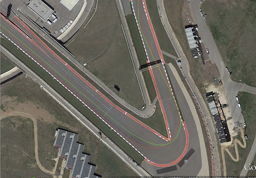
In the below my line is in red and my friend's line is in green. The lines are so different because he is passing a car going into T1 at COTA.
I know that there have been independent studies done that say the VBox GPS data is among the best. I was trying to find out if there was a setup or hardware issue (something that can be fixed) with the AiM system that had caused these anomalies. I have looked at .kml files from other drivers and while there are some questions about the track boundaries, there was nothing as out of bounds this session.
Texas RS: that's the stuff I am talking about. It's just impossible with the AiM hardware/software to do this.
It's also impossible to pull out individual laps on the AiM to do this. Only full sessions, but the fix is coming...
I meant on the VBox, the white course limits map is not particularly good, not tried a .kml export yet.
__________________ -Peter Krause www.peterkrause.net www.gofasternow.com
"Combining the Art and Science of Driving Fast!"
Specializing in Professional, Private Driver Performance Evaluation and Optimization
Consultation Available Remotely and at VIRginia International Raceway
1. Using VBox Tools open desired .VBO file.
2. Under View select Main graph
3. Using the edit tools delete the laps you do not want
4. Under File > Export chose Export to Google Earth
5. You will be prompted to define the location and filename to save the .KML file
To use the file open Google Earth and open the .KML file and that should allow you to fly to the track and then you can zoom in like the turn 1 view I shared previously.
I think I have your email so I will send you a .kml file to play with on Google Earth. Let me know if I can provide any more assistance.
I'll be at TWS again tomorrow, at least in the AM, come see me and I'll explain what I know in person. Look for me by Steins orange pumpkin in garage 2, I have to put a p/s hose on it early in the AM.
See you at the track !
Viking
Originally Posted by Texas RS
Has anyone had issues with the Aim GPS engine? Any idea what causes this or what to do about it?


 03-13-2015, 07:08 AM