When you click on links to various merchants on this site and make a purchase, this can result in this site earning a commission. Affiliate programs and affiliations include, but are not limited to, the eBay Partner Network.
Wondering if someone could advise/assist with setting up track maps for an Autocross application for Circuit Tools/VBOX. I don't own one yet - evaluating applications pre-purchase.
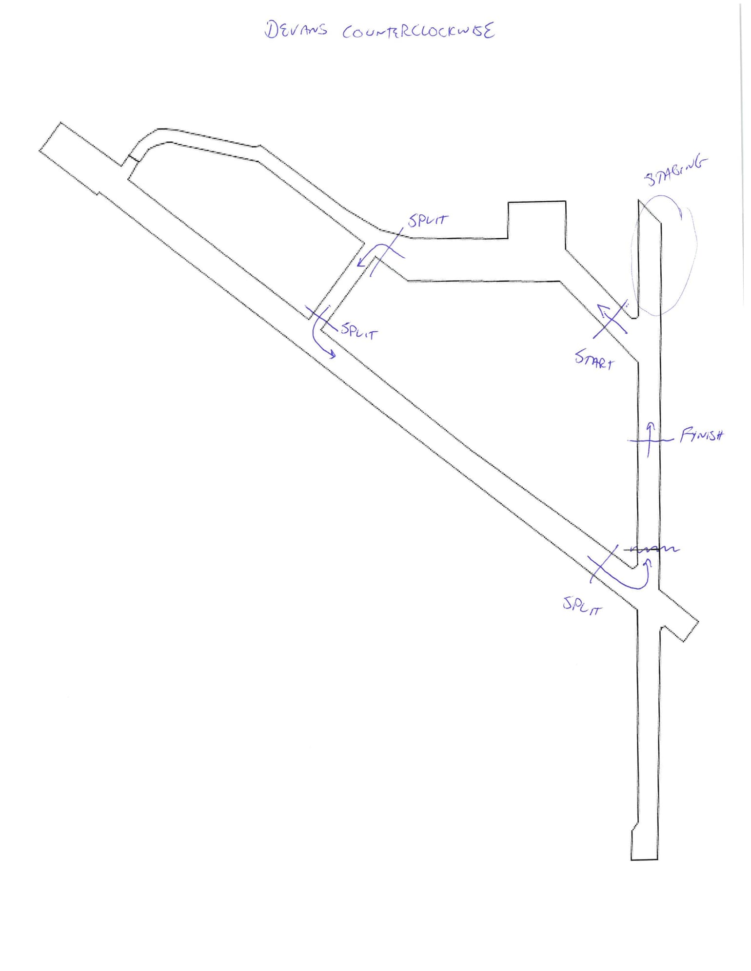
My club runs at Fort Devans in Ayer, MA. It is an old airfield. We run different courses each day, and they may be clockwise or counterclockwise, but along the same general path (elements are however different). The start and finish lines move around a bit, but are generally in the same area.
I would like VBOX timing for self-improvement and co-driver comparison, but not necessarily to be accurate to the official timing system. Moreover, although I can think of several ways to program the exact start/finish of the day, time is tight in AX and assume no time for this.
Thus, I propose two generic course maps be programmed, one for clockwise and one for counterclockwise with start, finish and splits conservatively placed to capture the runs.
From VBOX docs, I believe that I can select the proper course ('Devans clockwise' or 'Devans counter clockwise') using the VBOX OLED at the start of day and then just leave it. I've read about how to create tracks with Google Earth, but can't figure out how to preprogram with separate start finish lines and splits. Looks like the Circuit Tools track database already has a "Fort Devans", but this includes unused portions of the airfield for my club and has the start/finish lines in the wrong places for my club.
Using the preprogrammed track as a backdrop, I've drawn out what I think would work.
Can anyone kindly confirm my assumptions, provide thoughts on how to program (ahead of time) this; and otherwise provide any general feedback on the application.
Fort Devens. Wow. Went to school up there many years ago. My buddies, KTR Engineering are right across the street.
If you call Jim Lau or Bryan Cowles at Racelogic USA in Farmington Hills, Michigan, they can probably help. I think this can be done, I just haven't done it or tested it. The nice thing is you can, with the VBOX video, set the gates as your start/finish (like a hillclimb) before the runs, OR add them later, saving the "track"
If you need a number for them, let me know.
__________________ -Peter Krause www.peterkrause.net www.gofasternow.com
"Combining the Art and Science of Driving Fast!"
Specializing in Professional, Private Driver Performance Evaluation and Optimization
Consultation Available Remotely and at VIRginia International Raceway
Nice maps of Devins. If you need other map info, talk to Scruffy. I know he has the place drawn in CAD (probably a .dxf or .dwg) for the autocross layout. I'm sure he can help. You might talk to him if he has or knows of any data for autocross. With the number of autocrosses he does, he might know the best solution.
For sure it can be done and the finish is a bit easier to pin down. My thoughts would be to pin the finish maybe 25 feet after lights because that is where you actually hit the brakes.
If all autocross events are with Porsche than it should not be a problem.
I need to update my maps this year, as Devens has continued to fall apart. My maps have all sewers, cracks, painted runway lines, etc. Just a lot more cracks now.
May take a few days, home sick now.
Feel better.
In the meantime, I spoke to Racelogic and it is all possible.
One uses a separate map (can use the one already in the database for Devans or draw a new one in Google Earth) and splits (plus start/finish) file as programming for the VBOX scene live recording.
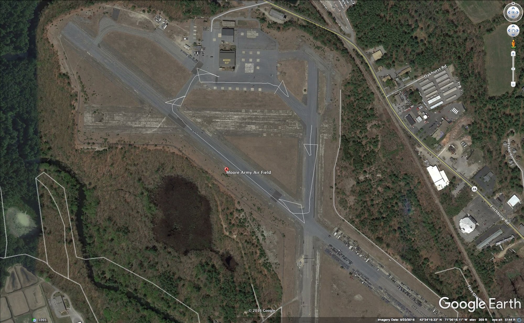
I was able to pull up Devans (specifically Moore Airfield, Ayer, MA) on Google Earth and draw a path indicating example start/finish and split for a generic clockwise run. I then imported this into 'Performance Tools' and was able to pin down the exact start/finish and splits and then export to a Splits file for use in the live VBOX and if needed Circuit tools. I even loaded a last season autocross run from HLT into circuit tools and applied the splits.
Specifically, Moore Army Air Field
42�34'19.33" N 71�36'16.11" W
Here's the clockwise path defined to provide start/finish and a few splits for a generic clockwise run.
The path is imported to Performance Tools where one specifically indicates the points and then creates the Split file.
Despite lack of time to do this, I've been thinking if there is any easy way to log the start and finish lines of the day's course during the course walk and then somehow program these points into the VBOX ahead of the day's runs.
The most obvious way is to either drive the vbox around the course (not possible) or carry it around during the course walk. This would be impractical.
So......During the course walk, I could log a path from the start line to the finish line with a GPS. Then, after the course walk (here is where there is no time), open the laptop, import the logged course to google earth, overlay another path marking the start, finish and splits the way Racelogic software likes it, save this path to a file. Then start Performance Tools, import the path file just saved, mark the start, finish and splits and save to a 'splits file' on the SD Card the VBOX uses. Then, in the car, using the OLED, select the generic track map for Devens and the just saved Splits file. I tried/silulated all of this and it should be under 5 min (probably too long). Nonetheless, I can use the same precise splits file for better analysis in the evenings using the above discussed (in this thread) generic splits for Devens in each direction.
As a test, I walked a short path in my neighborhood using GAIA (hiking logger app for iphone) stopping in the center of a few driveways to simulate the start or finish line. The logging was imprecise and drifted a bit - likely the iPhone GPS. I then did the same thing using the same iphone and app, but with a Dual XGPS160 BT GPS. Much better- definitely usable. I'll have to somehow mount the Dual to a cap so it has a clear view of the sky. A bit nerdy, but it will work.
Other GPS logging options could be a basic handheld GPS with WAAS and GLOSNASS or even a VBOX Sport. The software steps stay basically the same.
If anyone has any thoughts or experience with similar, let me know.
With video, you make the run and then using the synced video to validate and "all windows" to validate, you use the start/finish function to mark the respective points. Then, you "save" the circuit.
You wouldn't have OLED splits displayed for the first run, but rarely is your first run the best.
You could use a VBOX Sport, the most accurate 20Hz solution, but then you'd need to make up the start finish and save it as a .cir file in Performance Tools (which might be easier and quicker).
With video, you make the run and then using the synced video to validate and "all windows" to validate, you use the start/finish function to mark the respective points. Then, you "save" the circuit.
How does one mark the start and finish line (and splits) from inside CT other than the track wizard (which is not video synced). It would be nice if when in All Windows view, and you saw the lights line up in the video you could set a start/finish/split point, but I have not figured this out.
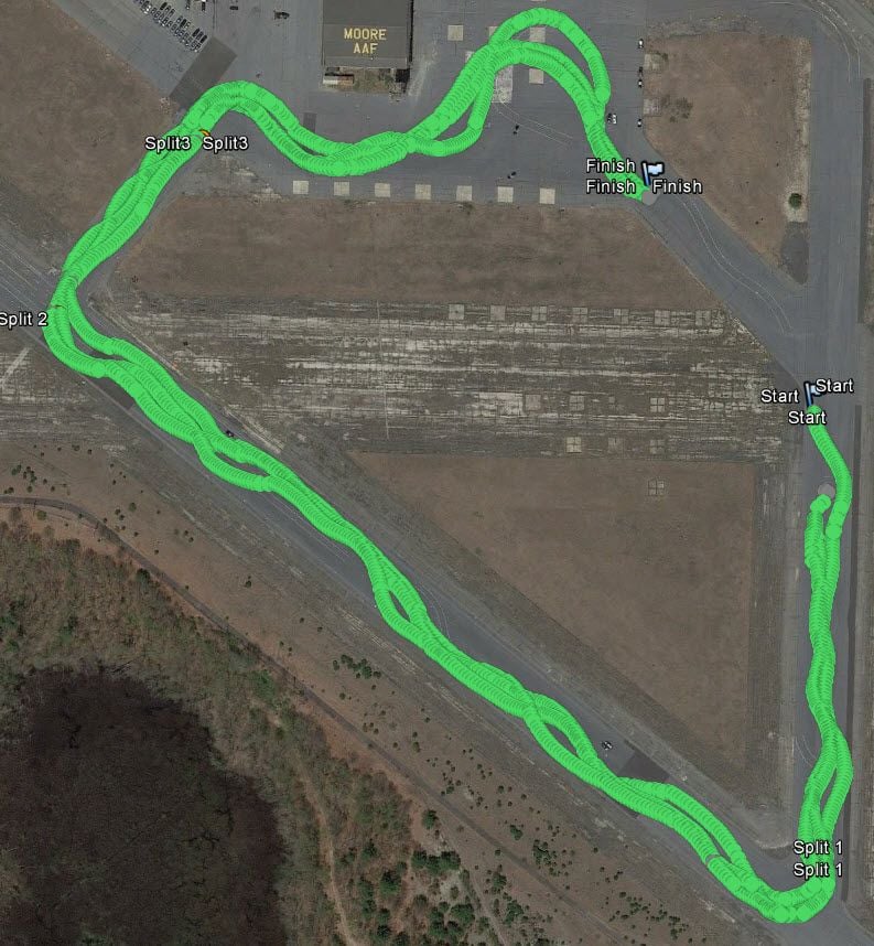
Now that I am more familiar with Google Earth and GPS log files, I was able to find some AX runs with Harrys that had proper start/finish points setup. These are 3 runs from different days, all clockwise. To give some sense of scale, the gap between start points is about 150 feet. The finish points are all clustered within 12 feet. Thus for a generic clockwise profile, I can certainly place the start point just a little down course from the indicated points and finish just a little up course. This should be fine for self improvement and driver comparison purposes. I don't think I need to bother with more precise start/finish point mapping.
 01-09-2017, 03:21 PM